Wildfire technology is improving quickly.
Earth-observation satellites can detect heat signatures, map vegetation conditions and monitor smoke. Artificial intelligence can identify risk patterns. Weather models can estimate how wind, temperature and humidity may influence fire behavior. Physics-based models can simulate possible spread.
These capabilities matter. But identifying where a fire may occur or predicting where it may move is only part of the operational problem.
The greater value emerges when wildfire intelligence changes what organizations do before ignition.
That means moving from:
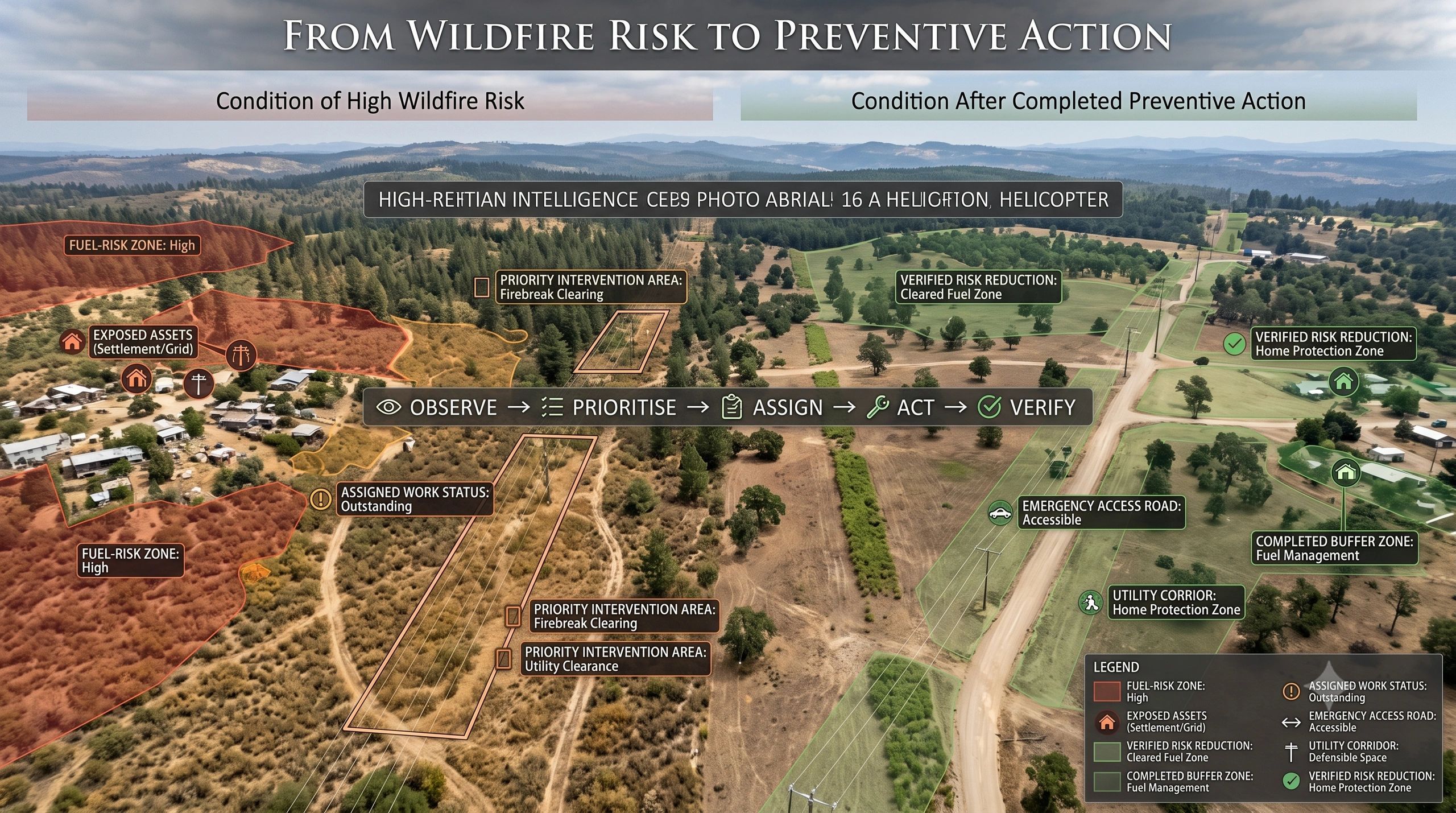
risk map → preventive work → verified risk reduction
This is where wildfire intelligence starts becoming an operational system rather than another layer of environmental information.
The market is moving upstream
Most people associate wildfire technology with emergency response:
- Detect the fire
- Confirm its location
- Predict its direction
- Issue an alert
- Support evacuation and suppression
These activities remain essential. However, intervention after ignition usually happens under severe time pressure. Weather changes quickly, access routes may become unsafe and available resources are limited.
Prevention operates on a different timescale.
It asks questions such as:
- Where has combustible vegetation accumulated?
- Which power lines, roads and settlements are exposed?
- Which firebreaks are incomplete or degraded?
- Which water sources are available?
- Which access routes are usable by response teams?
- Which preventive actions are overdue?
- Who is responsible for completing them?
These are not purely modelling questions. They are asset, workflow and governance questions.
ESA’s recent wildfire initiatives reflect this broader direction. Projects are combining Earth observation, artificial intelligence and physics-based fire models. Its Wildfire Preparedness programme also extends the focus towards risk assessment, fuel-load management and preventive intervention.
This signals an important shift: wildfire intelligence is moving beyond observing fire events towards changing the conditions that allow them to become disasters.
A risk map is not an intervention plan
A technically strong wildfire-risk model may identify a high-risk zone based on vegetation dryness, terrain, weather and historical fire patterns.
But the map does not automatically tell an organization what to do next.
The high-risk area might contain:
- Dense vegetation near a transmission corridor
- Informal settlements with limited evacuation access
- A degraded firebreak beside agricultural land
- A road that emergency vehicles cannot use
- Critical telecommunications infrastructure
- Protected habitat where vegetation removal is restricted
Each condition requires a different response, authority and verification method.
A utility may need to clear vegetation around a power line. A forestry department may need to conduct controlled fuel reduction. A municipality may need to restore an access road. An emergency agency may need to reposition equipment. A landowner may need to comply with a prevention notice.
The same risk signal therefore produces different actions depending on the assets, land rights, operating rules and organizations involved.
This is why wildfire intelligence needs an operational context.
The missing layer is an intervention twin
A useful wildfire system should connect environmental evidence to preventive responsibility.
The operating chain could look like this:
fuel condition → ignition and spread risk → exposed asset or community → intervention zone → responsible organization → preventive work → updated observation → residual risk
This can be understood as a Wildfire Intervention Twin.
It would not attempt to reproduce every environmental process in a visually impressive 3D model. Its purpose would be much more practical: maintain a current representation of wildfire risk, the interventions required and the evidence that those interventions were completed.
Such a system could combine:
- Satellite observations of vegetation condition and burn history
- UAV surveys of firebreaks and hard-to-observe areas
- Weather and soil-moisture information
- Terrain and land-cover data
- Roads, power lines, settlements and critical facilities
- Land ownership and jurisdiction boundaries
- Field inspections and maintenance records
- Available crews, vehicles and water resources
- Work orders and completion evidence
The result would be more than a hazard map. It would become a continuously updated view of intervention readiness.
Not every alert is ready for action
Multisource intelligence introduces another problem: different observations may not agree.
A satellite product may indicate dry vegetation across a broad area. A drone survey may show that part of the vegetation was recently cleared. A field team may report that the firebreak is complete, while newer imagery suggests that one section remains obstructed.
The system must know:
- Whether observations refer to the same location or event
- When each observation was collected
- What area each source covers
- How confident the result is
- Where sources disagree
- Which source is authoritative for a particular decision
Without this context, combining more datasets can produce greater uncertainty rather than better intelligence.
A practical system should therefore classify evidence according to what it can support:
- Inform: useful context, but insufficient for operational escalation
- Alert: a condition requires attention or further verification
- Decide: evidence is strong enough to select an intervention
- Act: the intervention has appropriate authority and resources
- Verify: updated evidence confirms whether the work reduced the risk
This prevents a model output from being treated as an automatically authorized action.
It also creates a traceable record of why an intervention was initiated, who approved it and what happened afterwards.
Prevention requires ownership
Many wildfire programmes struggle not because risk is invisible, but because responsibility is fragmented.
Vegetation may cross private, municipal and protected land. A utility may own the infrastructure but not the surrounding property. A road department may control access routes, while emergency services depend on them. Environmental regulations may restrict how and when vegetation can be removed.
A preventive intelligence system must therefore represent organizational boundaries alongside geographic ones.
Every intervention should answer:
- What condition triggered the work?
- Which asset or community is exposed?
- Who owns the land?
- Who is responsible for reducing the risk?
- Who has authority to approve the intervention?
- What resources and permits are required?
- When must the work be completed?
- What evidence will demonstrate closure?
If these questions remain outside the platform, the risk map may be accurate while the operational response remains slow.
Verification closes the loop
Completing a work order does not necessarily mean that the risk has been reduced.
A contractor may report that vegetation clearance is finished. But was the correct area cleared? Was the required width achieved? Has material been left nearby? Has regrowth occurred since the intervention?
Verification can combine timestamped field photographs, UAV imagery, satellite observations and geolocated inspection records. The evidence should remain connected to the original risk condition and intervention boundary.
The system can then compare:
risk before intervention → work completed → physical condition after intervention → residual risk
This is the point where wildfire intelligence becomes measurable.
Organizations can evaluate which interventions worked, how long their effect lasted and where maintenance strategies need to change. Over time, they can move from reacting to isolated alerts towards managing a portfolio of preventive work based on exposure and residual risk.
The commercial opportunity is operationalization
Satellite companies, AI developers and environmental-modelling specialists will continue improving detection and forecasting.
But many governments, utilities, forestry operators and infrastructure owners will still need help connecting those outputs to assets, responsibilities, field activity and evidence of completion.
That creates a downstream opportunity for geospatial platforms and implementation partners.
The strongest proposition may not be:
We can produce another wildfire-risk model.
It may be:
We connect wildfire-risk intelligence to preventive work and verify whether that work changed physical conditions.
This model can begin with a narrow use case, such as vegetation management around electricity infrastructure, and then expand into firebreak maintenance, road-access readiness, community exposure and regional resource planning.
The wider lesson also applies beyond wildfire management.
Environmental intelligence produces value when it changes a decision. Operational intelligence produces value when it ensures that the decision becomes an accountable action. A trusted evidence system demonstrates whether that action achieved its intended physical outcome.
Wildfire preparedness therefore needs a closed intervention loop:
observe → contextualize → prioritize → assign → act → verify → reassess
The future of wildfire intelligence will not be defined only by how early a system detects danger.
It will be defined by whether that intelligence helps reduce the conditions that turn an ignition into a disaster.