The devastating flash floods along the Nepal–Tibet border on 26 August appear to have exposed a difficult weakness in modern disaster management.
The initial assessments described in the briefing suggest that this was not a conventional rainfall-driven flood.
A massive high-altitude glacier and rock mass appears to have collapsed on the Tibetan side of the border, descended thousands of feet and generated a fast-moving mixture of water, ice, mud and rock that entered the Lhende Khola and Bhote Koshi river systems.
The collapse was so significant that seismic instruments reportedly registered an event equivalent to magnitude 5.2.
That created a fundamental detection problem.
The first signal looked like an earthquake.
The downstream consequence behaved like a flash flood.
But the originating hazard was a high-altitude structural failure involving glacier, rock, gravity and potentially long-term permafrost degradation.
Our monitoring systems tend to classify these as separate problems.
Nature does not.
And that, to me, is the larger lesson.
We may be entering an era of compound hazards
For decades, flood warning has largely depended on a familiar sequence:
Rainfall → river rise → threshold exceeded → warning → evacuation.
That model works when nature gives us time.
But imagine another sequence:
Glacier instability → structural collapse → rock/ice avalanche → rapid melting and debris entrainment → river surge → downstream destruction.
The entire chain can develop in minutes.
There may be no prolonged rainfall.
There may be no steadily rising reservoir.
There may be no river gauge upstream providing enough lead time.
The sources note that in the Himalayan terrain involved, even an effective warning system may sometimes provide only 10–15 minutes before the impact reaches vulnerable downstream settlements.
This changes the engineering problem completely.
The question is no longer:
"How accurately can we forecast the flood?"
It becomes:
"How quickly can we recognize that something unusual has happened upstream, understand its possible downstream consequence and convert that understanding into action?"
That requires more than meteorology.
Satellites are essential. But satellites alone cannot solve this.
As someone who has spent decades working around geospatial technology, I strongly believe Earth observation will remain one of the foundations of climate and disaster intelligence.
Satellite imagery can identify glacier retreat.
It can track expanding glacial lakes.
SAR can detect surface displacement.
Historical imagery can reveal landscape change.
Digital elevation models can help simulate potential flow paths.
But we should be careful about expecting satellites to become universal real-time alarm systems.
A sudden structural fracture presents a very different problem.
A satellite may revisit an area only periodically.
The critical crack may be hidden beneath ice.
Sub-glacial water pressure cannot necessarily be observed directly from above.
A hanging glacier can remain apparently stable until the moment the mechanical system crosses a threshold.
In situations like this, satellites are extremely powerful for understanding risk before the event and reconstructing what happened after the event.
The missing layer is often the seconds-to-minutes operational window in between.
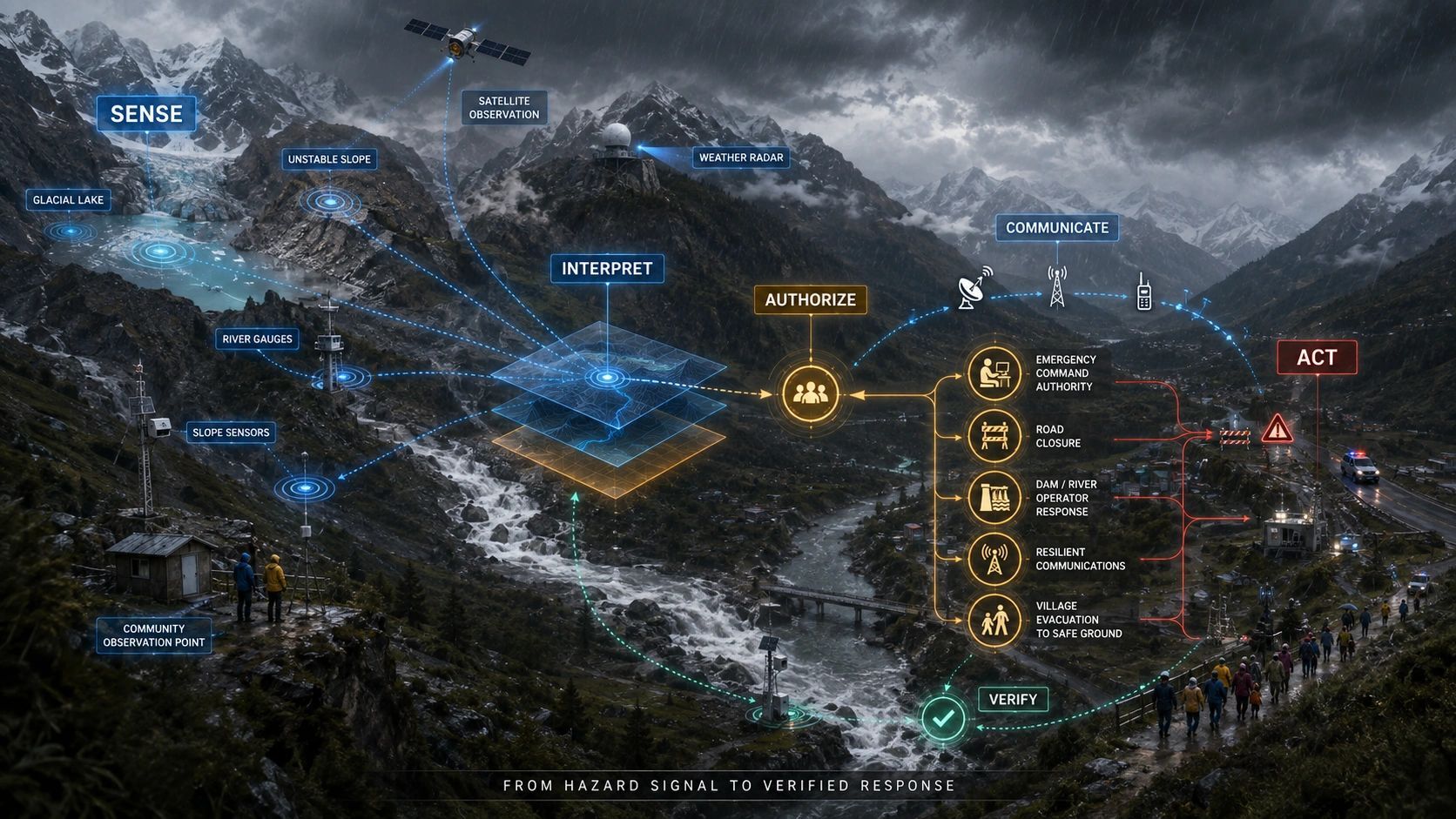
This is where geospatial intelligence must become sensor intelligence.
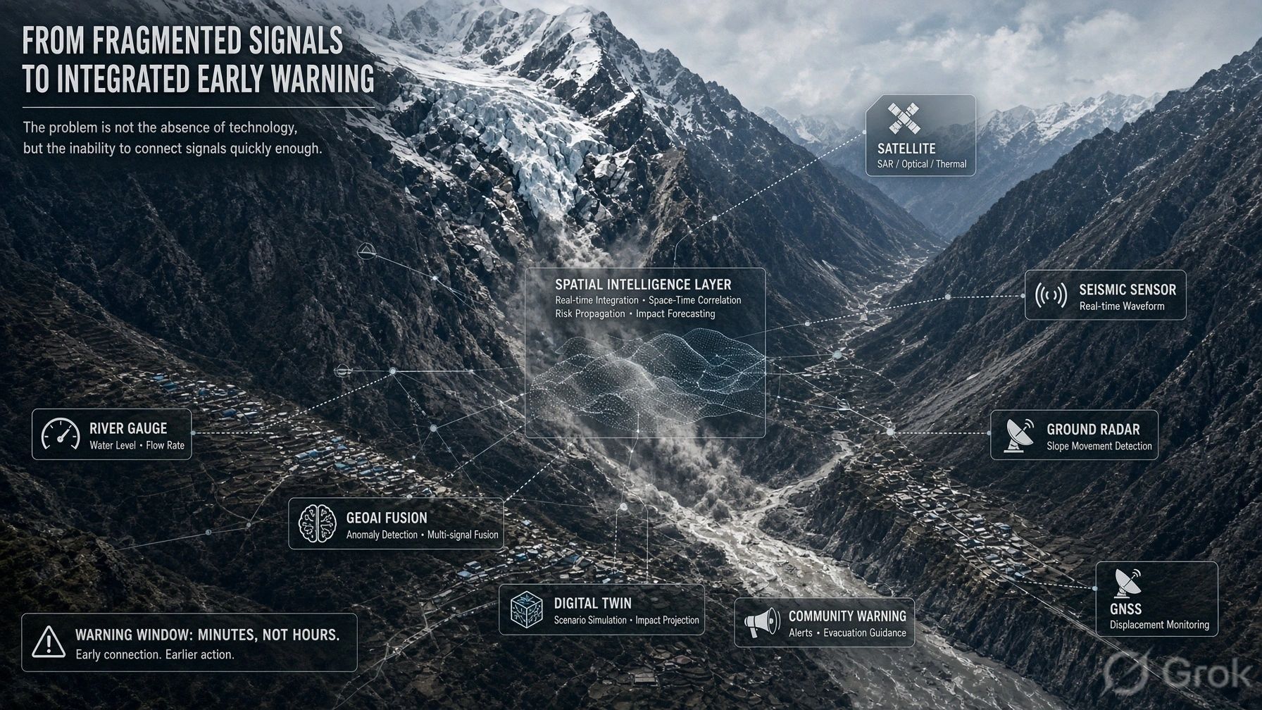
I see the future architecture looking less like a single monitoring technology and more like a distributed spatial sensing system.
Satellite Earth observation.
Ground-based radar.
GNSS displacement monitoring.
Micro-seismic sensors.
River gauges.
Weather stations.
IoT devices.
Terrain and hydrological models.
Drone-based inspections.
Historical hazard databases.
Local observations.
All of them connected through a common spatial context.
An unusual seismic signature should not remain simply a seismic event.
The system should immediately ask:
Where did it originate?
Is there a glacier at that location?
Is the slope classified as unstable?
Has satellite or radar data indicated displacement?
What river network lies below it?
Which communities, bridges, hydropower facilities and roads sit within the potential flow corridor?
How long would a debris surge take to reach them?
That is where GeoAI, sensor fusion and digital twins stop being visualization technologies and become operational infrastructure.
A disaster digital twin should not merely show the valley in 3D.
It should understand relationships.
Slope → glacier → drainage → river → settlement → infrastructure → consequence.
And it should continuously update the confidence attached to those relationships.
The real technology gap exposed by this event is not simply the absence of more satellites, seismic instruments or river gauges. Many of these technologies already exist. The gap is our ability to connect them fast enough to recognize a compound event, understand where its consequences are heading and trigger an operational response within minutes.
Cross-border hazards also require cross-border data.
There is another important issue here.
According to the briefing, the initiating collapse occurred roughly 20 km northeast of the Rasuwagadhi border crossing, on the Tibetan side.
The flood did not care about the national boundary.
Sensors, agencies and data governance do.
This is a recurring challenge in geospatial risk management.
The hazard may originate in one jurisdiction.
The infrastructure may lie in another.
The population at risk may live in a third administrative system.
For transboundary Himalayan river basins, early warning therefore cannot be treated only as a national technology project.
It is also a data-sharing and governance problem.
If upstream seismic anomalies, glacier movements and river changes can be exchanged automatically between neighboring countries, even a few additional minutes could become meaningful.
We also need to rethink what "early warning" means.
We often imagine an early-warning system predicting exactly what will happen.
That may be unrealistic for sudden glacier and rock collapses.
Perhaps the objective should instead be rapid anomaly recognition.
The system may not know with certainty that a catastrophic avalanche has occurred.
But it might know that:
A high-energy seismic event originated near a vulnerable hanging glacier.
A downstream sensor detected an abrupt disturbance.
Terrain models show a direct connection to a populated river corridor.
That may already be enough to trigger an automated precautionary warning.
In extreme environments, waiting for perfect certainty may eliminate the warning window entirely.
The Himalayan problem is likely to become more important.
The sources also point to the deeper climatic context.
Long-term warming can thin glaciers, increase meltwater penetration, weaken permafrost and reduce the stability of steep mountain faces.
The final collapse may happen in seconds.
But the conditions that created it may have developed over decades.
That distinction matters.
Climate change does not necessarily "cause" every individual collapse in a simple linear sense.
But it can change the structural conditions under which these failures become more probable.
And that means our monitoring architecture has to evolve with the landscape.
For me, the central takeaway from the Nepal–Tibet disaster is therefore not that satellite monitoring failed.
It is that no single observation system can provide the complete answer anymore.
The future of disaster resilience will depend on connecting observation systems that currently operate separately.
Earth observation tells us what is changing.
Ground sensors tell us what is happening now.
Geospatial models tell us where the consequences may travel.
AI helps detect abnormal patterns.
Digital twins connect those signals to infrastructure and communities.
Governance determines whether that intelligence reaches the right decision-maker in time.
And ultimately, local preparedness determines whether those few minutes actually save lives.
That is the transition we need to make:
From monitoring hazards individually to understanding dynamic systems spatially.
Because the next disaster may not arrive in the form our warning system was designed to recognize.