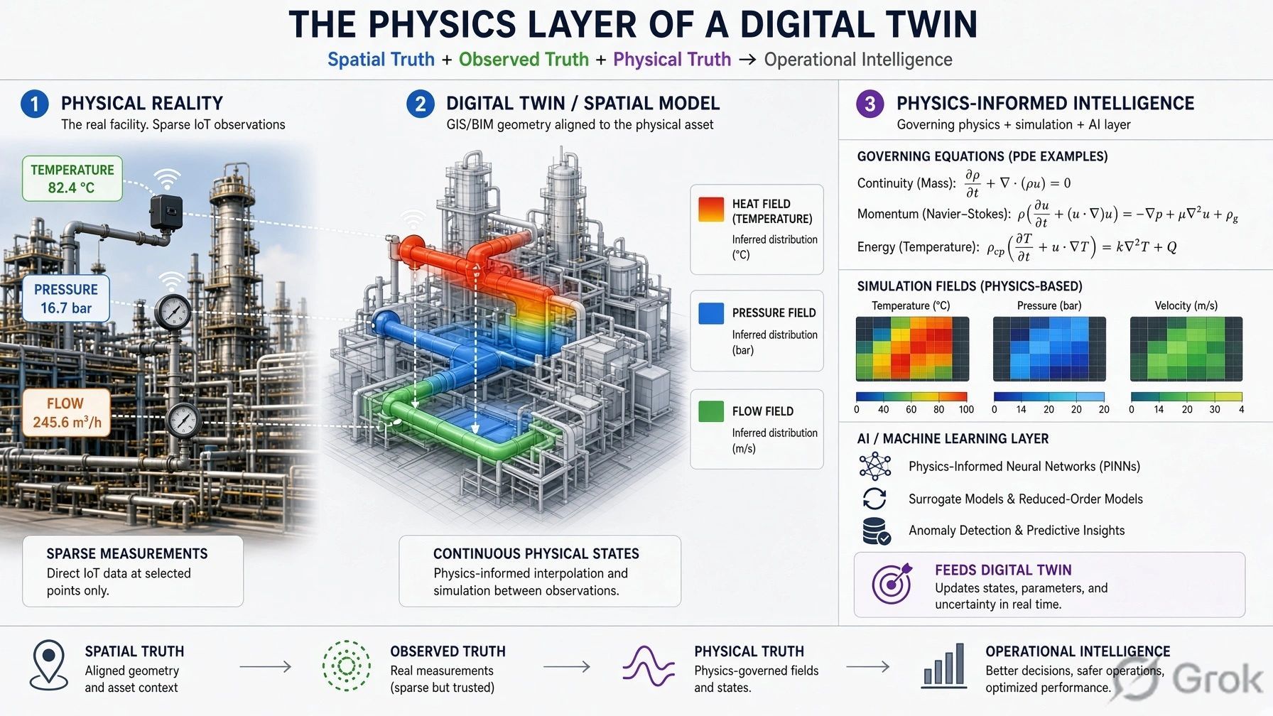
For years, we have been improving Digital Twins by adding more data.
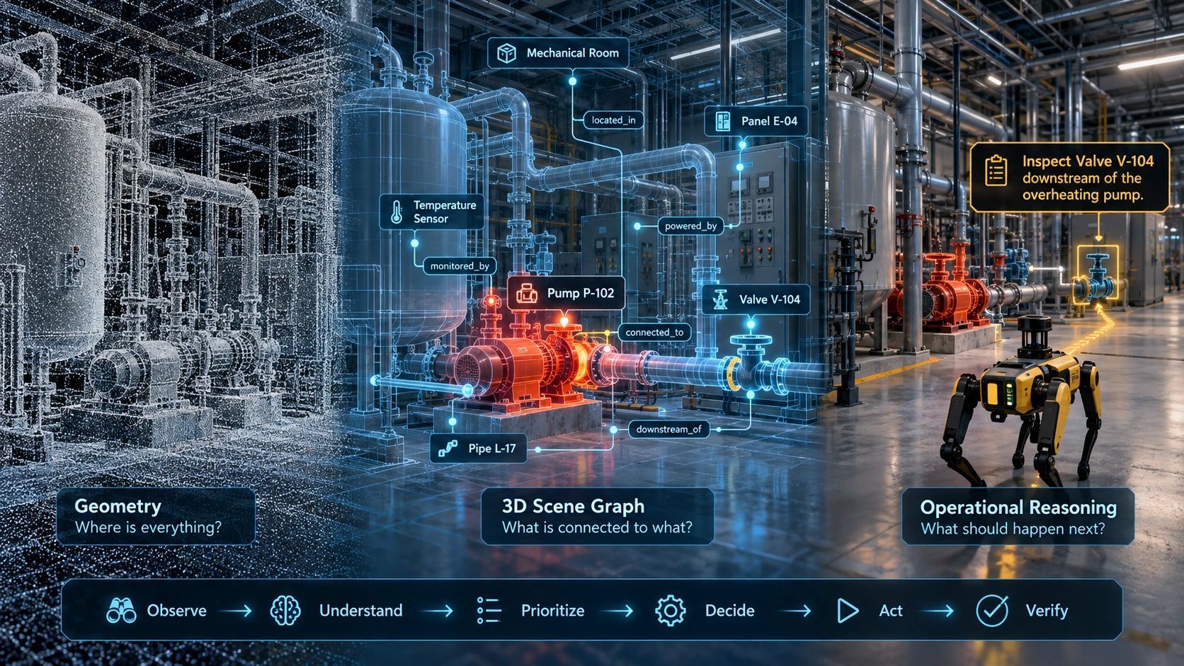
LiDAR gives us geometry.
BIM gives us structure and semantics.
IoT gives us live state.
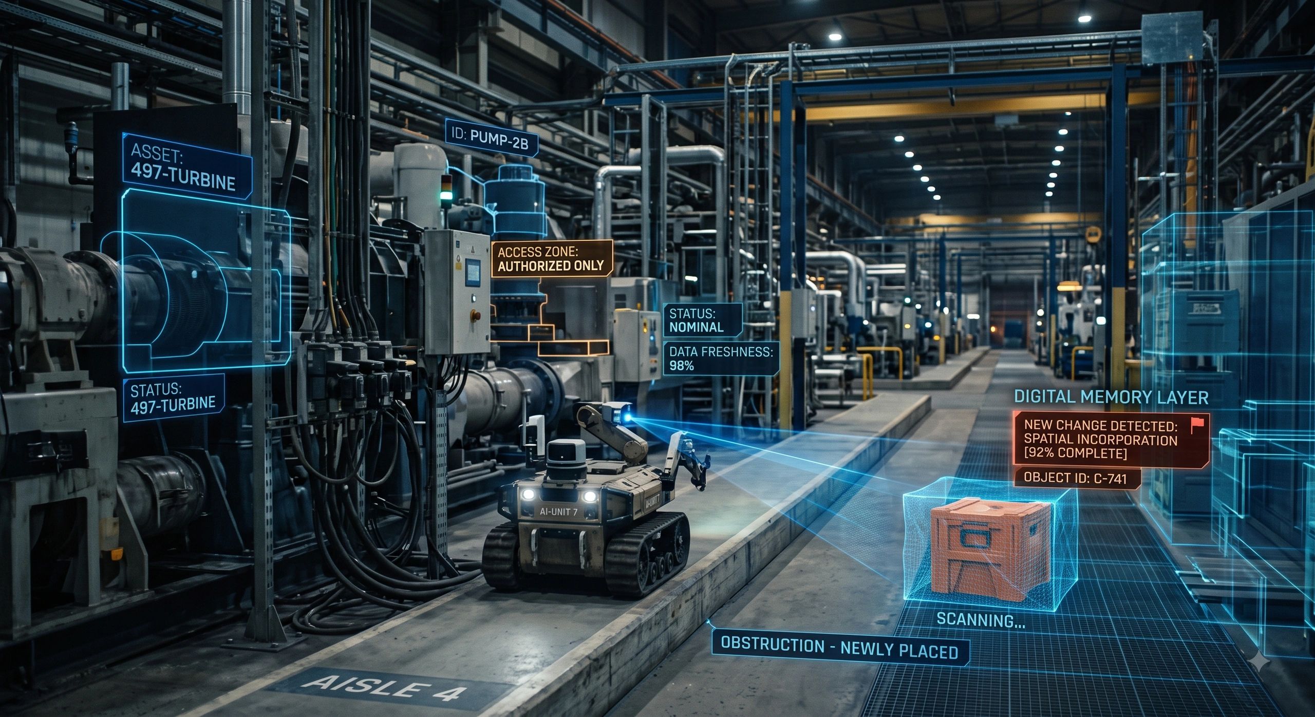
Reality capture keeps the model current.
AI helps detect patterns.
But one major friction remains.
Humans still have to learn how to navigate the system.
We open GIS platforms, BIM viewers, dashboards, asset-management tools and analytics applications. We search layers, isolate objects, filter attributes and interpret sensor feeds.
What if the interaction changed?
Instead of learning the software, what if we could simply ask:
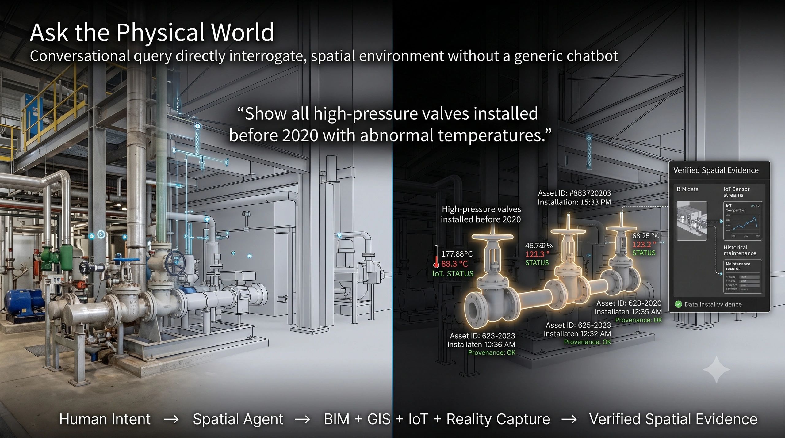
“Show me all high-pressure valves installed before 2020 that are currently running above their normal temperature range.”
And the system could identify the assets, retrieve their operational state and show them directly inside the spatial environment.
This is where Large Spatial Models, 3D-language models and conversational Digital Twins begin to converge.
But the important point is this:
The technology is real. The all-knowing spatial AI is not here yet.
From Language Models to Spatial Models
Large Language Models understand relationships between words and concepts.
Vision-language models can interpret images.
Spatial models are trying to extend that intelligence into 3D environments.
But we need to distinguish several technologies that are often grouped together.
A Large Spatial Model can learn representations of 3D scenes, geometry and semantics.
A 3D-LLM connects 3D representations with language so users can describe, query or reason about spatial environments.
Models such as SpatialLM are pushing further by taking 3D point-cloud information and producing structured representations of rooms, walls, doors, windows and objects.
This is important progress.
But these systems do not yet provide universal human-like spatial understanding.
They perform well within particular datasets, scene types and task boundaries.
So rather than saying that AI has achieved “true spatial reasoning,” a more grounded description is:
AI is becoming increasingly capable of representing, querying and reasoning over explicit 3D spatial relationships.
That distinction matters.
The Near-Term Breakthrough May Not Be the Model
The most practical opportunity today is not to wait for one giant model that understands an entire factory, city or construction site.
A more realistic architecture already exists.
Imagine this stack:
Reality Capture
LiDAR, drones, cameras, RGB-D and photogrammetry capture the environment.
↓
Spatial Reconstruction
The observations become point clouds, meshes, Gaussian representations or 3D scenes.
↓
Semantic Interpretation
AI identifies walls, beams, equipment, spaces and other objects.
↓
Structured Spatial Model
BIM, IFC, OpenUSD, GIS, 3D Tiles or a scene graph preserves geometry and relationships.
↓
Operational Context
IoT, CMMS, ERP, maintenance records and business systems provide live and historical state.
↓
Spatial Agent
An LLM interprets the user’s request and calls the required spatial, database and analytics tools.
↓
Evidence and Action
The relevant assets are highlighted, explained or passed into a controlled workflow.
That is already technically achievable.
And this changes the role of the LLM.
It does not need to know everything.
It needs to understand what the user wants and which trusted system should answer it.
The Conversational Digital Twin Is Already Emerging
Consider the earlier valve query:
“Show me all high-pressure valves installed before 2020 that currently have elevated temperatures.”
A reliable system should not ask an LLM to guess the answer.
The workflow can be deterministic.
The language model identifies the intent.
The asset database finds valves.
The maintenance system filters installation dates.
The IoT platform checks temperatures.
The BIM or Digital Twin resolves the asset IDs to their spatial locations.
The viewer highlights the affected equipment.
So the intelligence is not coming from one model alone.
It comes from orchestration across trusted systems.
This pattern is already appearing in research and commercial platforms.
Conversational BIM systems are being tested against IFC and knowledge graphs.
Digital Twin interfaces are being connected to natural-language querying.
OpenUSD workflows are gaining AI-assisted scene search and modification.
AEC platforms are introducing copilots that understand both user intent and model context.
This is no longer a distant research idea.
It is moving into implementation.
What About Autonomous Scan-to-BIM?
This is another area where expectations need to be managed.
AI can already segment point clouds and identify many structural classes:
walls,
columns,
beams,
doors,
windows,
equipment,
and other objects.
This can significantly reduce Scan-to-BIM effort.
But recognising an object is not the same as producing a trustworthy BIM model.
A complete workflow still involves:
registration,
noise removal,
segmentation,
instance detection,
geometry fitting,
object classification,
topology,
relationships,
attributes,
and quality assurance.
So the direction is clear:
AI-assisted Scan-to-BIM is real.
But fully autonomous Scan-to-BIM across arbitrary industrial or infrastructure environments is not yet a solved problem.
The likely future is progressive automation rather than an overnight replacement of modelling teams.
The XR Use Case Shows Why Governance Matters
Now imagine an engineer wearing an XR headset.
They point at a concrete slab and ask:
“Can I drill here?”
The concept sounds powerful.
But this is exactly where conversational spatial AI can become dangerous if it is treated as an oracle.
The BIM may show a conduit.
But was it installed exactly as designed?
Has the slab been scanned since construction?
How accurate is the headset localization?
What is the coordinate uncertainty?
Has the asset moved?
How recent is the information?
A responsible system should not simply answer:
“Yes, it is safe.”
It should reason within governed constraints.
A better response may be:
“An active electrical conduit is recorded inside the proposed drilling safety envelope. The location should be verified before drilling.”
That is a very different design philosophy.
And it leads to a broader point.
Spatial Intelligence Needs More Than Geometry
If spatial agents are going to influence real operations, every spatial claim will need context.
Not only:
Where is the object?
But also:
Which object is it?
When was this observation made?
Which source produced it?
How accurate is the location?
What evidence supports the current state?
What has changed since the last observation?
Who is authorised to act?
This is why identity, time, provenance, confidence and governance become as important as the 3D model itself.
Without them, conversational spatial AI risks becoming a very convincing interface to uncertain information.
The Dashboard May Not Disappear
It is tempting to say that spatial AI will eliminate dashboards.
I do not think that is quite the right conclusion.
The dashboard may remain.
But it may stop being the primary interface.
Today the workflow is often:
Human → software → layer → object → filter → analysis
The emerging workflow may become:
Human → intent → spatial agent → trusted tools → evidence → action
The 3D environment then becomes less of a place where the user manually searches for information and more of an evidence surface where results can be inspected and verified.
That could be a much more significant change than simply adding another AI feature to BIM or GIS.
The GeoThinking Lens
The most important shift is not that a Digital Twin can “talk.”
It is that the physical world is becoming increasingly machine-queryable.
Reality capture provides current geometry.
BIM provides semantics.
IoT provides state.
Digital Twins provide operational context.
Spatial AI provides perception.
LLMs provide intent interpretation.
Knowledge graphs provide relationships.
Agents connect tools.
And eventually Physical AI may close the loop by acting in the real world.
The challenge is making sure that every step remains traceable, verifiable and governed.
Because once AI starts reasoning about physical space, the question is no longer only:
“Can the machine understand the environment?”
The more important question becomes:
“Can we trust the spatial evidence on which the machine is reasoning?”
That may determine how quickly Large Spatial Models move from fascinating research into real operational infrastructure.
GeoThinking Takeaway
The near-term opportunity is not an all-knowing spatial foundation model.
It is the convergence of 3D perception, BIM, GIS, Digital Twins, IoT, knowledge graphs, deterministic tools and LLM-based agents.
Together, they can create a new way to interact with physical reality:
not by navigating software,
but by expressing intent.
And that may be the real beginning of conversational spatial intelligence.