For years, the Earth observation industry has focused on increasing satellite capacity.
More satellites. More sensors. More frequent revisits. Better spatial resolution. More specialized constellations.
That supply constraint is beginning to ease. The next bottleneck is appearing much closer to the enterprise:
Can an observation trigger the right decision, by the right person, with enough evidence to justify action?
Muon Space’s recent $250 million Series C illustrates this transition. The company is expanding its satellite manufacturing capacity and targeting production of up to 500 satellites annually by 2027. Its work spans Earth observation, wildfire detection, communications and orbital computing.
This is more than a funding story. It signals how quickly space-based observation capacity is industrializing.
But manufacturing hundreds of satellites does not automatically create hundreds of useful enterprise decisions.
More observation does not guarantee more action
Satellite data can reveal a possible wildfire, crop-stress pattern, ground movement, flood extent, illegal excavation, maritime anomaly or infrastructure change.
Yet the observation is only the beginning of the operational process.
An enterprise must still determine:
- Which asset, parcel or operational area is affected?
- How recent and reliable is the observation?
- Is the detected change material?
- What other evidence supports or contradicts it?
- Who is responsible for investigating it?
- What action is permitted?
- How will the outcome be verified?
If those connections are missing, additional satellite capacity produces more alerts, imagery and dashboards but not necessarily better decisions.
The scarce layer is therefore moving downstream: from collecting observations to operationalizing them.
The gap between a signal and a business event
A satellite detects something in a geographic area. An enterprise manages assets, contracts, risks, responsibilities and workflows.
Those are different information environments.
A thermal anomaly becomes operationally useful only when it can be connected to a named forest compartment, transmission corridor, industrial asset or insured property.
A crop-stress signal matters when it is related to the correct field boundary, crop stage, irrigation history and farm intervention.
Ground deformation becomes a business event when it is associated with a pipeline, railway, mine, building or construction package—and when its rate of change exceeds an agreed threshold.
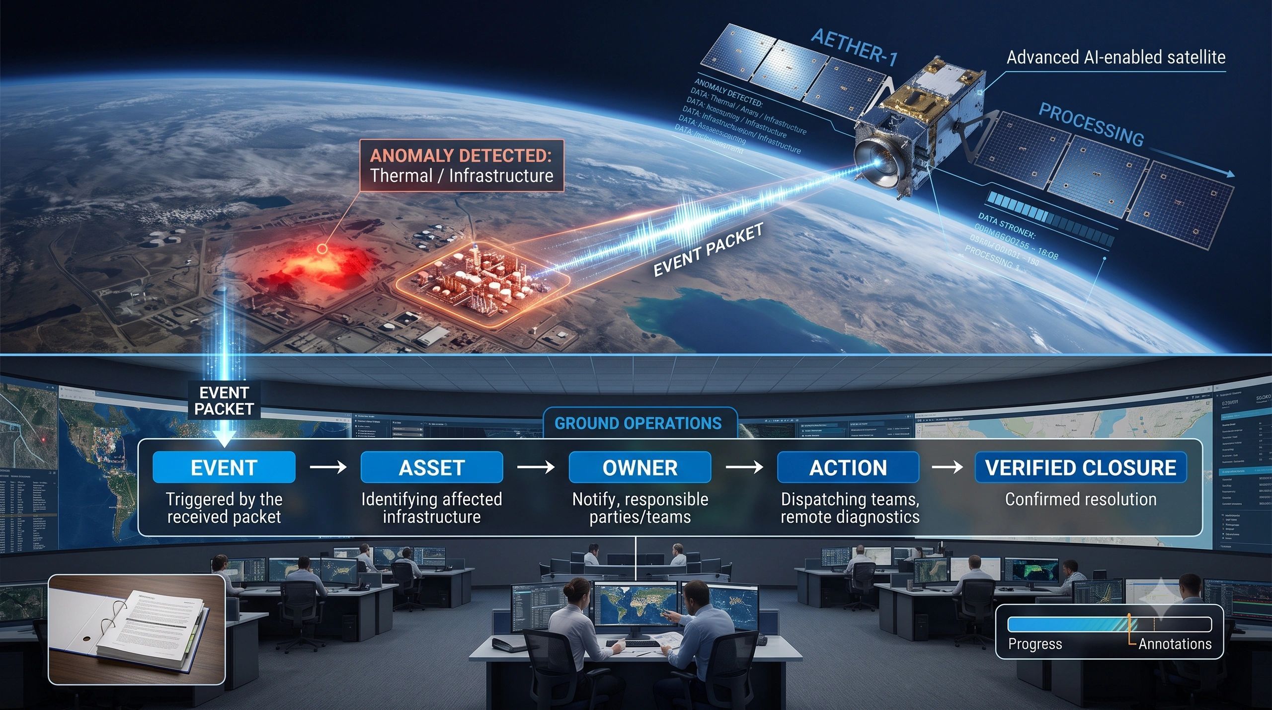
This translation can be represented as an operational chain:
Observation → Change or event → Asset or territory → Confidence and freshness → Business consequence → Responsible party → Verification → Intervention → Outcome evidence
Most organizations have parts of this chain. Few have the complete workflow.
They may receive imagery without asset context, detect anomalies without assigning ownership, or initiate field activity without preserving the evidence needed to evaluate whether the intervention worked.
Three layers are needed
Turning Earth observation into enterprise action requires more than another image portal. It requires three connected layers.
1. Observation intelligence
The first layer identifies what may have changed.
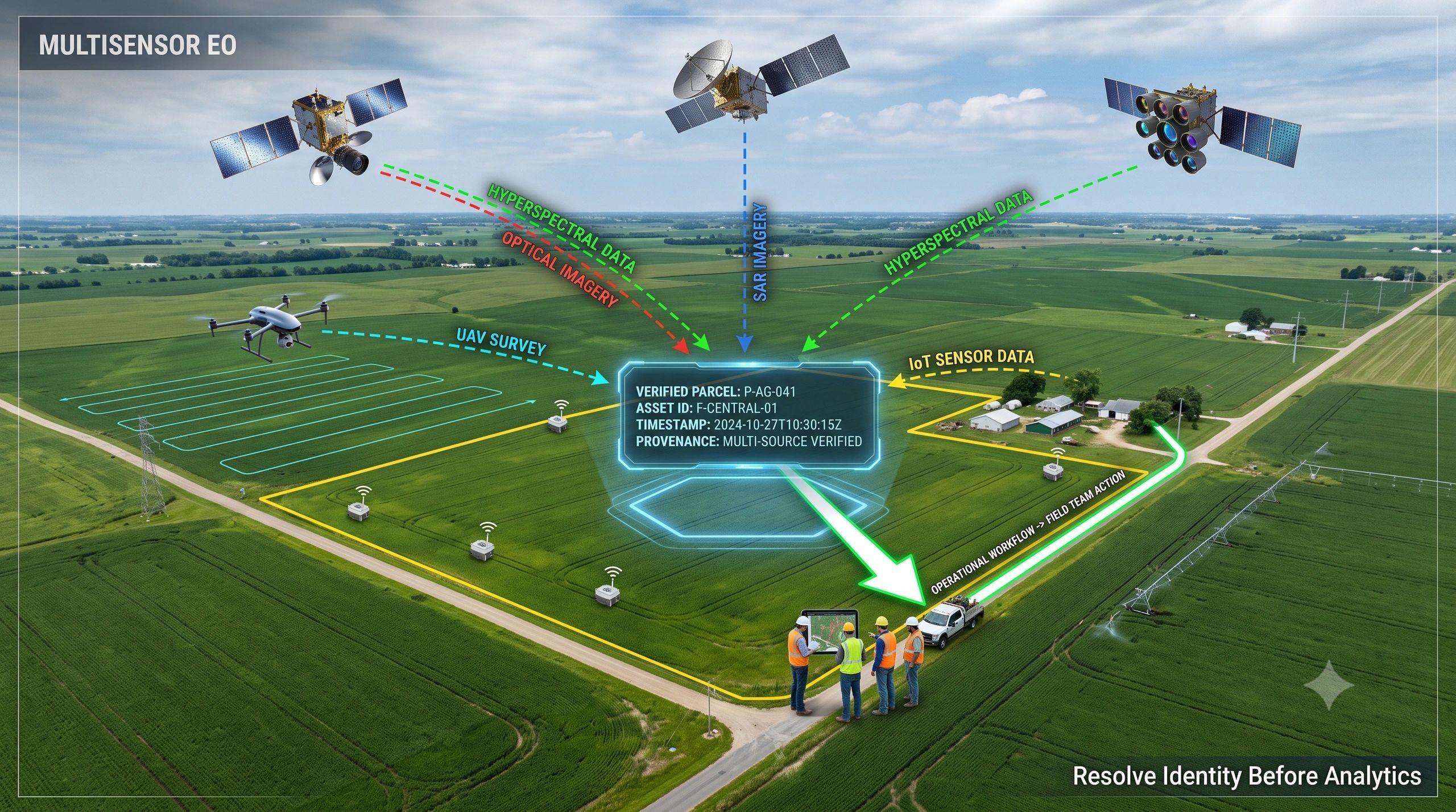
This could combine optical, SAR, thermal, hyperspectral or environmental observations. AI may support classification, change detection, pattern recognition and prioritization.
But every result should retain its observation date, source, resolution, processing history, uncertainty and limitations.
A confident-looking alert without provenance is difficult to govern.
2. Operational context
The second layer explains why the observation matters.
This is where satellite-derived intelligence must connect with enterprise information such as:
- asset identity and location;
- land ownership or operational boundaries;
- BIM and engineering records;
- maintenance history;
- IoT and weather data;
- contracts, permits and compliance thresholds;
- responsible teams and service providers.
The objective is not simply to display the satellite result over a map. It is to interpret that result within the operating condition of the asset or territory.
3. Action and verification
The third layer determines what happens next.
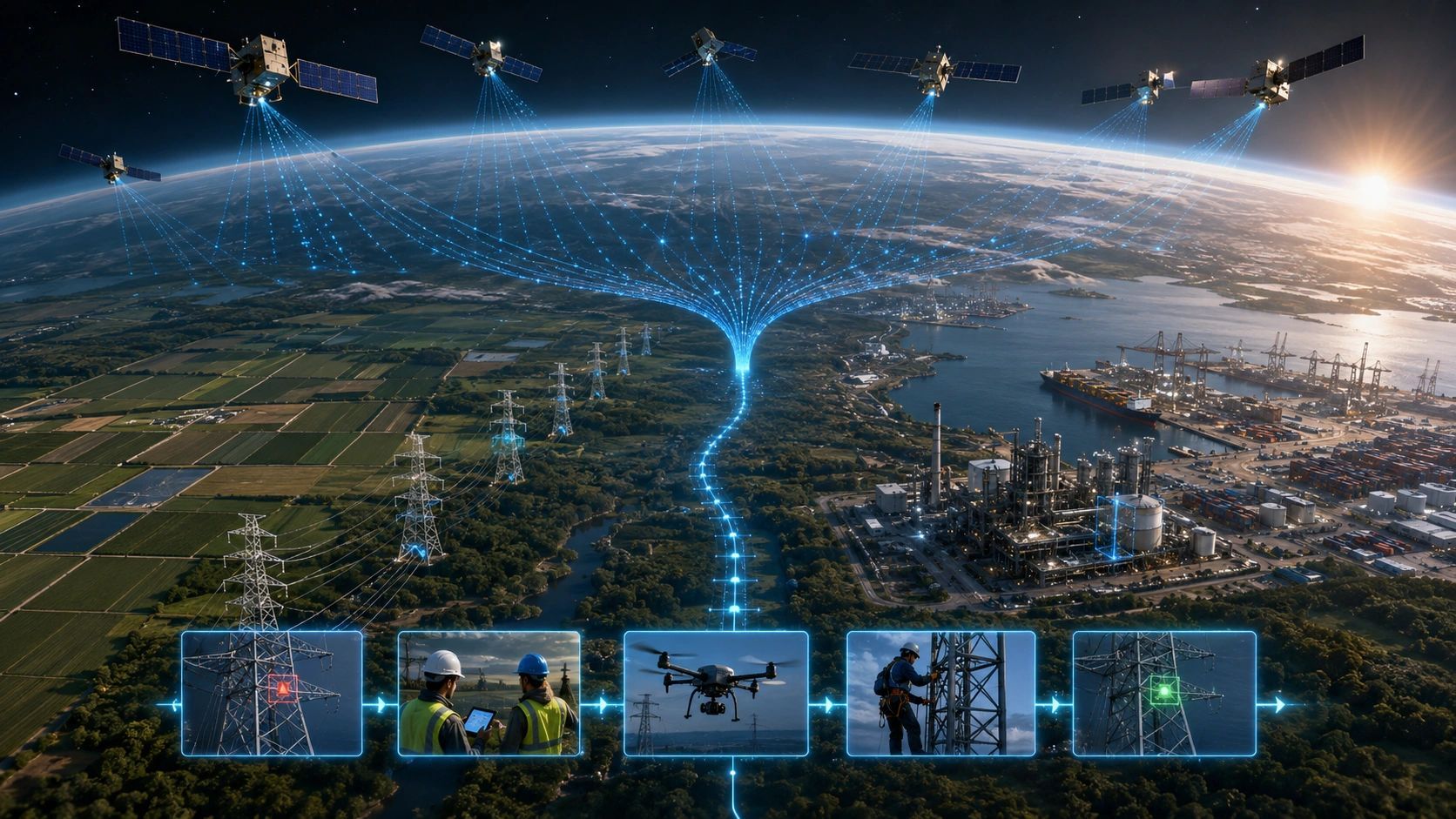
An observation may trigger a desktop review, UAV survey, field inspection, maintenance order, insurance assessment or emergency response.
The system should record who reviewed the evidence, what decision was made, what action was authorized and how completion will be verified.
A later satellite observation can then help determine whether the condition improved, persisted or worsened.
This closes the loop between sensing and outcome.
Why field verification remains essential
Greater satellite frequency will not remove the need for field evidence.
It may increase it.
Earth observation is powerful for detecting patterns across large areas, but some decisions require closer inspection. Cloud cover, vegetation, sensor resolution, observation geometry and the physical complexity of an asset can all affect interpretation.
A practical operating model should allow satellite observations to trigger targeted verification using UAVs, mobile mapping, IoT devices or human inspection.
This avoids two costly extremes: sending teams everywhere or trusting remote observations beyond their decision limits.
The value comes from directing the appropriate verification method to the right place at the right time.
Sector value comes from the decision loop
The same architecture can support very different sectors.
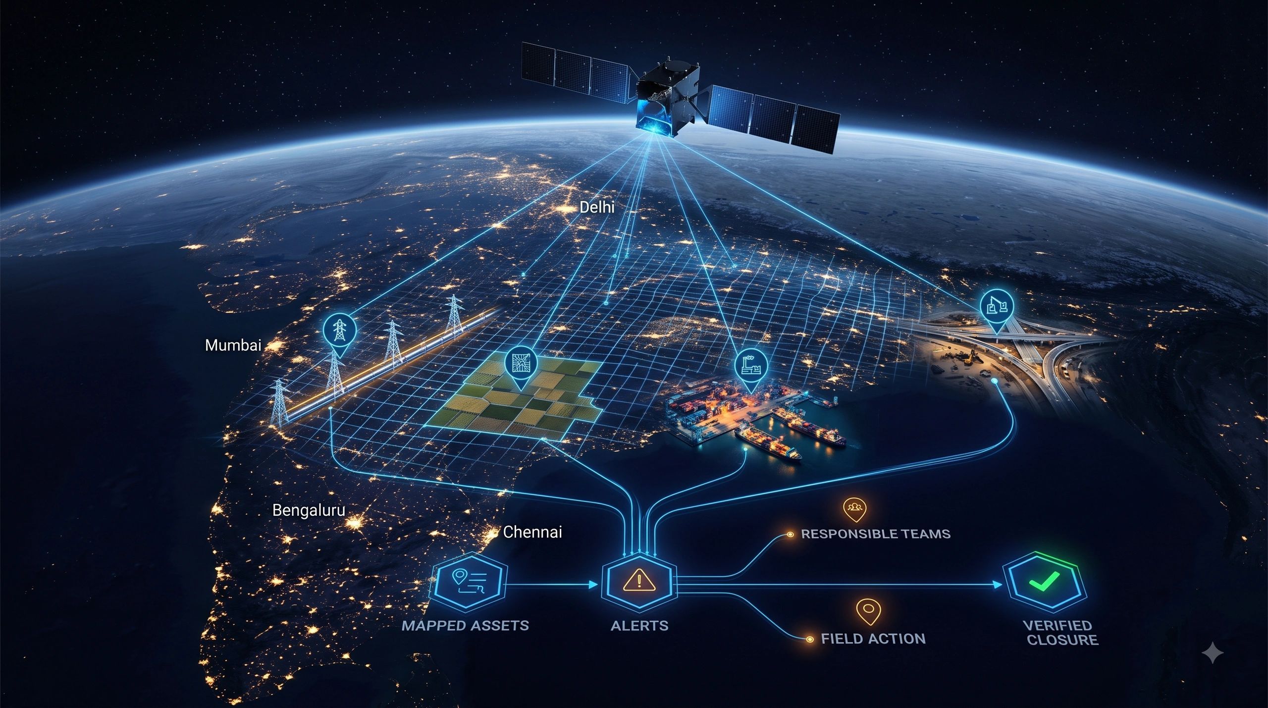
In utilities, it can connect vegetation or ground-movement signals to specific transmission lines, pipelines and maintenance teams.
In agriculture, it can connect crop-condition observations to field boundaries, irrigation decisions and evidence of intervention.
In mining, it can associate land disturbance, stockpile change or environmental conditions with permits and operational responsibilities.
For ports and infrastructure corridors, it can connect coastal change, congestion, encroachment or environmental observations with physical assets and concession obligations.
In insurance, the value is not simply viewing the affected region. It is linking an observed event to insured assets, exposure estimates, inspection priorities and claim evidence.
The technology differs across these applications, but the commercial question remains consistent:
What decision changes because this observation exists?
The partnership model is also changing
Constellation builders and sensor companies do not need to become enterprise workflow providers for every industry.
Likewise, geospatial integrators do not need to manufacture satellites to create value from the expanding observation layer.
A stronger partnership model divides responsibilities clearly.
The satellite provider delivers persistent and specialized observation. The operational intelligence partner connects those observations to customer assets, business rules, field teams and verification workflows. Domain specialists determine the thresholds, professional interpretation and authorized response.
For BSMA Enterprises and Dhineu, this creates a clear position between upstream sensing and downstream execution.
The opportunity is not to compete with constellation builders. It is to help organizations convert space-derived intelligence into governed operational decisions through geospatial integration, GeoAI, field verification and decision workflows.
The real measure of Earth observation maturity
The industry often measures progress through satellite count, revisit frequency, resolution and data volume.
These indicators matter, but enterprise maturity requires a different set of measures:
- How quickly was a relevant change identified?
- How accurately was it connected to the affected asset?
- Was the evidence current enough for the decision?
- How long did it take to assign responsibility?
- Was the intervention verified?
- Did the action reduce risk, cost or operational delay?
As satellite manufacturing scales, access to observation will become less distinctive by itself.
The differentiator will be the organization’s ability to convert observations into trusted decisions and trusted decisions into measurable outcomes.
The next Earth observation race may not be decided entirely in orbit.
It may be decided inside the operational workflows that determine whether anyone acts on what the satellites can see.