For decades, almost every modern spatial system has relied on one invisible dependency: GNSS.
Surveying equipment, drones, autonomous vehicles, mobile mapping systems, construction machinery, telecom networks and even financial systems depend on satellite-based positioning or timing.
That dependency works extremely well, until the signal disappears, gets blocked, is deliberately jammed, or worse, is spoofed.
This is why Quantum Positioning, Navigation and Timing (Quantum PNT) deserves attention.
But it also deserves careful framing.
Quantum PNT is not yet a magic replacement for GPS. It does not give us zero-drift navigation, unlimited centimeter accuracy underground, or perfect positioning for weeks beneath the ocean.
What is happening is more grounded and potentially more important.
Quantum navigation is beginning to move from physics laboratories into engineered navigation systems.
The problem is not positioning. It is trusted positioning.
GNSS works because a receiver continuously receives an external reference.
Remove that reference and autonomous systems fall back on inertial navigation.
An inertial measurement unit tracks acceleration and rotation and continuously calculates how a platform has moved.
The problem is drift.
Tiny measurement errors accumulate.
A drone flying through a tunnel, an autonomous vehicle operating inside a factory, or an underwater vehicle inspecting a pipeline may begin with an accurate position.
But as time passes without an external reference, uncertainty grows.
The challenge therefore is not simply:
Where am I?
It is:
How certain am I that I still know where I am?
That distinction becomes critical when autonomous systems start making decisions from spatial data.
This is where quantum sensing enters the picture.
One emerging approach uses atom interferometry.
Instead of relying only on conventional mechanical or optical inertial sensors, quantum inertial sensors use atoms as extremely stable references for measuring acceleration and rotation.
The attraction is clear.
Classical inertial sensors are fast, compact and mature but their biases accumulate.
Quantum sensors can provide extremely stable long-term references.
That combination creates an interesting possibility.
Not:
Quantum replaces the IMU.
But:
Quantum helps stop the IMU from slowly losing its sense of position.
And that is much closer to where implementation is heading.
The practical architecture will probably be hybrid.
The most credible Quantum PNT systems emerging today combine multiple sources:
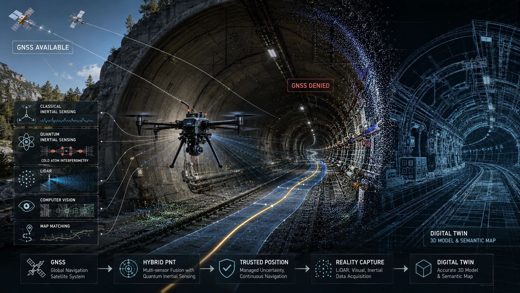
GNSS + classical inertial navigation + quantum sensing + maps + vision + magnetic navigation + terrain references + timing sources.
A sensor-fusion layer determines which sources can currently be trusted.
When GNSS is available, it contributes an absolute reference.
When GNSS disappears, inertial navigation continues.
Quantum sensing can help constrain long-term drift.
Vision, LiDAR, terrain matching, magnetic maps or signals of opportunity can provide additional corrections.
The result is not a completely independent navigation system.
It is a more resilient navigation system.
That distinction matters.
And this is no longer only theoretical.
Several real-world programmes show where the technology has reached.
India's National Quantum Mission (NQM) includes quantum sensing, atomic clocks and GPS-independent navigation as strategic technology areas.
Boeing and AOSense, Inc have flight-tested a quantum inertial measurement system aboard an aircraft.
The UK has conducted quantum navigation flight trials involving Infleqtion, BAE Systems and QinetiQ.
The Royal Navy has repeatedly tested cold-atom technologies at sea, including quantum timing and navigation systems.
In March 2026, ESA launched the PASQUALE programme to develop and validate a hybrid navigation architecture combining GNSS, conventional inertial sensing and cold-atom quantum sensing.
The UK has also placed quantum navigation deployment on aircraft within its national quantum strategy toward 2030.
These are important signals.
The question is no longer:
Can quantum physics measure motion accurately?
That has been demonstrated.
The question is now:
Can quantum sensors become small, robust, economical and reliable enough to operate inside real navigation systems?
That is the engineering challenge.
There are still major constraints.
Current quantum inertial systems can require sophisticated lasers, vacuum systems, optical components, magnetic shielding and highly controlled environments.
Size, weight, power consumption, cost and robustness remain significant barriers.
There are also system-level errors that quantum physics does not automatically eliminate.
A quantum sensor may have an extremely stable atomic reference, but the complete system still contains electronics, optics, mechanical structures, algorithms, calibration models and environmental dependencies.
That is why claims such as “zero drift” should be treated carefully.
Quantum sensing can dramatically reduce some forms of inertial error.
It does not eliminate uncertainty from an entire navigation stack.
Likewise, saying a quantum navigation system is “impossible to spoof” goes too far.
Quantum inertial measurements do not depend on external GNSS radio signals, so conventional GNSS jamming and spoofing do not affect them in the same way.
But software, sensor integration, reference maps, cyber systems and other components can still be compromised.
Quantum sensing removes one important vulnerability.
It does not remove the need for system integrity.
For geospatial systems, this may be the bigger opportunity.
Consider mobile mapping inside tunnels.
Today, maintaining accurate trajectories may require control points, SLAM, loop closure, surveyed references and other correction mechanisms.
A quantum-enhanced inertial system could potentially allow accurate navigation to continue for much longer before uncertainty becomes operationally unacceptable.
The same principle applies to:
- underground mines,
- large industrial facilities,
- autonomous construction equipment,
- subsea inspection,
- hydrographic mapping,
- defense environments,
- airports,
- warehouses,
- infrastructure corridors.
The immediate opportunity is therefore probably not:
“Remove all control points.”
It is:
“Reduce how often external correction is required.”
That alone could change many reality-capture workflows.
But there is another consequence for Digital Twins.
A Digital Twin normally stores position as if coordinates were facts.
X.
Y.
Z.
But autonomous systems increasingly need something richer.
A future spatial record may need to contain:
position + timestamp + navigation source + last trusted fix + accumulated uncertainty + sensor provenance + integrity status.
Because a coordinate is not equally trustworthy under all operating conditions.
A position derived from clear GNSS reception is different from one calculated after twenty minutes of inertial dead reckoning.
A position corrected by a trusted quantum reference is different again.
This means Quantum PNT may ultimately become part of a larger shift from location data toward location evidence.
That changes the Digital Twin conversation.
The future question may not be:
“Where is this asset?”
It may be:
“What evidence supports this position, how old is that evidence, and is it trustworthy enough for the next autonomous action?”
That is a very different way of thinking about spatial intelligence.
Quantum PNT is therefore worth watching not because GPS is about to disappear, and not because quantum sensors will suddenly make navigation perfect.
It matters because autonomous systems need positioning that remains dependable when their normal reference environment fails.
And as machines gain more authority to inspect, navigate, map and act in the physical world, position integrity may become as important as position accuracy.
Perhaps the real promise of Quantum PNT is not perfect navigation.
It is something more practical:
keeping spatial confidence alive after the satellite signal is gone.