A highway cannot be understood from its visible surface alone.
The pavement may be captured accurately, while the utilities beneath it remain uncertain. A drone can show current site conditions, but it cannot establish land ownership. A cadastral map can define parcel boundaries, yet reveal little about terrain, drainage or structural condition.
This is why integrated geospatial surveys are moving beyond the use of one preferred sensor.
The emerging model combines multiple forms of evidence to create a more complete and decision-ready representation of the corridor.
A 314-kilometre signal from India
A recent project in Haryana illustrates this transition.
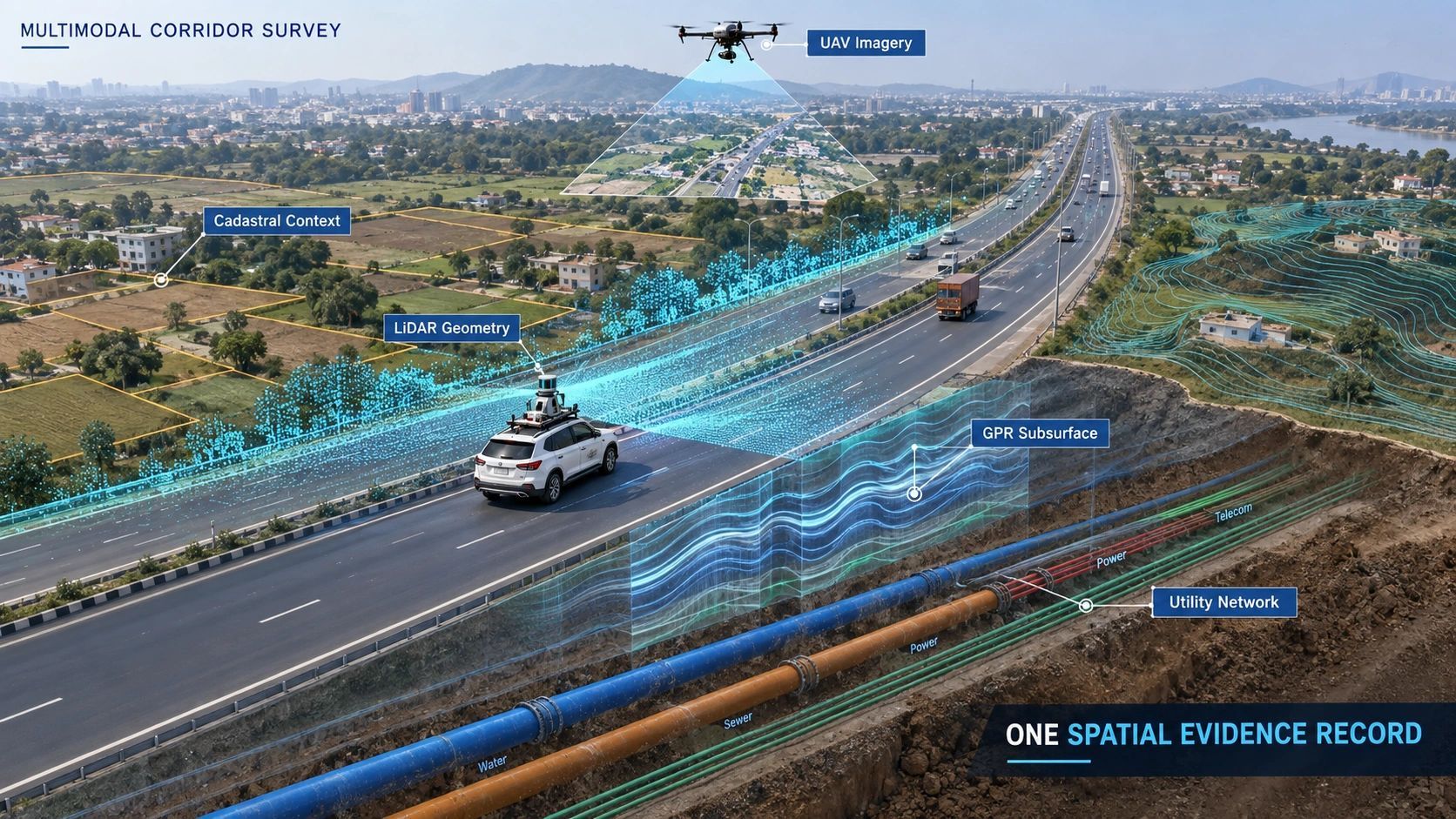
Matrix Geo Solutions completed a 314-kilometre geospatial survey for RITES and NHAI across highway corridors. According to the project information covered in my briefing, the programme combined:
- Aerial and mobile LiDAR
- UAV surveys
- Ground Penetrating Radar
- Cadastral digitization
- Topographic surveys
- Utility mapping
The contract was valued at approximately ₹28.26 million, and RITES issued the completion certificate on 21 August 2026.
One project does not establish an industry-wide standard. But the combination of technologies is an important signal.
Infrastructure owners increasingly need more than a map, point cloud or collection of photographs. They need different kinds of physical, operational and administrative evidence connected to the same location.
Every survey method sees a different reality
LiDAR can provide accurate surface geometry, elevation and structural form.
UAV imagery adds recent visual context, including site condition, encroachments, construction activity and surrounding land use.
Ground Penetrating Radar can reveal subsurface features that are invisible to cameras and surface scanners.
Topographic surveys establish terrain, levels and drainage relationships.
Utility mapping identifies the networks that may affect widening, excavation or maintenance.
Cadastral records introduce the parcel and right-of-way context required for land-related decisions.
None of these should be treated as interchangeable.
They answer different questions, carry different limitations and may have different levels of authority. Even cadastral information must be checked for source, date, scale and administrative status before it is treated as definitive evidence.
The value comes from connecting them without losing those distinctions.
The difficult part begins after capture
Multimodal capture does not automatically create an integrated survey.
A project can collect excellent data from five systems and still deliver five disconnected outputs:
- A point cloud in one folder
- Ortho-mosaics in another
- GPR profiles in specialist software
- Utility drawings as separate CAD files
- Parcel records in spreadsheets or GIS layers
The data may share a coordinate system and still fail to support a coordinated decision.
The real integration problem concerns identity, time and provenance.
Which LiDAR points belong to a specific bridge, culvert or road segment?
Which GPR anomaly intersects a proposed excavation zone?
Which utility record is authoritative, and when was it last verified?
Which parcel boundary was used when the right-of-way decision was made?
Which image proves the physical condition on a particular date?
Without these connections, multimodal surveying can produce more data without producing a stronger evidence chain.
The corridor segment should become the common reference
A better approach is to organize survey evidence around persistent corridor and asset identities.
Each road segment, structure, utility crossing, parcel interface and work package should have a stable reference. Every observation can then be connected to that reference while retaining its original source and timestamp.
The workflow becomes:
capture → spatial alignment → quality control → asset or segment identification → evidence linking → decision workflow → subsequent verification.
This changes the deliverable.
Instead of receiving a point-cloud archive and several specialist reports, the owner receives one spatial evidence record for every relevant corridor segment.
That record could connect:
- Surface geometry
- Pavement and roadside condition
- Underground observations
- Utilities
- Structures
- Parcels and right-of-way
- Design models
- Inspection findings
- Construction changes
- Maintenance history
The objective is not to force every dataset into one format. It is to make the relationships among them query-able and traceable.
The business value appears in downstream decisions
This integrated record can support several stages of the infrastructure lifecycle.
During DPR preparation, teams can examine terrain, structures, utilities and land constraints together rather than discovering conflicts later.
During land acquisition, corridor geometry can be connected to parcel information and right-of-way requirements.
During design, engineers can identify locations where widening, drainage or structural work may conflict with existing utilities.
During construction, the same evidence base can support machine guidance, progress verification and change management.
During operations, maintenance teams can compare current observations with earlier surveys and determine where conditions have materially changed.
The strongest commercial value may therefore sit beyond the original survey.
A multimodal survey creates a reusable infrastructure evidence base. If it remains current and governed, it can support multiple decisions instead of serving only one design or contractual milestone.
Capture companies and platforms have different roles
This change also creates a useful partnership model.
LiDAR, UAV, GPR and specialist survey providers do not all need to become software-platform companies. Their strength may remain high-quality capture, processing and technical interpretation.
A spatial data platform can sit above those providers and handle:
- Ingestion of different formats
- Spatial and temporal alignment
- Common asset identities
- Provenance and version tracking
- Cross-modal queries
- Connection to design and maintenance workflows
- Controlled access to evidence
This is closely aligned with the thinking behind our NeuSpatial platform and the planned S-MDIP capability: ingest multiple data types, normalize their spatial relationships and make the combined evidence usable in operational workflows.
The opportunity is not to replace specialist survey companies. It is to help their outputs retain value after individual files and reports have been delivered.
Integration must preserve uncertainty
Multimodal systems can also create false confidence.
A visually complete corridor model may combine information captured on different dates, at different resolutions and with different verification standards.
If those differences disappear inside a polished interface, the system becomes harder to trust.
Every observation should retain essential context:
- Who or what produced it
- When it was captured
- Where it applies
- How accurately it was positioned
- What processing it underwent
- Whether it was independently verified
- Which decision it is permitted to support
An underground feature inferred from GPR should not appear as certain as a physically exposed and surveyed utility. An old parcel record should not silently carry the same status as a recently validated boundary.
Integration should connect evidence, not flatten its uncertainty.
From survey deliverable to infrastructure memory
The direction is becoming clearer.
Infrastructure surveys are moving from isolated capture exercises toward connected evidence systems. LiDAR, UAV imagery, GPR, utilities, cadastral information and design data are increasingly valuable when they explain the same physical corridor together.
The competitive advantage will not come only from operating more sensors.
It will come from preserving the identity, timing, provenance and decision context of everything those sensors observe.
The next-generation survey deliverable will therefore be more than a map, model or point cloud.
It will be a governed spatial memory of the infrastructure, one that can be questioned, updated and used to support decisions throughout the asset lifecycle.