We have become remarkably good at digitizing what we can see.
Buildings can be laser-scanned.
Road corridors can be mapped by mobile LiDAR.
Construction sites can be captured daily by drones and cameras.
Assets can be represented in BIM and connected to operational GIS.
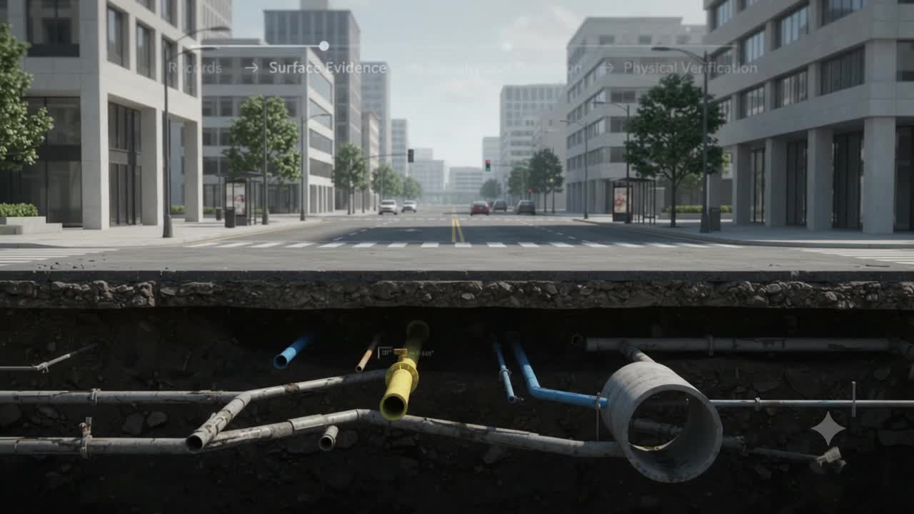
Yet beneath the same infrastructure lies another environment that is often represented by old drawings, approximate lines and institutional memory.
A water pipe may appear in GIS.
A telecom duct may appear on an as-built drawing.
A gas main may have coordinates.
But the question before excavation is much harder:
How certain are we that it is actually there?
That distinction may define the next stage of infrastructure digital twins.
The underground problem is not simply a mapping problem
Brownfield infrastructure projects regularly encounter utilities whose actual locations differ from historical records.
Some were moved during emergency repairs.
Some were installed before reliable digital surveying became standard.
Some abandoned assets remain underground but disappeared from documentation.
Others may be shown several meters away from their actual location.
The result is an unusual situation.
Above ground, infrastructure teams increasingly work with centimeter-level or even millimeter-level reality capture.
Below ground, critical decisions can still depend on a line drawn decades ago.
The source document describes this as an operational blind spot: subsurface assets are rarely incorporated into the master BIM or 3D GIS environment together with explicit measures of spatial uncertainty.
That matters because a buried utility is not just another dataset.
It may be a high-voltage cable.
A pressurized gas main.
A trunk water line.
A fiber corridor.
When excavation meets the wrong one, the consequence is not merely a mapping error.
It becomes a safety event, a construction delay and a financial liability.
3D GPR changes what can be observed
Traditional Ground Penetrating Radar surveys commonly produce individual radar profiles along selected lines.
Useful but still fragmented.
Multi-channel 3D GPR arrays change the acquisition model.
Instead of repeatedly pushing a single antenna across individual survey lines, arrays containing multiple antennas can collect dense, closely spaced radar observations during a continuous pass.
The result is closer to a volumetric representation of subsurface dielectric contrasts than a collection of isolated 2D radargrams.
Combined with RTK GNSS or total-station positioning, those reflections can be tied directly into project survey coordinates.
Surface LiDAR can provide the terrain reference.
Electromagnetic locating can supplement GPR for metallic utilities.
Other techniques can be introduced when soil conditions or utility characteristics make radar unreliable.
But this does not mean we suddenly have perfect underground vision.
And that distinction is important.
A digital twin should represent uncertainty, not hide it
One of the most dangerous things we could do is convert uncertain geophysical evidence into a beautifully precise 3D pipe model.
The geometry might look authoritative.
The evidence behind it may not be.
This is where standards such as ASCE 38-22 or IRC:SP:19-2020 become strategically important.
They provide quality classifications for subsurface utility information.
At a simplified level:
QL-D: information derived primarily from records or recollection.
QL-C: records correlated with surveyed surface features such as valves and manholes.
QL-B: utilities detected through surface geophysics such as GPR or electromagnetic locating.
QL-A: utilities physically exposed and surveyed to establish their precise position and attributes.
The important idea is not the label itself.
It is that confidence becomes part of the asset model.
A pipe is no longer simply represented as:
“Gas main at this coordinate.”
Instead, the system can understand:
“A probable gas main has been geophysically detected here, at this confidence level, with this positional uncertainty, but has not yet been physically verified.”
That is a very different digital twin.
Now connect that intelligence to BIM and GIS
This is where the concept becomes more interesting.
Imagine a proposed metro station, highway widening project or industrial brownfield redevelopment.
A 3D GPR survey identifies underground utilities across the corridor.
Those detections are transformed into georeferenced utility vectors.
Each asset carries more than geometry:
material,
diameter,
service type,
survey source,
quality level,
positional tolerance,
timestamp,
and engineering sign-off.
Verified utilities can then become structured digital as-built information aligned with IRC principles and connected into BIM and 3D GIS environments.
Now the BIM model knows where the proposed pile foundations are.
The GIS knows the underground utility network.
The survey system knows how confidently each utility has been located.
The decision system can finally ask a much more useful question:
Where does design uncertainty create unacceptable construction risk?
This creates a different workflow
Consider a two-kilometer urban infrastructure corridor.
The GPR array surveys the alignment.
Processing identifies probable underground utilities.
The detections enter the 3D GIS with their corresponding quality levels.
The proposed foundation design is overlaid.
Most utilities create no conflict.
But four proposed piles intersect a suspected gas main.
The gas main is only QL-B.
The system should not conclude:
“Move the entire foundation design.”
Nor should it conclude:
“The model says the pipe is here, so drilling is safe elsewhere.”
Instead, it should ask:
What additional evidence is required before this specific decision can be authorized?
Only those four locations may need targeted QL-A verification.
Vacuum excavation exposes the utility.
Surveyors measure its actual position and dimensions.
The digital twin is updated.
The uncertainty collapses.
The construction decision can proceed.
This is where subsurface digital twins move beyond visualization.
They become part of risk-based evidence escalation.
There are still physical limits
GPR is not underground X-ray vision.
Wet clay and saline soils can strongly attenuate radar signals.
Dense reinforcement can create severe scattering.
Congested corridors generate ambiguous reflections.
Depth estimation depends on assumptions about material properties.
Some utilities require complementary locating technologies.
The source notes that high-conductivity soils can significantly reduce practical GPR penetration and that reinforced urban environments may require specialized processing and additional electromagnetic tracing.
So the goal should not be:
“Create a perfect underground model.”
The more realistic goal is:
Create an underground evidence model that clearly distinguishes what is known, inferred, detected and verified.
The GeoThinking shift
Perhaps the most important development here is not better radar.
It is a change in what we expect from spatial information.
Traditional GIS often asked:
Where is the asset?
Subsurface digital twins need to ask:
Where do we believe the asset is?
How was that belief established?
How uncertain is its position?
What decision depends on it?
And what additional observation would reduce that uncertainty enough to act safely?
That changes the role of the digital twin.
It is no longer simply a digital representation of underground infrastructure.
It becomes an evidence system for physical decisions.
And as autonomous machines, excavation systems and AI-assisted construction workflows enter infrastructure operations, that distinction becomes even more important.
Because machines will eventually need more than coordinates.
They will need to understand whether those coordinates are trustworthy enough to act upon.
The underground may never become completely visible.
But it can become observable, qualified and progressively verified.
And that may be far more valuable than pretending we know exactly what lies beneath our feet.