A utility drone is cleared to inspect a transmission corridor. It stays inside its geofence. Then its camera turns toward a neighboring industrial site, or its inspection software flags an asset that belongs to another operator.
The aircraft may be exactly where it is allowed to fly. That does not answer whether it is allowed to collect that image, inspect that asset, share the observation, or trigger a maintenance task.
As drone operations scale, “Where may it fly?” becomes only the first permission question.
A boundary cannot describe a mission
Geofences serve a clear purpose. They can help keep an aircraft out of a restricted area or within a planned operating boundary. Airspace authorization is another essential layer. In the United States, for example, the FAA says its LAANC system provides airspace authorizations, while operators must still check other restrictions and operating conditions. Europe’s U-space framework separately provides geo-awareness, network identification, traffic information and flight authorization in designated airspace. faa.gov
These systems address aviation questions. An infrastructure owner faces additional questions inside the authorized airspace.
Which drone is assigned to this job? Which organization controls it? Is it inspecting the correct asset? Can it record video, use thermal imaging, or only collect a specified measurement? Who can receive the result? What happens if conditions change halfway through?
A polygon on a map cannot answer those questions by itself.
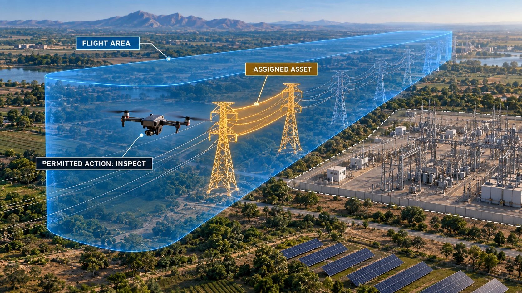
Consider a solar farm beside a substation. A drone may have permission to fly over the site for panel inspection between 10:00 and 11:00. Its operator may have access to the solar assets but no authority to inspect the substation. A thermal anomaly detected near the boundary might be useful information, yet usefulness does not grant permission to investigate, distribute or act on it.
That is the gap spatial permissions must close.
Permission needs more than coordinates
For an autonomous mission, I would describe permission as a relationship between eight things:
Aircraft or agent → operator → mission → place → time → target asset → permitted action → evidence and outcome.
Each element changes what the system may do.
The place should describe a three-dimensional operating volume where relevant, with a valid time window. The target asset should have a reliable identity, rather than merely appear as a shape on a map. The permitted action might be “capture imagery,” “measure vegetation clearance,” or “raise an issue for human review.” Those are different authorities.
The mission record should also specify conditions that can suspend or narrow permission: an expired approval, a temporary airspace restriction, a lost connection, uncertain positioning, a changed asset boundary, or an aircraft that fails a required health check. How each condition affects flight must follow the applicable operating rules and approved procedures.
This is an architectural proposal for enterprise operations, not a claim that a new regulatory permission category already exists. Civil aviation approval remains with the relevant authority. A company’s spatial permission layer would sit alongside that process and govern what its own systems, people and machines are allowed to do.
The asset model becomes part of the safety case
Here is where geospatial information becomes operationally important.
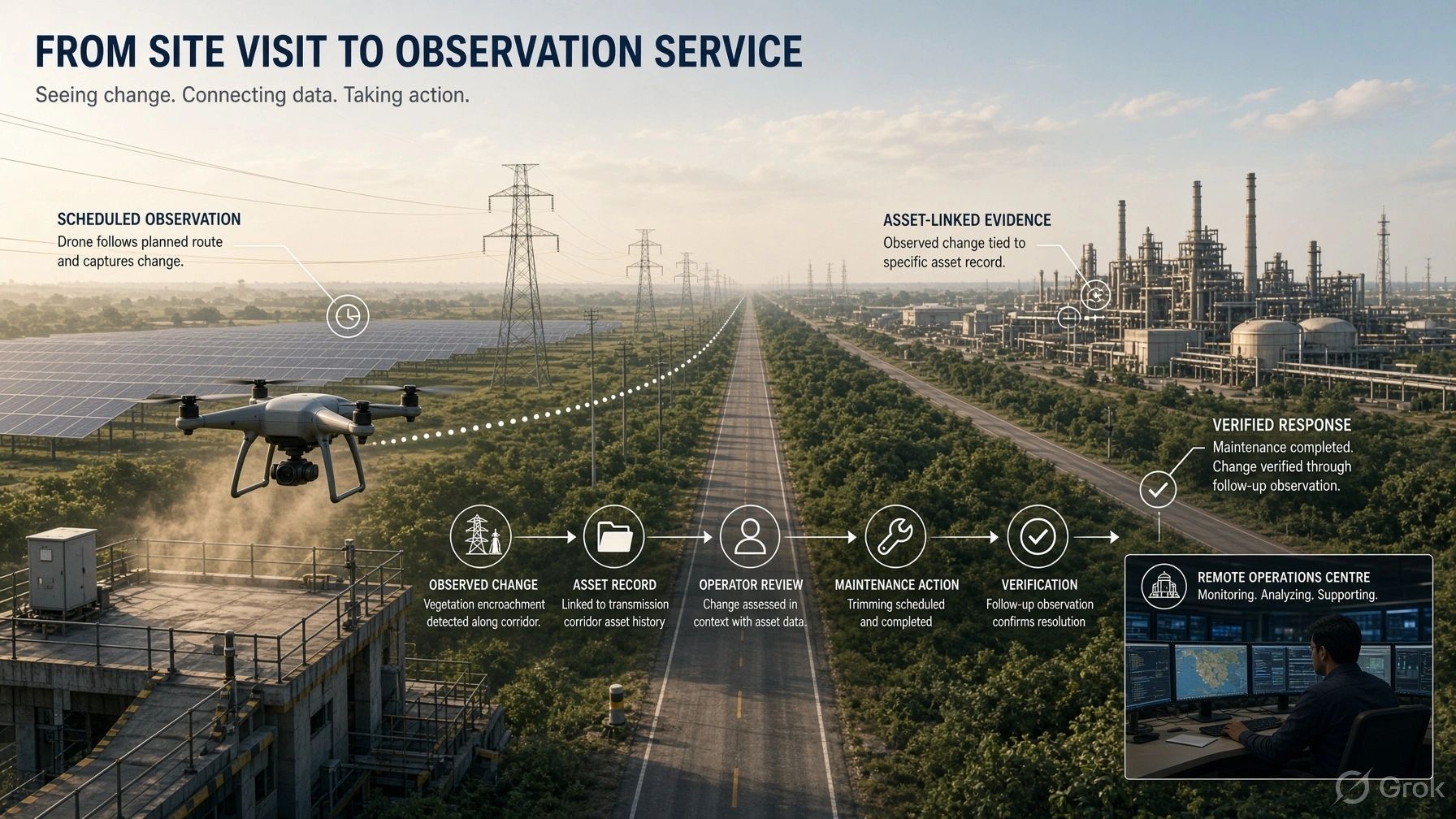
Suppose a drone detects vegetation close to a power line. To turn that observation into a work order, the system needs to know which span it observed, how that span is represented in the asset register, when the location was last verified, and whether the observation meets the operator’s inspection criteria.
If the line geometry is stale, the drone can be in the right corridor and still associate the finding with the wrong span. If asset ownership changes at a boundary, an automatically routed work order could reach the wrong organization.
A useful spatial permission system therefore depends on more than precise positioning. It needs dependable asset identity, current boundaries, versioned mission instructions and an evidence trail connecting each observation to its source.
That evidence trail should make it possible to reconstruct a decision:
- What was the aircraft authorized to do?
- Which map and asset records did it use?
- What did it observe, and with what confidence?
- Which action did the system take?
- Who reviewed an exception?
These records matter most when an operation goes wrong. They also make routine inspections easier to verify and improve.
Start with a narrow mission
An organization does not need to build a universal drone operating system to apply this idea. A repeatable inspection route is enough to expose the practical requirements.
Take a utility corridor inspection. Before launch, the operator links the aircraft and crew to a mission, the current flight approvals, an operating volume, a time window and a defined set of line assets. The mission specifies which observations may be collected and which findings can be drafted as issues.
During flight, the system checks whether the mission remains within those conditions. If the drone detects something outside its assigned assets, it can retain a limited exception record and route it for human review under the operator’s policy, instead of automatically creating a maintenance instruction.
After landing, each accepted observation is linked to an asset and the mission evidence. A reviewer can see why a vegetation issue was raised and whether it falls within the work the drone was authorized to perform.
The benefit is practical: fewer ambiguous findings, clearer responsibility and a stronger path from inspection to action. It also gives owners a way to compare the performance of repeated missions without losing the context behind each result.
The next scaling constraint is authority
India’s Digital Sky platform already provides an airspace map, and its published API documentation describes a way to check whether a planned flight area intersects red or yellow zones. That is useful airspace information, but an enterprise still has to connect an authorized flight to its own assets and work rules. digitalsky.dgca.gov.in
The same distinction applies whether a team flies one aircraft or manages fleets across utilities, mines, construction sites and farms. At small scale, an experienced operator may hold much of the mission context in their head. At larger scale, that knowledge must be explicit, current and available to the systems coordinating the work.
My view is that spatial permission will become a core part of autonomous operations. It will determine the scope of an aircraft’s work and preserve the reason an observation became a decision.
A geofence can tell a drone that it has reached a boundary. A trusted mission record can tell the organization whether the drone was authorized to do what it did there.
As autonomous inspections move from pilots to routine operations, the permission to fly must connect to the authority to observe and act.