
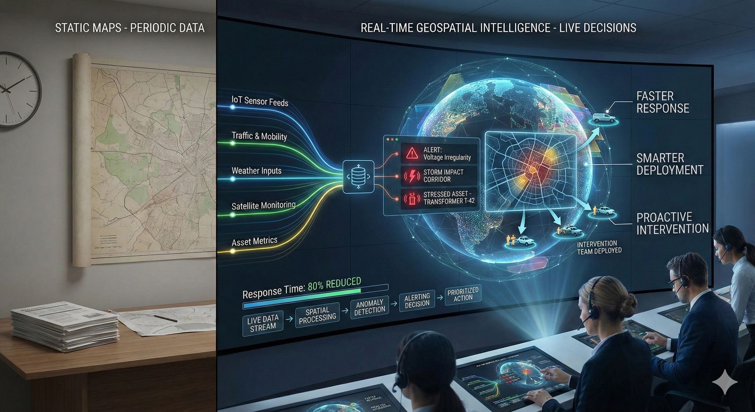
A map created last quarter may already be obsolete.
Traffic patterns shift daily.
Weather systems evolve hourly.
Assets degrade continuously.
Demand fluctuates in real time.
If decisions depend on static snapshots, organizations react late.
The advantage now lies in seeing change as it happens.
The real decision behind operational visibility
Across utilities, logistics, infrastructure, agriculture, and city management, leaders increasingly ask:
- What is happening right now?
- Where is disruption forming?
- Which assets require immediate intervention?
- How do we allocate resources dynamically?
Traditional GIS outputs are often periodic, monthly reports, annual reviews, static dashboards.
But operational environments are dynamic.
The challenge is no longer data availability.
It is decision latency.
Why real-time location intelligence changes operations
Real-time geospatial intelligence integrates:
- IoT sensor feeds
- Traffic and mobility data
- Weather inputs
- Asset performance metrics
- Field updates
- Satellite monitoring
Instead of analyzing historical patterns, organizations see spatial change in motion.
The question shifts from:
“What happened?”
To:
“What is forming, and where should we act now?”
That shift reduces response time dramatically.
From data to decision: the live intelligence flow
A real-time geospatial framework typically follows:
Live data streams → spatial processing → anomaly detection → alerting → decision intervention
This approach transforms dashboards from descriptive tools into operational command systems.
The output is not just visualization.
It is prioritized action.
A practical scenario
Consider a power distribution utility managing a large urban network.
With static reporting, outage response is reactive.
With real-time geospatial intelligence:
- Sensor feeds detect voltage irregularities
- Weather overlays predict storm impact corridors
- Asset performance data flags stressed transformers
- Service coverage maps show high-impact zones
Intervention teams are dispatched before cascading failures occur.
Downtime reduces, not because infrastructure changed overnight, but because awareness improved.
Business and operational impact
Organizations leveraging real-time geospatial systems often see:
- Faster incident response
- Reduced operational downtime
- Smarter workforce deployment
- Improved asset lifespan
- Enhanced customer satisfaction
The real gain is speed with context.
Where operational systems often fall short
Common gaps include:
- Dashboards without spatial prioritization
- Data overload without actionable filtering
- Sensor data disconnected from geographic context
- Alerts that lack impact ranking
Real-time data alone does not create intelligence.
Spatial context converts signals into decisions.
Scaling live intelligence into enterprise systems
Leading organizations integrate real-time geospatial dashboards with:
- Digital twins
- Enterprise asset systems
- Field workforce platforms
- Risk management tools
This builds operational ecosystems where location is continuously factored into decisions.
Operations become adaptive rather than reactive.
The monetization bridge
As operations scale, manual monitoring becomes impractical. Organizations increasingly seek structured advisory approaches and scalable spatial decision platforms that integrate live data streams into unified command views, ensuring decision speed keeps pace with system complexity.
Looking ahead
With AI-driven anomaly detection, predictive analytics, and autonomous response systems, real-time geospatial intelligence will move from alerting humans to guiding automated interventions.
The next evolution will not be just dashboards.
It will be self-optimizing spatial systems.
Closing insight
Speed matters.
Context matters more.
Real-time advantage comes from knowing not just what is changing, but exactly where it is changing.