Opening Reflection
We often speak about building a digital representation of the world.
We map cities, model buildings, monitor farms, simulate factories, and create digital twins of roads, utilities, and infrastructure networks. Yet the moment the physical world disappears beneath the water, our digital visibility weakens.
The ocean is frequently represented as a blue surface on a map.
But beneath that surface lies another landscape, one containing energy infrastructure, communication cables, pipelines, ports, foundations, ecosystems, and changing terrain.
The question is no longer whether we can map the land.
It is whether our idea of a digitally connected world can extend below the waterline.
Context: The Digital Blind Spot Beneath the Water
The ocean covers most of the planet, but it remains one of the most difficult environments to observe consistently.
Many conventional reality-capture technologies perform well on land but struggle when they encounter water. Standard UAV LiDAR and photogrammetry may capture the water surface, but they generally cannot reveal the submerged terrain and infrastructure below it. This leaves ports, offshore wind farms, coastal structures, rivers, and underwater pipelines within a fragmented digital environment.
This creates a serious limitation.
A port authority may have an accurate model of the terminal buildings, cranes, roads, and warehouses, but only periodic information about the seabed beside them.
An offshore wind operator may continuously monitor the turbine above the water, while the condition of its underwater foundation is examined through separate surveys.
A coastal planner may model the land in detail, but rely on incomplete bathymetric information to understand how storm surges and floodwater will move.
The infrastructure is physically connected.
The data is not.
The Technological Shift: Mapping Across the Waterline
Topo-bathymetric LiDAR offers a way to reduce this separation.
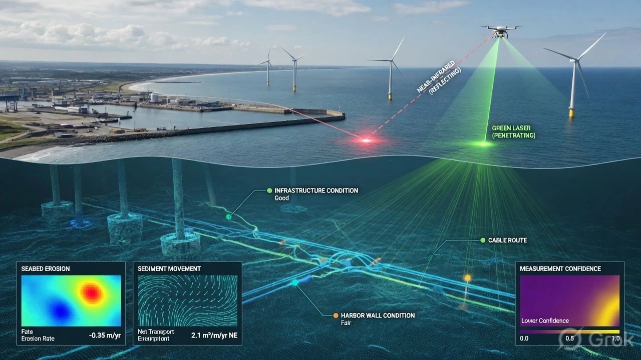
Unlike standard terrestrial LiDAR, which typically uses near-infrared light, topo-bathymetric systems combine different laser wavelengths.
A near-infrared beam measures the water surface. A green laser beam can pass through the water column and return from the seabed or submerged objects. By analyzing these returns, the system can generate a more continuous representation of the land, water surface, and underwater terrain.
This is more than an improvement in surveying.
It changes the boundary of the digital model.
Instead of treating the coastline as the edge of the dataset, we can begin treating it as a transition between connected environments.
A single spatial model can represent the road approaching a port, the terminal infrastructure, the retaining wall, the water surface, and the seabed around the structure.
That continuity is important because physical systems do not recognize the administrative boundaries of our software platforms.
Water flows across them.
Erosion develops beneath them.
Sediment moves through them.
Infrastructure failure can begin in an area that is rarely visible to the people responsible for decisions above the surface.
The Deeper Question: What Does It Mean to Make the Ocean Visible?
A digital twin is often described as a representation of a physical asset.
But representation alone is not enough.
A useful subsea digital twin must show how the underwater environment is changing over time. It must connect observations from different periods, identify deviations, and help people understand whether the change is natural, operational, or dangerous.
This raises a deeper question:
Are we digitizing the ocean simply to see it, or to become more accountable for what happens within it?
The Blue Economy includes offshore energy, shipping, ports, fisheries, coastal tourism, marine infrastructure, environmental protection, and emerging ocean industries.
Growth in these sectors will place greater pressure on environments that are already difficult to inspect.
Without persistent spatial intelligence, development may move faster than our ability to understand its effects.
Subsea digital twins therefore should not become tools that only make offshore development easier.
They should also make underwater change more measurable, visible, and governable.
The Spatial Intelligence Perspective
Spatial intelligence begins by understanding relationships.
A subsea model must not view the seabed as an isolated surface. It must connect underwater conditions with the assets, activities, and environmental processes surrounding them.
Consider an offshore wind turbine.
The tower, blades, gearbox, and power output may already be monitored through sensors and maintenance systems. But the foundation interacts with currents, sediment movement, waves, and seabed erosion.
If material around the foundation is removed by water movement, a process known as scour—the structural risk may increase even though the equipment above the water appears to be functioning normally.
Repeated bathymetric surveys can create a temporal model of this change. Instead of comparing disconnected reports, operators can observe how the seabed is evolving around the asset and decide when inspection or intervention is required. The concept note identifies this type of temporal monitoring as an important use case for offshore wind digital twins.
The same principle applies to pipelines, bridge foundations, harbor walls, dredged channels, coastal defenses, and undersea cables.
The value does not come from producing another 3D model.
It comes from connecting location, condition, time, consequence, and action.
Real-World Implications
For ports and coastal engineering, land-to-water modelling can support more integrated planning.
A port expansion project could use a continuous spatial dataset covering the dry dock, shoreline, retaining structures, shallow water, and seabed. Engineers could use that information alongside BIM and GIS to plan construction, estimate dredging requirements, monitor sediment movement, and assess structural conditions.
For climate resilience, the same datasets could improve hydrological and coastal simulations.
Flood routing and storm-surge models depend heavily on terrain. When land elevation and underwater bathymetry are captured separately, differences in resolution, date, and accuracy can weaken the model.
A more continuous dataset can provide a stronger foundation for understanding how water may move across the coastal boundary.
For offshore energy, subsea digital twins can support inspection planning, foundation monitoring, cable-route assessment, and long-term asset management.
For environmental management, repeated surveys could help identify seabed disturbance, erosion, sediment accumulation, or changes around sensitive marine areas.
Across these applications, the emerging opportunity is the same:
Move from occasional underwater surveys to a connected history of underwater change.
The Physical Limitation We Cannot Ignore
Technology does not remove the physics of water.
Green laser energy weakens as it travels through the water column. Suspended particles scatter the signal, while attenuation reduces its strength. Water clarity, depth, surface conditions, vegetation, and seabed characteristics all influence what can be detected.
This means topo-bathymetric LiDAR is not a universal replacement for sonar, divers, remotely operated vehicles, or vessel-based surveys.
Different environments will require different combinations of technologies.
The digital twin must therefore also communicate uncertainty.
It should show when the seabed was observed, which sensor produced the measurement, where coverage is incomplete, and how confident the system is in the detected change.
A visually complete model can still contain important gaps.
The purpose of spatial intelligence is not to hide those gaps. It is to make them visible enough to guide responsible decisions.
GeoThinking Insight
The next phase of digital transformation will not be defined only by how much of the world we can model.
It will be defined by whether we can connect environments that have traditionally been managed separately.
Land and water.
Surface and subsurface.
Infrastructure and ecology.
Development and responsibility.
Subsea digital twins represent more than a new market for surveying and visualization. They represent a change in how we think about the planet’s operational geography.
The ocean is not the space between landmasses.
It is infrastructure, habitat, climate system, economic network, and shared resource.
A Blue Economy that depends on the ocean must also invest in understanding how the ocean is changing.
Closing Reflection
For centuries, the waterline acted as a boundary to visibility.
What happened beneath it was difficult to observe, expensive to measure, and easy to separate from decisions made on land.
That boundary is beginning to weaken.
Topo-bathymetric LiDAR, sonar, underwater robotics, environmental sensors, GIS, BIM, AI, and digital twins can gradually create a more connected view of coastal and subsea environments.
But making the ocean digitally visible also creates a responsibility.
Once change can be measured, it becomes harder to ignore.
The real promise of subsea digital twins is therefore not simply that we will see more beneath the surface.
It is that we may learn to make better decisions because of what we can finally see.
As the Blue Economy expands, will subsea digital twins primarily accelerate development or help ensure that development remains accountable to the ocean itself?