
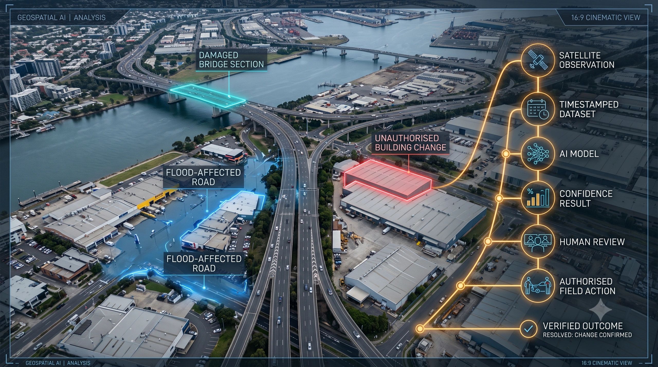
A spatial AI system detects an illegal structure with 94% confidence.
Is that enough to issue a notice?
A model identifies a damaged roof after a storm.
Is that enough to approve an insurance claim?
An Earth-observation system detects a methane plume.
Is that enough to trigger an enforcement action?
In each case, accuracy matters. But accuracy alone does not make the result decision-ready.
Before acting, an organization must understand the evidence behind the conclusion, the rules applied, the people involved and what happened next.
That requires something more than an accuracy score.
It requires a Spatial AI Evidence Record.
Accuracy answers only one question
Most GeoAI systems are evaluated through technical measures: precision, recall, false positives, false negatives and overall accuracy.
These metrics help determine whether a model performs reliably across a test dataset. They do not establish whether a specific operational decision was justified.
A model can be accurate overall while producing a poor result in one location because:
- the imagery was outdated;
- cloud, shadow or seasonal variation affected the observation;
- the asset boundary was incorrectly mapped;
- the model was used outside its intended geography;
- a confidence threshold was changed;
- an unapproved dataset entered the workflow;
- the output was never reviewed by a qualified person.
A single confidence score hides these conditions.
For an analyst, the score may be useful. For an asset owner, regulator, insurer, emergency commander or municipal authority, it is only one part of the decision.
The governance environment is changing
The EU AI Act became broadly applicable on 2 August 2026, although the requirements for high-risk systems listed in Annex III now apply from 2 December 2027, while rules for high-risk AI embedded in regulated products apply from 2 August 2028. Classification still depends on the system’s intended purpose and deployment context. European Commission
Not every geospatial AI application will be classified as high-risk. However, the direction is clear.
Where AI influences infrastructure, public services, safety, employment, environmental enforcement or access to essential services, organizations will need stronger controls around data governance, technical documentation, monitoring and human oversight.
Even outside regulated high-risk categories, the same controls are becoming commercially important.
Clients will increasingly ask:
- Where did this result come from?
- Can we reproduce it?
- Who reviewed it?
- Was that person authorized to approve the action?
- Can the finding withstand an audit, dispute or insurance review?
Governance is therefore becoming a product requirement, not an administrative appendix.
The operational chain matters more than the isolated prediction
Greece’s national wildfire capability illustrates this shift.
Four dedicated thermal satellites were launched in May 2026 as part of the Hellenic Fire System. The constellation connects thermal observation with a Greek ground station and an operational wildfire platform used by the country’s emergency services. European Space Agency, OroraTech
Its value does not come only from identifying a heat signature.
The useful chain is:
Detection → validation → prioritization → authorized response → field action → continued monitoring
Every stage changes the status of the evidence.
A thermal anomaly is not automatically a confirmed wildfire. A validated fire is not automatically the highest response priority. A dispatched team still needs field observations. The eventual outcome must be recorded so that both the incident and the system’s performance can be reviewed.
The same logic applies elsewhere:
- flood extent → exposed assets → road closure → inspection → reopening;
- ground movement → affected structure → engineering review → intervention;
- crop stress → farm identification → field verification → advisory;
- methane detection → source attribution → operator notification → remediation;
- asset anomaly → work order → repair → restored-performance verification.
Spatial AI creates value when its output enters a governed operational workflow.
What a Spatial AI Evidence Record should contain
A Spatial AI Evidence Record would accompany every material AI-generated spatial conclusion.
It should capture eight elements.
1. The question
What event, query or operational trigger initiated the analysis?
“Identify buildings constructed after the approved baseline” is more precise than “detect change.”
2. The approved evidence
Which satellite image, UAV survey, sensor stream, BIM model, field record or administrative dataset was used?
The record should retain its source, capture time, spatial coverage, resolution, license and integrity status.
3. The model
Which model and version produced the result?
This should include the intended use, relevant validation context and known limitations. If the model changes later, the original result must remain connected to the version that produced it.
4. The result
What exactly did the system detect, predict or recommend?
The output should carry a location, timestamp, confidence measure and supporting geometry, not simply a dashboard notification.
5. The rules
What threshold, business rule or policy converted the model output into an operational finding?
A building change with 70% confidence may be routed for review. The same change above 95% may receive higher priority. Those rules should be visible.
6. Human review
Who reviewed the finding, what evidence did they consider and did they accept, reject or modify the AI result?
Human oversight should be an accountable step, not a generic statement that a person was “in the loop.”
7. Authority and action
Who was authorized to issue the notice, close the road, deploy the inspection team, approve the claim or initiate the intervention?
Detection and authority are separate functions.
8. Outcome evidence
What happened after action was taken?
Field photographs, updated imagery, sensor readings, inspection results and restored-performance measures should close the record.
This converts the AI output from a temporary prediction into an auditable decision history.
The evidence record should not become another disconnected report
The wrong approach would be to generate a PDF after every analysis and store it in a separate compliance folder.
The evidence record must remain connected to the spatial object and operational workflow.
A road segment should retain the imagery that triggered an inspection, the model that detected the defect, the engineer’s review, the resulting work order and evidence that the repair restored the required condition.
A digital twin should therefore represent more than the current state of an asset. It should preserve the chain through which that state was observed, interpreted, approved and changed.
This is where GeoAI, digital twins, workflow systems and evidence governance begin to converge.
Evidence creates business value beyond compliance
A strong evidence record can reduce repeated inspections, shorten dispute resolution and make third-party validation easier.
It can also improve the AI system itself.
When an organization records which alerts were accepted, rejected or corrected—and what was found in the field, it creates structured feedback for model monitoring and retraining.
The evidence record therefore serves three purposes:
- Assurance: Can the decision be explained and defended?
- Operations: Can the right person act on it without reconstructing the context?
- Learning: Can the outcome improve future models, thresholds and procedures?
This is particularly important for municipal GIS, infrastructure inspection, disaster response, agriculture, carbon MRV and environmental monitoring, where spatial conclusions may affect money, safety, rights or regulatory obligations.
The next advantage will be defensibility
Spatial AI providers will continue competing on resolution, speed, automation and model performance.
Those capabilities will remain important. But as GeoAI moves deeper into operational decisions, another measure will matter:
Can the platform show why an important conclusion was reached, who approved the next step and whether the intervention worked?
The strongest spatial AI system will not simply produce the most confident answer.
It will preserve the evidence required to trust, challenge, act on and learn from that answer.