
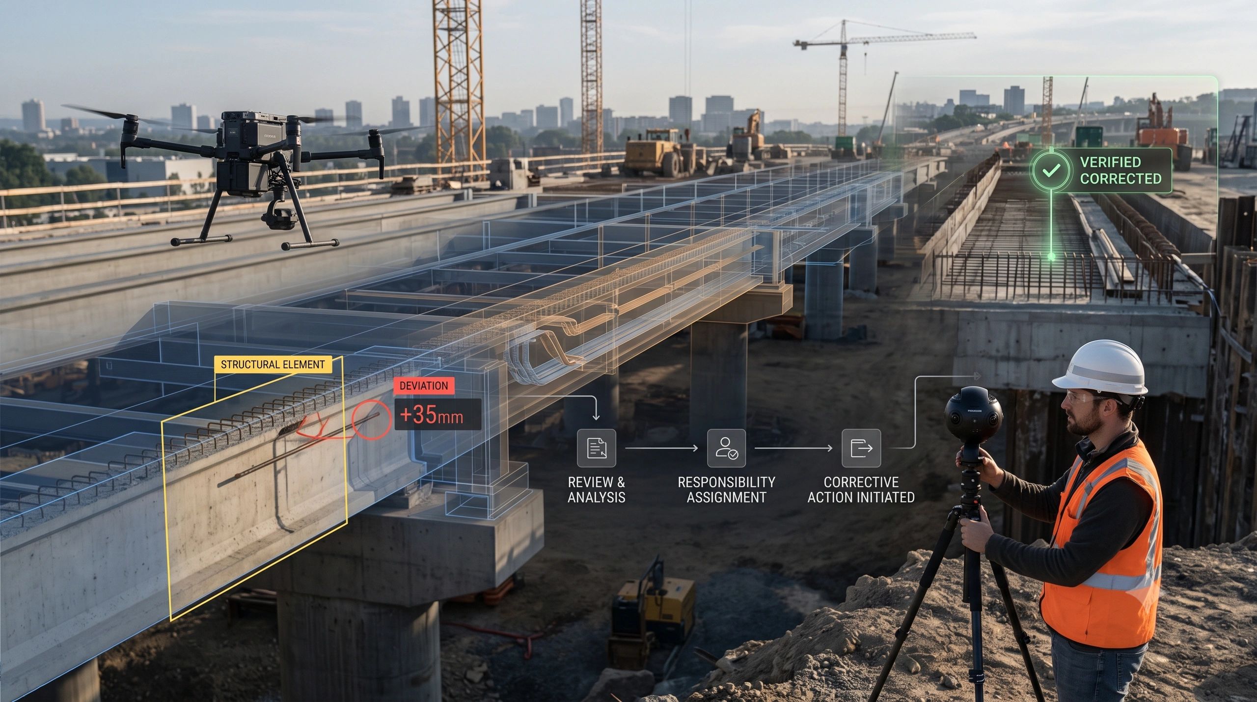
For years, reality capture has helped organizations see what is happening in the physical world.
Drones survey construction sites. Mobile cameras record roads. Robots inspect industrial facilities. Fixed cameras monitor progress. LiDAR and 360-degree systems document buildings and infrastructure.
Yet much of this information still ends its journey as a map, point cloud, model, image archive, dashboard or inspection report.
The organization can see the condition. But the condition does not automatically enter the workflow where someone must evaluate it, accept responsibility, take action and prove that the issue was resolved.
That is beginning to change.
Reality capture is evolving from a documentation tool into the trigger layer for enterprise action.
Capturing a condition is not the same as managing it
Consider a drone survey that detects incomplete work on a construction site.
The observation may be technically accurate. It may even be spatially linked to the building model. But several questions remain:
- Which work package does it affect?
- Is the observed difference material?
- Which contractor is responsible?
- Does it require immediate intervention or professional review?
- Who has the authority to accept the finding?
- What evidence will prove that the work was corrected?
If the system cannot answer or route these questions, it has produced better visibility not operational control.
The real value begins when a physical observation is connected to project intent, responsibility and an authorized next step.
The market is connecting capture with project management
Procore’s proposed acquisition of DroneDeploy is an important signal.
DroneDeploy brings data from drones, robots, mobile devices, fixed cameras and wearables. Procore operates where construction teams manage drawings, RFIs, inspections, submittals and project decisions.
The strategic value is not simply the addition of more imagery to a construction platform. It is the ability to connect what cameras observe with what project records say should exist.
This changes the operating model from:
Capture → process → report
to:
Capture → compare → identify exception → assign action → verify resolution
Under this model, reality capture is no longer a periodic survey deliverable. It becomes a recurring source of operational evidence.
The critical connection is between intent and reality
Every major asset or infrastructure programme operates with two versions of truth.
The first is approved intent:
- BIM models;
- drawings and specifications;
- schedules;
- work packages;
- maintenance standards;
- contractual obligations;
- environmental conditions and permits.
The second is observed reality:
- actual site progress;
- installed equipment;
- asset condition;
- defects and deviations;
- environmental change;
- safety conditions;
- evidence of completed work.
Most digital systems are stronger on one side than the other. Design and project platforms manage intent. Reality-capture platforms document field conditions.
The next opportunity is to maintain the relationship between them continuously.
A useful project twin should therefore represent more than a 3D environment. It should maintain a traceable chain:
Approved intent → current condition → identified difference → accountable party → authorized intervention → verified outcome
That relationship is what turns a model into an operational system.
AI can accelerate detection, but it cannot assign authority by itself
AI can compare images across time, detect objects, estimate progress and identify possible defects. It can also connect observations with BIM elements, zones or asset records.
But detection is still a claim.
An apparent defect may be an acceptable temporary condition. Reported incomplete work may fall outside the current package. A detected change may require interpretation by an engineer. Even an accurate observation does not automatically establish who is permitted to act.
This is why reality-capture systems need an authority model alongside their AI models.
For each exception, the workflow should preserve:
- the source observation;
- time and location;
- the affected asset or work package;
- the comparison baseline;
- detection confidence;
- applicable technical or contractual requirement;
- responsible organization;
- reviewer and approval status;
- action taken;
- closure evidence.
AI may initiate the workflow. It should not silently become the final authority.
From reality capture to reality-to-resolution
A practical enterprise architecture can be organized into six connected stages.
1. Capture
Collect observations through UAVs, mobile devices, 360-degree cameras, robots, sensors or fixed cameras.
2. Contextualize
Associate the observation with a location, BIM element, asset, zone, work package or operational obligation.
3. Compare
Evaluate the current condition against an approved model, drawing, schedule, standard or previous observation.
4. Qualify
Assess confidence, materiality, urgency and whether professional review is required.
5. Act
Route the exception to the responsible party through the relevant project, maintenance or enterprise system.
6. Verify
Use a later inspection or recapture to confirm that the intervention produced the required outcome.
The last stage is frequently overlooked. Closing a task in a project-management system does not prove that the physical condition changed.
Verification reconnects the workflow with reality.
This model extends well beyond construction
The same operating pattern can support many sectors.
In municipal management, imagery can identify an unauthorized physical change and route it to the correct department.
In utilities, field capture can reveal vegetation encroachment, damaged equipment or work near a network asset.
In road management, mobile imagery can detect pavement deterioration and connect it with a maintenance package.
In industrial operations, inspection evidence can be linked to equipment identity, maintenance responsibility and shutdown authority.
In environmental compliance, Earth-observation evidence can identify a change and initiate a governed review rather than merely generate an alert.
In agriculture, captured crop or soil conditions can trigger an intervention and later verify whether it worked.
The analytical methods differ, but the enterprise requirement remains consistent: every meaningful observation needs a route to responsibility, action and closure.
A platform does not need to perform every specialist function
Reality-capture ecosystems already contain capable tools for drone operations, photogrammetry, computer vision, BIM generation, engineering simulation and asset analytics.
An operational platform does not need to replace all of them.
Its strategic role is to connect their outputs around:
- spatial and asset identity;
- evidence and provenance;
- responsibility and authority;
- workflow integration;
- outcome verification.
This modular approach allows organizations to adopt specialist technologies without creating another set of disconnected information silos.
For platforms such as NeuSpatial, the opportunity is to serve as the operational layer around physical and spatial evidence: linking field observations with enterprise context, governed decisions and measurable results.
The competitive question is changing
The earlier question was:
How quickly can we capture and process reality?
The emerging question is:
How reliably can an observed difference initiate the right enterprise response?
That shift matters because organizations do not create value by collecting more images. They create value by reducing unresolved exceptions, avoiding rework, improving accountability and confirming that interventions worked.
The next generation of reality-capture platforms will not merely show organizations what changed.
They will help determine what the change affects, who must respond, what action is authorized and whether the physical outcome matches the decision.
Reality capture becomes operational intelligence only when every detected difference has a route to responsibility, action and verified closure.