
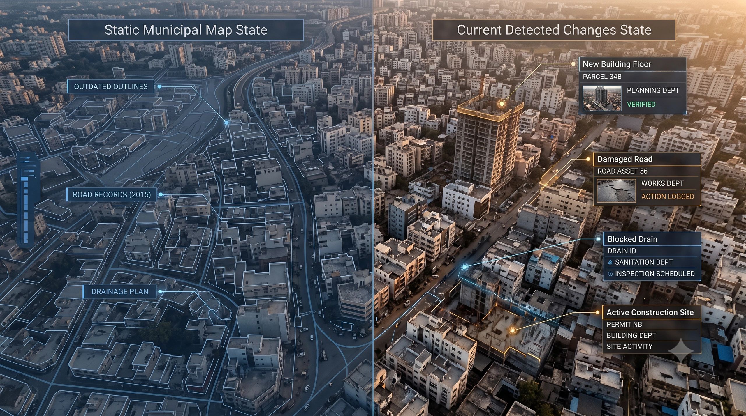
Most cities do not have a shortage of maps.
They have cadastral maps, utility maps, road inventories, development plans, property databases and satellite imagery. Some also have drone surveys, 3D city models and departmental GIS portals.
Yet the official record often falls behind the city it is meant to represent.
A building gains another floor. A drain becomes obstructed. A road deteriorates. A utility line is relocated. A vacant parcel becomes a construction site. A public project is recorded as complete before the physical work matches the claim.
The problem is no longer simply how to map these changes.
The real challenge is how to detect, verify, approve and convert them into accountable municipal action.
That is why the next phase of municipal GIS will not be defined by better-looking maps. It will be defined by governed reality updates.
Physical reality changes faster than official records
Municipal databases are usually created through periodic surveys, departmental submissions and project-based data collection.
These methods remain necessary, but they have a structural weakness: the city keeps changing between update cycles.
When records become outdated, the impact spreads well beyond the GIS department.
An unrecorded building extension can affect property assessment, planning compliance and infrastructure demand. An obstructed stormwater channel can increase flood risk. An outdated road-condition record can distort maintenance priorities. A relocated utility can create safety risks during excavation.
In each case, the spatial error becomes an operational and financial problem.
A technically accurate map created three years ago may be less useful than a modestly detailed map supported by a reliable monthly update process.
Freshness, therefore, should be treated as a core measure of municipal data quality not as an occasional maintenance task.
Detection is becoming easier
Drones, Earth observation, street-level imagery, mobile mapping, IoT sensors and GeoAI are making it easier to observe urban change.
A drone survey can identify new construction or road deterioration. Satellite imagery can reveal land-use change, vegetation loss, waterlogging or urban expansion. Computer vision can compare current imagery with an earlier baseline and flag possible changes.
These capabilities can dramatically reduce the area that municipal teams must inspect manually.
But identifying a change is only the first step.
A system may detect what appears to be a new rooftop structure. That does not immediately establish whether the structure is unauthorized, whether it belongs to the mapped parcel or whether the underlying imagery is sufficiently current and accurate.
Likewise, an algorithm may identify a blocked drain. The result still needs to reach the responsible department, receive appropriate verification and generate a maintenance action.
Detection without institutional closure creates another layer of alerts not better governance.
A city does not update itself
A governed municipal update should connect seven elements:
- Change detected
- Affected parcel, asset or location identified
- Confidence, date and supporting evidence recorded
- Responsible department assigned
- Field or administrative verification completed
- Authorized official record updated
- Tax, permit, repair or enforcement workflow initiated
Each step matters.
Without a persistent parcel or asset identity, the change cannot be linked reliably to the municipal record.
Without evidence and confidence, staff cannot judge whether the finding requires action or further inspection.
Without departmental ownership, the alert can remain unresolved.
Without approval controls, automated updates could weaken the integrity of the authoritative database.
Without an action workflow, the municipality may know that reality has changed but still fail to respond.
The map is therefore not the endpoint. It is the interface through which evidence enters a governed decision process.
The authoritative record must remain protected
GeoAI can accelerate comparison, classification and prioritization. It should not silently rewrite official municipal records.
A well-designed system separates three information states:
- Observed reality: What sensors, imagery or field teams currently indicate.
- Proposed update: A machine-generated or staff-generated change awaiting review.
- Authoritative record: The information formally accepted by the municipality.
This separation protects both speed and accountability.
GeoAI can flag hundreds of possible building changes, rank them by confidence and connect them to parcels. Municipal officers can then review high-priority cases, request field verification and approve valid updates.
The system should preserve who detected the change, which evidence was used, who reviewed it, what decision was made and when the official record changed.
This history becomes essential when an update affects taxation, permits, enforcement, compensation or public expenditure.
Start with one measurable municipal outcome
A citywide transformation programme may sound attractive, but the stronger entry point is a focused operational problem.
Examples include:
- identifying unassessed or modified buildings;
- finding recurring stormwater obstructions;
- detecting illegal construction or encroachment;
- monitoring road-condition changes;
- verifying the completion of public works;
- tracking changes to water or utility assets.
Each use case should begin with a baseline and an operational measure.
For property assessment, the measure might be the number of verified buildings added to the tax workflow. For stormwater management, it could be the time between detecting an obstruction and resolving it. For public works, it could be the percentage of completion claims verified through current field evidence.
This is where municipal GIS moves from data production to measurable service improvement.
Governance must extend across departments
Municipal reality is rarely owned by one department.
A physical change may affect planning, revenue, engineering, utilities, disaster management and public works at the same time. If every department maintains a separate version, the city develops multiple competing realities.
The solution is not necessarily one large application replacing every departmental system.
It is a common spatial identity and update process that allows systems to exchange trusted changes while preserving departmental authority.
This requires agreed asset identifiers, update permissions, evidence standards, review timelines and escalation rules. It also requires clear treatment of uncertain findings.
A low-confidence change may require another image. A medium-confidence result may be sent for field inspection. A high-confidence finding can enter an expedited review queue. Confidence becomes valuable only when it changes the next action.
The commercial model must also change
Traditional municipal mapping projects are often priced around survey area, number of features or delivery of a database.
Those outputs remain important, but the lasting value sits in keeping the database aligned with reality.
This creates room for a recurring Municipal Reality Update Service combining scheduled capture, automated change detection, asset linkage, verification workflows and departmental dashboards.
Survey companies can contribute field capture. Earth-observation providers can supply regional monitoring. Municipal consultants can support process redesign. GIS and spatial-operating platforms can maintain identity, evidence, review history and integration with departmental systems.
The opportunity is not to replace existing enterprise GIS investments. It is to close the workflow between an observed spatial condition and its verified resolution.
Cities do not need another map that becomes outdated after delivery.
They need an accountable system for deciding what has changed, whether the evidence is sufficient, who must respond and when the official record should be updated.
The next generation of urban GIS will be measured by how reliably it keeps the official record aligned with physical reality.