
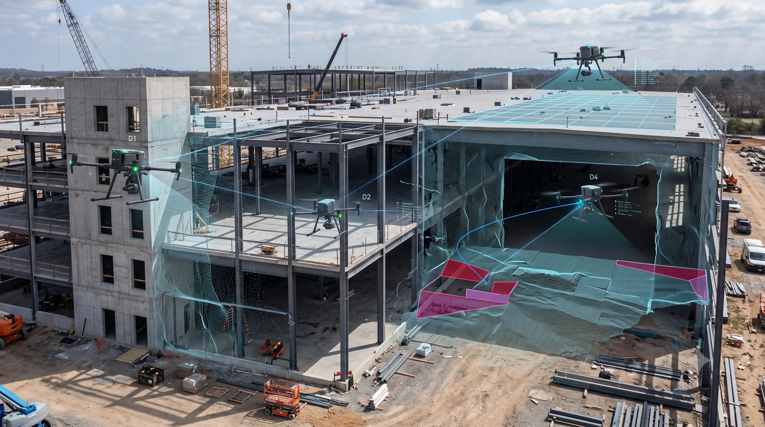
Most UAV mapping operations still follow a familiar model.
One drone flies a predefined route. It captures images or point clouds. The data is processed after the mission. Another flight is planned if something was missed.
This model works, but it is largely sequential.
The speed of the operation depends on how much territory a single UAV can cover, how long its battery lasts and how quickly the collected data can be processed.
Now imagine a different operating model.
Instead of one UAV completing the entire mission, several autonomous UAVs work together. Each drone maps a different part of the environment, exchanges spatial information with the others and adjusts its route based on what the swarm has already discovered.
The result is not five separate maps.
It is one continuously evolving, shared representation of reality.
This is the promise of Multi-Agent Collaborative SLAM, commonly called C-SLAM.
Moving Beyond Single-Agent SLAM
SLAM, Simultaneous Localization and Mapping, allows an autonomous system to estimate its own position while building a map of an unfamiliar environment.
It is already widely used in robotics, autonomous vehicles, mobile mapping and indoor navigation.
Traditional SLAM, however, is generally designed around one agent.
A single UAV observes its surroundings, calculates its position and updates its local map. The entire mission depends on that UAV’s sensors, computing capacity, battery and flight path.
Collaborative SLAM extends this process across multiple autonomous agents.
Each UAV develops its own local understanding of the environment while also contributing to a shared map. The agents exchange selected observations, recognize overlapping areas and coordinate their movements.
In practical terms, the swarm begins to behave less like a collection of individual drones and more like a distributed spatial intelligence system.
How the Collaborative Model Works
Consider a swarm mapping a large industrial facility.
Drone A enters a corridor and detects an obstruction.
In a conventional mission, that information may remain with Drone A until the data is downloaded and reviewed.
In a collaborative mission, Drone A immediately shares the obstacle location and surrounding geometry with the rest of the swarm.
Drone B avoids duplicating the same route.
Drone C redirects itself towards an unmapped area.
Drone D may take over part of the mission if another UAV experiences a low battery or communication problem.
The mission plan is no longer completely fixed before take-off. It evolves in response to the conditions discovered in the field.
Three capabilities make this possible.
Distributed Edge Intelligence
A collaborative swarm cannot depend entirely on a distant cloud platform.
Communication may be limited, delayed or unavailable, particularly inside buildings, forests, mines or disaster zones.
Each UAV therefore requires onboard processing.
It must interpret sensor data, estimate its own movement, identify important features and decide what information should be shared.
Instead of transmitting every image or every point in a point cloud, the UAV can exchange selected changes, landmarks, poses or geometric features.
This reduces bandwidth requirements and enables faster coordination.
Relative Positioning
GNSS is not always available or reliable.
Indoor facilities, underground environments, dense urban areas, forests and damaged infrastructure can all create positioning challenges.
Collaborative systems can reduce this dependency by using relative observations.
The UAVs may detect one another directly or identify common features in the environment. These shared references help the swarm maintain a consistent spatial relationship even when absolute positioning is weak.
The objective is not merely to know where each drone believes it is.
The objective is to ensure that all agents are operating within the same spatial frame.
Global Map Optimization
Each UAV initially creates a local map.
Those maps will contain small differences because of sensor noise, drift and changing viewpoints.
When two UAVs observe the same wall, corridor, machine or structural element, the system can identify the overlap. This is often referred to as loop closure or inter-agent place recognition.
The overlapping geometry allows the system to align the local maps, correct accumulated drift and create a more consistent shared model.
This optimization is what turns several independent data-capture missions into one collaborative mapping operation.
Why This Matters for Reality Capture
The main benefit is not simply that more drones can cover more area.
The deeper value is that reality capture becomes parallel, adaptive and resilient.
Today, survey planning often assumes that the environment will behave as expected. Flight paths, control points and capture sequences are defined in advance.
But real sites are rarely static.
Construction equipment moves. Access routes become blocked. Weather conditions change. Batteries fail. Communication links drop. Areas that appeared accessible during planning may not be accessible during execution.
A collaborative swarm can respond during the mission rather than after it.
This could significantly change how organizations approach large-area mapping, indoor capture, emergency response and infrastructure inspection.
Where C-SLAM Could Create Immediate Value
Agriculture and Forestry
Large farms and forest areas require repeated coverage across substantial terrain.
A coordinated fleet of smaller UAVs could divide the area, capture different zones simultaneously and share information about completed or inaccessible sections.
This could support crop monitoring, canopy analysis, plantation inventory, terrain assessment and post-event damage mapping.
The value would come from reduced mission time, greater operational redundancy and more frequent data collection.
BIM-to-Field and Construction Monitoring
Construction sites are complex three-dimensional environments.
External façades, internal rooms, vertical shafts, structural elements and temporary works may all need to be captured.
A collaborative system could assign separate areas to different UAVs while maintaining one shared site map.
One UAV could inspect the external envelope while others capture interior spaces. Their observations could then be aligned into a unified as-built representation.
This creates a potential pathway towards faster progress monitoring and more frequent updates to BIM and digital-twin environments.
Disaster Response
Disaster zones are unpredictable and dangerous.
Human teams may not know which routes remain accessible, where debris has accumulated or which parts of a structure are unstable.
A UAV swarm could divide the search area and update the shared map as conditions are discovered.
If one UAV fails, the remaining agents could redistribute the incomplete territory.
In this context, redundancy is not only an efficiency feature. It can become a mission-continuity capability.
Industrial Inspection
Large warehouses, processing plants, mines and utility facilities often contain areas where GNSS is unavailable and human access is difficult.
Collaborative UAVs could inspect separate zones while sharing obstacles, structural references and mapped areas.
The resulting spatial layer could support maintenance planning, asset condition assessment, safety reviews and operational digital twins.
The Strategic Opportunity: Swarm-as-a-Service
The business opportunity is larger than selling more drones.
The real offering is coordinated reality capture.
A Swarm-as-a-Service model could combine UAVs, onboard AI, communication networks, mission-planning software, spatial processing and digital-twin integration into one managed service.
Clients would not necessarily need to understand the underlying robotics architecture.
They would purchase outcomes:
Faster site capture.
Greater coverage.
Reduced field exposure.
Improved redundancy.
More frequent updates.
Better integration with operational systems.
This could move UAV services away from isolated survey assignments and towards continuous spatial intelligence.
However, the value will depend on how effectively the captured data enters the client’s decision workflow.
A shared 3D map is useful.
A shared 3D map connected to BIM, GIS, maintenance records, sensor data and operational decisions is far more valuable.
The Challenges Should Not Be Underestimated
Collaborative SLAM is not simply a matter of flying several drones at once.
The swarm must manage communication delays, sensor differences, map conflicts, battery constraints, collision avoidance and cybersecurity risks.
Inter-agent observations must be validated.
Incorrect map matches can distort the shared model.
The system must also indicate confidence. Operators need to know which areas are well mapped, which sections contain uncertainty and where additional evidence is required.
Regulation will be another major consideration.
Multi-UAV operations, beyond-visual-line-of-sight missions and autonomous decision-making may require specific approvals depending on the country and operating environment.
For enterprise deployment, governance will matter as much as autonomy.
Who authorizes the swarm to change its mission?
What happens when agents disagree?
Which map becomes the accepted version?
How is the spatial evidence audited?
These questions will determine whether C-SLAM remains a research capability or becomes a trusted operational service.
The Bigger Shift
Collaborative SLAM represents an important change in how we think about field data acquisition.
The future may not be defined by one highly capable drone performing every task.
It may be defined by several smaller, specialized agents coordinating around a shared spatial objective.
This mirrors a broader shift taking place across digital twins, robotics and AI.
Intelligence is becoming distributed.
Systems are becoming composable.
Operations are becoming collaborative.
Reality capture is moving from a linear process, fly, collect, process and review, towards a continuous loop of sensing, sharing, coordinating and updating.
The competitive advantage will not come from owning the largest UAV fleet.
It will come from orchestrating multiple agents, maintaining a trusted shared map and turning that evolving spatial evidence into decisions.
That is when a drone swarm stops being a collection of flying sensors.
It becomes a distributed spatial intelligence platform.
Do you see collaborative UAV swarms becoming commercially viable first in construction, agriculture, industrial inspection or disaster response?