
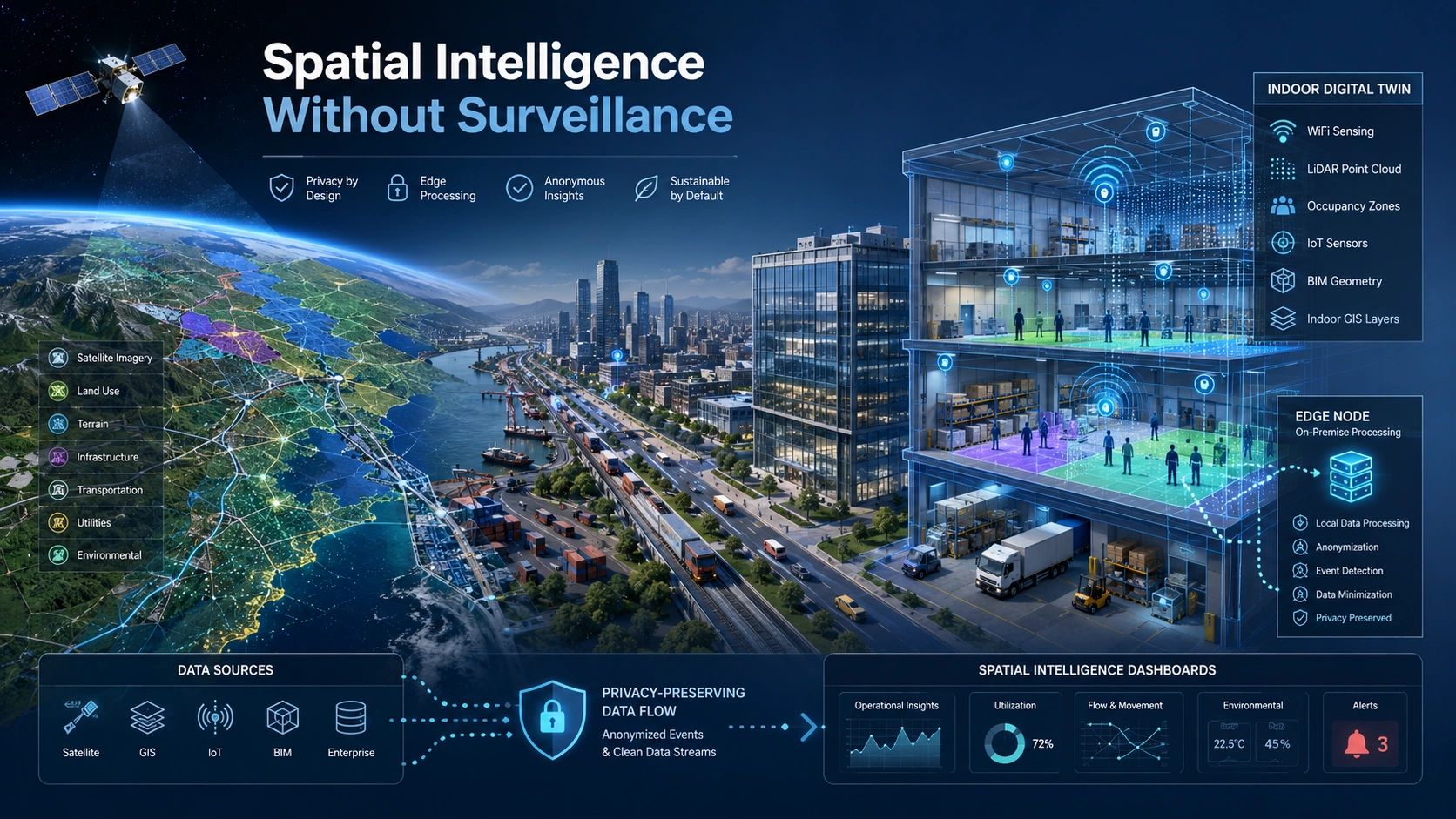
Spatial intelligence has traditionally been built from the outside in.
Satellites observe regions. UAVs inspect sites. Mobile mapping systems capture roads. LiDAR records buildings and infrastructure. These technologies help us understand where assets are located, how landscapes are changing and what risks may be emerging.
But the next stage of spatial intelligence is moving indoors.
Warehouses, hospitals, factories, campuses, transport terminals and commercial buildings increasingly need real-time awareness of people, equipment, environmental conditions and operational activity.
That creates a difficult question:
How do we make indoor digital twins intelligent without turning them into surveillance systems?
This is not only a technology issue. It is a trust, governance and design issue.
Earth observation is moving from detection to reasoning
For many years, Earth-observation analytics focused mainly on detection and classification.
Is this area agricultural land?
Has a building appeared?
Where is flooding occurring?
Which road surface may be damaged?
These are valuable questions. But operational decisions usually require more than identifying objects.
Decision-makers need to understand relationships:
- Is the detected change unusual for this season?
- Is the road anomaly positioned where it creates a safety risk?
- Is agricultural stress caused by moisture, crop stage or local infrastructure?
- Does the observed pattern indicate an isolated event or a wider operational problem?
Recent research directions such as TerraLogic point towards hierarchical reasoning over Earth-observation imagery. Other developments are applying spatial logic to road anomalies and improving remote-sensing models so they can adapt across sensors, seasons and geographies.
The shift is important.
GeoAI is moving from asking:
“What is visible?”
towards asking:
“What does the spatial evidence mean in context?”
That same shift is now beginning inside buildings.
Indoor digital twins need more than 3D models
An indoor digital twin is often introduced as a detailed representation of a building or facility.
The model may include BIM geometry, equipment information, indoor maps, point clouds and live IoT feeds.
But a 3D model does not automatically understand operations.
A warehouse twin may show the position of storage zones without knowing whether an aisle is blocked.
A hospital twin may display room occupancy without understanding movement pressure around emergency areas.
A factory twin may map machines and workers without identifying unsafe interaction patterns.
To become operationally useful, indoor twins must reason about space, movement, proximity, activity and changing conditions.
That normally requires a combination of sensing systems:
- Cameras for visual interpretation
- LiDAR for geometry and movement
- UWB, BLE or RFID for positioning
- Environmental sensors for temperature, air quality and occupancy
- WiFi signals for non-camera human-presence and movement sensing
- BIM and indoor GIS for spatial and asset context
The challenge is that the richer the sensing environment becomes, the greater the privacy risk.
Intelligence and surveillance are not the same thing
Many indoor systems collect more information than the decision actually requires.
For example, a facility manager may need to know that a restricted safety zone has been entered. The system may not need to identify the individual’s face.
A warehouse operator may need to know that two people are carrying an object incorrectly. The system may not need to store identifiable video.
A healthcare facility may need to detect that a person has fallen. It may not need to continuously record private indoor activity.
This distinction is critical.
Operational intelligence asks for the minimum evidence required to support a decision. Surveillance collects extensive information in case it becomes useful later.
Privacy-preserving spatial intelligence should therefore begin with the decision, not with the sensor.
Before selecting a camera, LiDAR system or tracking platform, the project team should ask:
- What decision must the system support?
- What spatial evidence is actually required?
- Does the system need identity, or only presence and movement?
- Can the analysis happen at the edge?
- What data must be retained?
- Who can access the raw evidence?
- Can the twin operate using anonymized or aggregated information?
These questions should be addressed before the technology architecture is finalized.
WiFi sensing changes the indoor intelligence discussion
One emerging option is WiFi Channel State Information, or WiFi-CSI.
WiFi signals change when people move through an indoor environment. AI models can analyze these changes to estimate movement, activity and even aspects of human pose without relying on conventional video.
Recent work such as WiFi-JEPA explores self-supervised WiFi-based 3D human-pose estimation. The research is still developing, but the direction is relevant to smart buildings, warehouses, elderly care, safety monitoring and privacy-sensitive facilities.
WiFi sensing does not remove every privacy concern. Movement patterns can still become sensitive information, especially when linked to identity or retained over time.
But it changes the design options.
Instead of treating cameras as the default sensor for indoor intelligence, organizations can build a layered sensing architecture:
- Use WiFi or occupancy sensors for anonymous presence detection.
- Use UWB or RFID for authorized asset tracking.
- Use LiDAR where precise geometry is needed.
- Activate cameras only for specific events or verification.
- Process sensitive data locally wherever possible.
- Send only alerts, counts or anonymized spatial events to the digital twin.
The objective is not to eliminate sensing. It is to collect only the evidence needed for the operational purpose.
Spatial intelligence must work across scales
For most of my career in geospatial technology, outdoor and indoor systems have been treated as separate domains.
Earth observation covered regions and landscapes.
GIS managed networks, parcels and infrastructure.
BIM represented buildings.
IoT monitored machines and environmental conditions.
Indoor positioning tracked people and equipment.
That separation is becoming less practical.
A logistics operation may need satellite-derived flood intelligence outside the facility, road-condition information along delivery routes, yard-level vehicle awareness and indoor visibility of goods and personnel.
A city may need to connect regional climate risk, street-level infrastructure condition and building-level emergency response.
An agricultural supply chain may need to understand farm conditions, road access, cold-chain facilities and warehouse operations through one spatial decision environment.
Spatial intelligence therefore needs to function across a continuous hierarchy:
region → city → corridor → site → building → room → operational zone
Earth observation provides the wider environmental context.
GIS connects networks, territories and assets.
BIM provides indoor structure and asset semantics.
IoT and edge sensing provide current operational conditions.
AI provides interpretation and reasoning.
The digital twin becomes the environment in which these layers are connected to decisions.
Privacy must be part of the digital-twin architecture
Privacy cannot be added after deployment through a policy document.
It must be designed into the sensing and data architecture.
A privacy-preserving indoor twin should include:
- Purpose-based data collection
- Edge processing for sensitive signals
- Data minimization
- Role-based access
- Limited retention periods
- Clear separation between identity and location events
- Traceable model outputs
- Human review for consequential decisions
- Defined thresholds for action, review or additional evidence
The most advanced digital twin will not necessarily be the one that captures the most data.
It will be the one that produces reliable operational insight while collecting the least intrusive evidence required.
The next competitive edge is trusted reasoning
The recovery of geospatial value will not come from creating more dashboards or adding more sensors.
It will come from building systems that can reason across spatial evidence, explain what that evidence means and operate within clear trust boundaries.
Earth-observation AI is beginning to reason about places, objects and relationships.
Indoor digital twins must do the same but under much stricter privacy expectations.
The opportunity is to connect outside-in intelligence with inside-out operational awareness without compromising the people who occupy those spaces.
That is the next layer of spatial intelligence:
not simply observing everything, but understanding enough to support the right decision.