
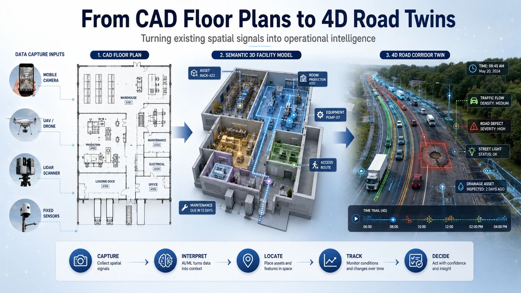
Spatial AI will not scale because every organization creates a perfect 3D model.
It will scale when ordinary spatial signals, CAD drawings, mobile images, mixed cameras, LiDAR, UAV video and sensor feeds, can be converted into reliable operational intelligence.
Many infrastructure owners already possess large volumes of spatial information. But much of it remains trapped inside drawings, disconnected databases, inspection photographs and static models.
The issue is no longer a lack of data.
The issue is turning existing data into something that can answer practical questions:
Where is the asset?
What condition is it in?
What has changed?
What is moving?
What requires attention?
And what action should follow?
Recent developments in depth estimation, floor-plan intelligence, mobile segmentation, UAV cognition and 4D reconstruction suggest that Spatial AI is moving closer to answering these questions in real operational environments.
Legacy floor plans can become operational data
Most buildings, factories, warehouses and infrastructure facilities still depend on CAD drawings created years ago.
These drawings may contain rooms, equipment symbols, access points, utility lines, fire-safety elements and asset references. But the information is usually represented as lines, blocks, text and symbols rather than structured data.
As a result, valuable spatial information remains difficult to search, analyse or connect with live systems.
New multimodal methods for identifying symbols and text in CAD floor plans could change this.
Instead of manually redrawing every floor plan, Spatial AI can begin extracting:
- Room boundaries and functional zones
- Doors, windows and circulation paths
- Equipment and utility symbols
- Asset labels and identifiers
- Emergency and safety infrastructure
- Relationships between spaces and assets
The output is no longer merely an image of a floor plan. It becomes a semantic facility layer that can connect with BIM, GIS, maintenance systems, IoT platforms and digital twins.
This has an immediate business impact.
A warehouse operator could connect equipment locations with maintenance records. A hospital could map critical assets and access routes. A factory could relate production equipment to safety zones and utilities. A facility manager could search for an asset without opening multiple drawings and spreadsheets.
The practical opportunity is not simply “CAD-to-BIM conversion.”
It is CAD-to-operational intelligence.
Digital twin capture is becoming more accessible
High-quality LiDAR and laser scanning will remain important where engineering-grade accuracy is required.
But not every digital twin begins with a full terrestrial scanning programme.
Real-time metric depth estimation from heterogeneous cameras is making it possible to derive useful spatial measurements from ordinary or mixed camera systems. Lightweight LiDAR-camera models are also reducing the computing power required for 3D perception.
This creates a wider range of capture options.
A field team may use a mobile camera for preliminary asset mapping. A vehicle-mounted system may capture road conditions. A UAV may inspect a bridge, transmission corridor or industrial structure. A warehouse may use existing cameras to monitor movement and occupancy.
These systems will not replace survey-grade capture in every situation.
The important change is that organizations can match the capture method to the decision being made.
A structural retrofit requires different accuracy from a maintenance inspection.
A visual condition survey requires different evidence from a cadastral boundary measurement.
A warehouse movement twin requires different update frequency from an architectural as-built model.
The strongest Spatial AI systems will therefore combine multiple levels of spatial truth rather than forcing every use case into one expensive capture method.
Field inspection is moving to the edge
Infrastructure inspection remains one of the clearest near-term applications.
Road agencies, utilities, industrial operators and facility owners already collect large numbers of images. The problem is that these images often require manual review, inconsistent classification and delayed reporting.
Lightweight segmentation models can help identify roads, buildings, crops, equipment and damaged surfaces directly on mobile or edge devices.
Crack segmentation is a good example.
A field application could capture an image, identify the crack region, estimate its extent, record its location and attach the result to the relevant asset.
The inspection then becomes more than a photograph.
It becomes structured evidence containing:
- Asset identity
- Geographic position
- Defect category
- Severity or confidence level
- Inspection timestamp
- Previous condition
- Recommended review or action
This creates a continuous link between field observation and asset management.
However, automated detection should not be presented as unquestionable truth. A responsible workflow should preserve the source image, model confidence, inspection context and human verification status.
The objective is not to remove the engineer.
It is to help the engineer review more assets, detect changes sooner and focus attention where the risk is highest.
Road twins must move beyond static geometry
Many road digital twins still resemble updated 3D maps.
They represent lanes, signs, barriers, bridges and surrounding terrain. This is useful, but roads are not static systems.
Vehicles move.
Lane conditions change.
Construction zones appear.
Water accumulates.
Vegetation grows.
Assets deteriorate.
Traffic behavior varies by time, weather and events.
The next generation of road twins must therefore include time as a core dimension.
Emerging 4D reconstruction methods can represent road scenes as they change, including moving vehicles and dynamic objects. Spatio-temporal reasoning models can also track evidence across multiple frames rather than treating each image as an isolated observation.
This turns the road twin from a visual record into an evolving operational model.
A practical 4D road twin could help answer:
Which defect is getting worse?
Where do vehicles repeatedly deviate from the expected path?
How does congestion develop around a junction?
Did a roadside asset move or become obstructed?
Which safety condition appeared after the previous survey?
What changed between two corridor captures?
For road authorities, this means moving from periodic mapping toward continuous corridor intelligence.
For autonomous mobility teams, it provides richer environments for validation.
For maintenance contractors, it creates traceable evidence of condition, intervention and change.
Spatial AI needs a practical architecture
Across these examples, a common workflow is emerging:
Capture → Interpret → Locate → Track → Decide
Capture may begin with a CAD file, mobile camera, UAV, LiDAR system or fixed sensor.
Interpretation identifies spaces, assets, objects and defects.
Location connects every observation to a building, road corridor, floor, room or asset.
Tracking establishes what changed over time.
Decision logic determines whether the next step is action, human review or additional evidence collection.
The technology becomes valuable only when this complete chain works.
Over 27 years in the geospatial sector, I have seen organizations invest heavily in data creation while underinvesting in the final link to operations.
Accurate maps can remain unused.
Detailed BIM models can become outdated.
Inspection images can disappear into folders.
Dashboards can display conditions without changing decisions.
Spatial AI offers an opportunity to close this gap but only when it is designed around the decision first.
The practical future of Spatial AI will not be defined by one model, sensor or platform.
It will be defined by how effectively organizations turn the spatial information they already possess into evidence they can trust and actions they can execute.