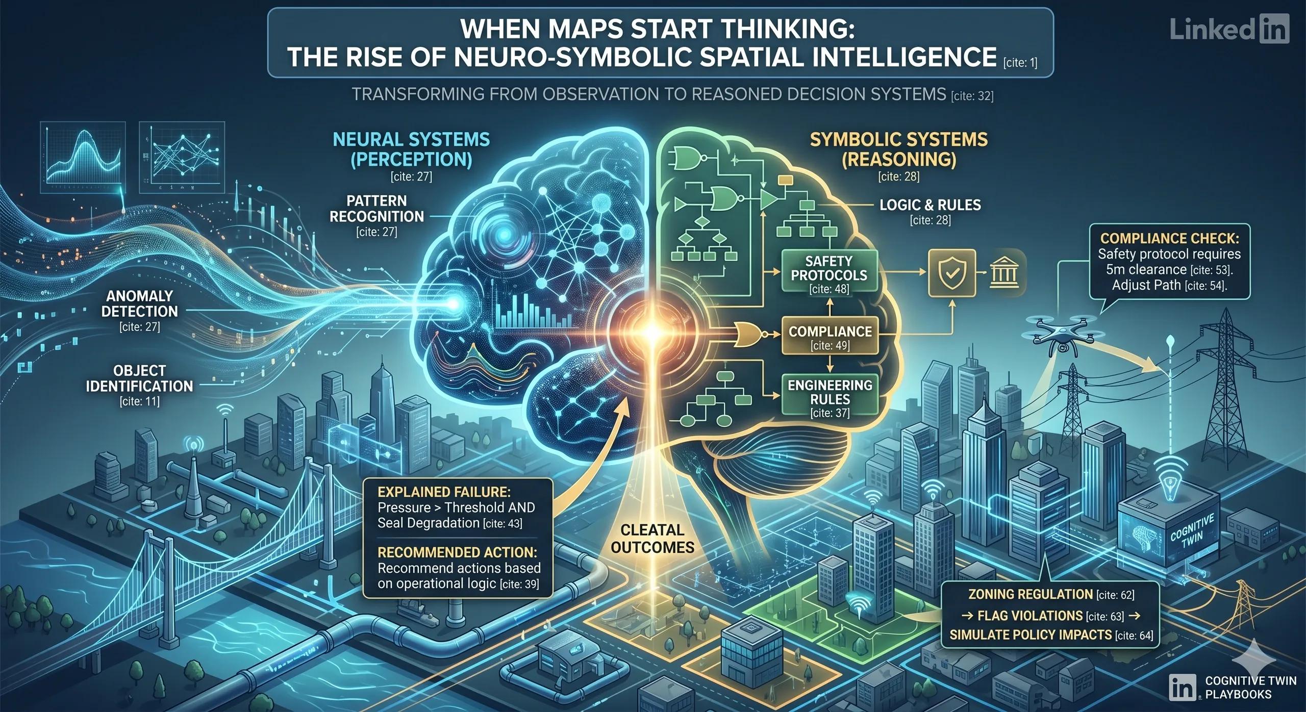
Opening Reflection
What if our maps didn’t just show reality but understood it?
For decades, geospatial systems have evolved from static representations to dynamic, real-time digital environments. We moved from paper maps to GIS, from GIS to Digital Twins. Yet, despite all this progress, one gap remains: our systems can see patterns, but they struggle to understand meaning.
That gap is now starting to close.
Context: A Shift in How Machines Understand Space
Artificial Intelligence has already reshaped how we process spatial data. Neural networks can identify roads, buildings, cracks in infrastructure, or anomalies in satellite imagery with impressive accuracy. But when it comes to reasoning, understanding why something matters or what should happen next , they fall short.
This limitation becomes critical in real-world environments:
A system can detect a damaged pipeline but cannot explain the cause.
A drone can avoid obstacles but may not follow safety protocols logically.
A digital twin can show anomalies but cannot justify decisions in operational terms.
This is where a new paradigm is emerging, one that combines perception with reasoning.
The Deeper Question: Can Intelligence Exist Without Understanding?
We are entering a phase where machines can act like they understand, but do not truly reason about consequences. They simulate intelligence but lack structured logic.
This raises a deeper question:
Are we building systems that observe the world or systems that can interpret it meaningfully ?
Because in infrastructure, utilities, urban planning, and environmental management, decisions are not just data-driven, they are rule-driven.
And rules require reasoning.
Spatial Intelligence Perspective: The Emergence of Neuro-Symbolic AI
Neuro-Symbolic AI brings together two fundamentally different approaches to intelligence:
Neural Systems (Perception): These excel at pattern recognition. They identify objects, detect anomalies, and process vast geospatial datasets.
Symbolic Systems (Reasoning): These rely on logic, rules, and structured relationships. They understand cause-effect, compliance, and constraints.
When combined, they create a system that not only sees spatial data—but understands the rules governing it.
This shift is subtle but powerful.
It transforms geospatial platforms from descriptive systems into cognitive systems .
Real-World Implication: From Observation to Decision Systems
Let’s break this down in practical terms across key domains:
Digital Twins: From Visualization to Explanation
Today’s digital twins show real-time data, temperature, pressure, movement. But they often stop at alerts.
With neuro-symbolic intelligence:
The system can connect sensor data with engineering rules.
It can explain failures, not just detect them.
It can recommend actions based on predefined operational logic.
Instead of:
“Anomaly detected.”
You get:
“Failure likely due to pressure exceeding threshold while vibration pattern indicates seal degradation.”
This is not just monitoring. It’s reasoning.
Autonomous UAVs: From Navigation to Compliance
Drones today rely heavily on perception, detecting obstacles and navigating around them.
But real-world operations require more:
Safety protocols
Regulatory compliance
Context-aware decision-making
A neuro-symbolic UAV can reason:
“This is a power line.”
“Safety protocol requires 5-meter clearance.”
“Adjust path accordingly, even if visual input is uncertain.”
This bridges the gap between sensing and decision-making.
Smart Cities: From Data Layers to Policy Intelligence
Urban systems are governed by rules, zoning laws, environmental constraints, infrastructure guidelines.
Traditional AI struggles here because:
Rules are complex and layered
Data is incomplete or noisy
Neuro-symbolic systems can:
Apply zoning regulations directly on geospatial datasets
Flag violations automatically
Simulate policy impacts before implementation
This brings governance into the data layer itself.
Infrastructure & Environmental Monitoring: From Alerts to Accountability
In high-stakes environments, decisions must be explainable.
A system that flags a risk must also answer:
Why was this flagged?
Which rules were violated?
What evidence supports this conclusion?
Neuro-symbolic AI enables this transparency:
Logic rules are human-readable
Decisions can be traced back to conditions
This directly addresses the “black box” problem in AI.
Insight: The Shift Toward Cognitive Twins
What we are witnessing is not just an upgrade in AI, it is a shift in how we define digital systems.
We are moving from:
Digital Twins → Cognitive Twins
A digital twin shows:
What is happening
A cognitive twin explains:
Why it is happening
What should happen next
This distinction matters.
Because real value in geospatial systems is not in visualization but in decision support.
Benefits & Value Creation
Adopting neuro-symbolic spatial intelligence can unlock:
Better Decision-Making:
Systems provide context, not just data
Explainability:
Clear reasoning behind every output
Regulatory Alignment:
Built-in compliance with rules and policies
Operational Efficiency:
Reduced manual interpretation and faster response
Trust in AI Systems:
Transparency increases adoption in critical sectors
Use Case Example: Urban Flood Risk Management
Imagine a city digital twin monitoring flood risk:
Neural models detect rising water levels and rainfall patterns
Symbolic rules incorporate zoning laws, drainage capacity, and risk thresholds
The system can:
Identify high-risk zones
Explain why those zones are vulnerable
Recommend evacuation or mitigation strategies
This is not just prediction, it is actionable intelligence.
Closing Reflection
We often talk about making infrastructure “smart.” But intelligence is not just about sensing, it is about understanding.
As geospatial systems evolve, the question is no longer:
“How much data can we process?”
The real question is:
“Can our systems reason about the world they are modeling?”
Because the future of spatial intelligence will not be defined by better maps.
It will be defined by systems that can think through space.