For years, digital transformation has been built around one quiet assumption:
To make systems intelligent, we must first collect all the data in one place.
Images from drones.
Sensor streams from factories.
Point clouds from infrastructure sites.
Satellite data from landscapes.
BIM models from buildings.
IoT data from machines.
The usual approach has been simple: gather, upload, centralize, process, and train.
But as geospatial systems become larger, more sensitive, and more real-time, this model is starting to show its limits.
Because the future of spatial intelligence may not depend on moving more data.
It may depend on moving intelligence closer to where the data already lives.
This is where Federated Learning in Geospatial AI, or Geo-FL, becomes important.
At its core, federated learning changes a basic question.
Instead of asking, “How do we bring all data to the model?” It asks, “How do we bring the model to the data?”
That shift may sound technical, but its implications are much larger.
It changes how we think about privacy.
It changes how we think about bandwidth.
It changes how we think about national data sovereignty.
And most importantly, it changes how we scale intelligence across physical systems.
The Context: Why Centralized AI Is Becoming Difficult
Geospatial AI depends on massive datasets.
A drone survey of a highway corridor can produce huge volumes of imagery and 3D data.
A smart city platform may collect signals from traffic cameras, weather stations, utility networks, and field teams.
An agricultural monitoring program may need to analyze crop stress across thousands of farms.
A digital twin of an industrial facility may continuously receive operational data from equipment, people, spaces, and sensors.
In theory, all this data can be uploaded to the cloud.
In practice, it is not always that simple.
Remote sites may not have strong connectivity.
Industrial clients may not allow sensitive operational data to leave their premises.
Public infrastructure projects may involve strict data localization requirements.
Farm-level datasets may raise questions around ownership, consent, and misuse.
Large imagery and point cloud files can become expensive to transmit and store.
So the challenge is not only technical.
It is architectural.
We cannot keep designing future geospatial AI systems as if every project, every sensor, every drone, every building, and every region will comfortably send raw data into one central repository.
That model worked when intelligence was limited.
It becomes harder when intelligence must operate everywhere.
The Deeper Question
GeoThinking always brings us back to the deeper layer behind the technology.
The question is not only:
Can AI detect crop disease, pipeline leakage, structural cracks, or land-use change?
The deeper question is:
Can AI learn from distributed physical environments without violating the trust, privacy, and sovereignty of those environments?
This is important because geospatial data is not ordinary data.
It is tied to land.
It is tied to infrastructure.
It is tied to homes, farms, factories, roads, utilities, and borders.
It often reveals patterns of movement, ownership, risk, vulnerability, and economic activity.
When we centralize geospatial data, we are not just moving files.
We are moving context.
And context has power.
That is why Federated Learning is more than an AI technique. It is a governance idea.
It allows intelligence to grow across many locations without forcing all raw data into a single central system.
The Spatial Intelligence Perspective
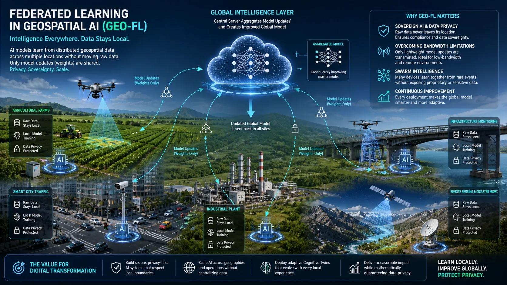
Let us imagine a fleet of drones monitoring agricultural fields across different regions.
In a conventional AI workflow, each drone captures imagery and uploads it to a central cloud platform. The central system trains a model to identify crop disease, pest stress, waterlogging, or nutrient deficiency.
But in a federated approach, the drone or local edge system trains the model on-site.
The raw imagery stays local.
Only the learning from that data, represented as mathematical model updates, is sent back to a central system.
The central system then combines learnings from many locations and creates an improved global model. That improved model is pushed back to all participating drones or local systems.
The same idea can apply to many geospatial use cases.
A pipeline operator can improve leak detection models across multiple regions without exposing raw inspection imagery from each asset.
A city can improve traffic intelligence across different junctions without centralizing every video stream.
An industrial group can improve safety analytics across many plants without sharing sensitive facility data.
A utilities company can train fault detection models across substations while keeping operational data within local boundaries.
A disaster management system can learn from flood patterns across districts while reducing the need to move heavy datasets.
This is the real power of Geo-FL.
Each site learns locally.
The network improves collectively.
The raw data remains where it belongs.
Real-World Implication: From Data Pipelines to Learning Networks
This changes how we design digital twins.
Many digital twins today are still built as data platforms. They collect, visualize, and analyze information from the physical world.
But the next generation of cognitive digital twins will need to learn continuously.
A digital twin of a port should learn from vessel movement, cargo flow, weather, energy use, and equipment behavior.
A digital twin of a highway should learn from traffic, pavement condition, weather stress, safety events, and maintenance history.
A digital twin of a solar field should learn from irradiance, panel performance, vegetation growth, dust accumulation, and thermal variation.
A digital twin of a city should learn from mobility, climate, utilities, public assets, land use, and human behavior.
But these systems cannot always depend on centralized data movement.
They need distributed learning.
That means the intelligence layer must be designed differently.
AI cannot remain only in the cloud.
It must also exist at the edge.
It must work with local data.
It must respect boundaries.
It must learn from many places without forcing those places to surrender control.
This is especially relevant for India and other large, diverse geographies.
A model trained only on one region may fail in another. Soil conditions change. Building materials change. Road usage patterns change. Crop types change. Informal urban growth changes. Weather behavior changes.
Federated geospatial learning can help create models that are locally aware and nationally scalable.
That is a major shift.
It moves us away from one-size-fits-all AI.
It moves us toward spatially adaptive AI.
The Insight: Intelligence Must Become Distributed
The future of geospatial AI will not be defined only by bigger models.
It will be defined by better architectures.
A centralized model may be powerful, but it can still be disconnected from the physical diversity of the real world.
A distributed learning system is different.
It accepts that intelligence must emerge from many places at once.
From the farm.
From the drone.
From the factory.
From the road.
From the sensor.
From the edge device.
From the local digital twin.
This is where federated learning becomes a bridge between AI, geospatial systems, edge computing, digital twins, and data governance.
It allows spatial intelligence to scale without becoming extractive.
That is an important philosophical point.
The goal should not be to pull every piece of reality into a central machine.
The goal should be to let many parts of reality contribute to collective intelligence while retaining local control.
That is a more balanced model of digital transformation.
Closing Reflection
For a long time, we believed that intelligence required centralization.
Centralized databases.
Centralized platforms.
Centralized control rooms.
Centralized AI models.
But the physical world is not centralized.
It is distributed.
Infrastructure is distributed.
Risk is distributed.
Knowledge is distributed.
Operations are distributed.
Human experience is distributed.
So maybe the next phase of Geospatial AI must follow the same logic.
Not one intelligence watching everything from above.
But many local intelligences learning together.
Federated Learning in Geospatial AI points toward that future.
A future where digital twins become smarter without demanding unrestricted access to all raw data.
A future where drones, sensors, assets, and infrastructure systems become part of a shared learning network.
A future where privacy and intelligence are not treated as opposing goals.
A future where spatial AI grows closer to the ground, closer to operations, and closer to the realities it is meant to understand.
The next question for digital transformation leaders is not only how much data they can collect.
It is how intelligently they can learn from data without unnecessarily moving it.
Because the future of geospatial intelligence may not be centralized.
It may be federated.
And that may be the architecture that finally allows AI to scale across the physical world responsibly.
What do you think: will the future of Geospatial AI be built around centralized platforms, or distributed learning networks?