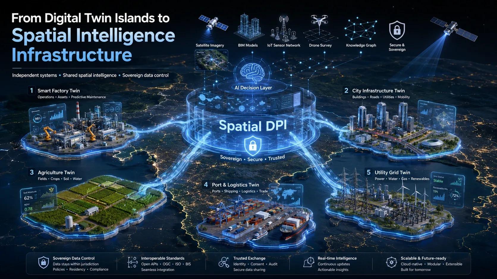
Most digital twins today are still built like private islands.
A factory builds its own operational twin.
A city builds its own mobility dashboard.
A utility builds its own asset monitoring platform.
A port builds its own logistics control system.
An agriculture enterprise builds its own crop intelligence model.
Each system may be technically advanced.
Each may generate insights.
Each may improve a specific workflow.
But the larger question remains:
What happens when these systems need to talk to each other?
Because the real world does not operate in isolated systems.
A flood does not stop at a municipal boundary.
A supply chain does not stop at a factory gate.
A carbon footprint does not stop at a farm boundary.
A construction project does not stop at a BIM model.
A logistics route does not stop at a port terminal.
The physical world is interconnected.
But our digital systems are still fragmented.
That is where the next big shift begins.
Not just from maps to models.
Not just from models to twins.
But from isolated digital twins to Spatial Digital Public Infrastructure .
Context: From Digital Twins to Spatial DPI
India has already shown the world the power of Digital Public Infrastructure.
UPI changed the way payments move.
Aadhaar changed the way identity is verified.
DigiLocker changed how documents are accessed and trusted.
These systems did not succeed only because they were digital.
They succeeded because they created trusted, interoperable rails.
They allowed many public and private actors to participate without everyone having to build everything from scratch.
Now imagine a similar architecture for spatial intelligence.
A national or sectoral spatial infrastructure where geospatial data, BIM models, IoT streams, satellite observations, drone surveys, environmental records, land parcels, logistics routes, and infrastructure assets can interact securely.
Not by dumping all data into one central database.
But by creating trusted data spaces where different actors can share what is necessary, when necessary, with control, consent, and governance.
This is the idea behind Spatial Digital Public Infrastructure .
It is not simply a GIS platform.
It is not only a digital twin.
It is not just a data marketplace.
It is a trusted spatial layer for the economy.
The Deeper Question
The question is no longer:
Who owns the data?
That question still matters. But it is incomplete.
The deeper question is:
How can data remain sovereign, yet still become useful across systems?
This is where the idea of Sovereign Data Spaces becomes important.
In many sectors, organizations are reluctant to share data.
And rightly so.
A factory may not want to expose production data.
A farmer may not want to lose control over land and crop data.
A government may not want sensitive infrastructure data to move outside its jurisdiction.
A logistics company may not want competitors to access route intelligence.
A utility may not want operational vulnerabilities exposed.
But at the same time, modern compliance, resilience, sustainability, and supply chain systems require shared intelligence.
So the challenge is not just technical.
It is structural.
How do we allow systems to learn from each other without forcing everyone to surrender control?
How do we make spatial data interoperable without making it vulnerable?
How do we create shared intelligence without creating centralized dependency?
This is where the future of digital twins begins to change.
Spatial Intelligence Perspective
A Spatial DPI architecture can be understood in three layers.
The first is the physical layer .
This is where ground reality is captured.
Drones, DGPS surveys, LiDAR, satellite imagery, IoT sensors, field mobile apps, SCADA systems, BIM models, and remote sensing platforms all contribute to this layer.
This is the layer of observation.
It tells us what exists, where it exists, and how it is changing.
The second is the semantic layer .
This is where raw spatial data becomes meaningful.
A land parcel is not just a polygon.
A road is not just a line.
A building is not just a 3D object.
A sensor is not just a point on a map.
Each object has relationships, rules, history, ownership, risk, compliance status, and operational meaning.
This is where knowledge graphs, ontologies, GeoSPARQL, BIM-GIS integration, and metadata standards become critical.
The semantic layer allows different systems to understand each other.
A private company’s BIM model can reference the same geographic reality as a government land record.
A satellite-based land cover dataset can connect with a farmer registry.
A logistics route can connect with flood risk zones.
A carbon credit claim can connect with verified vegetation history.
Without semantics, data only overlaps.
With semantics, data begins to reason.
The third is the cognitive layer .
This is where AI enters.
But not as a generic intelligence layer detached from context.
Here, AI is trained and applied within sovereign, governed, domain-specific data spaces.
This matters because infrastructure logic, agricultural intelligence, urban risk models, and environmental compliance systems cannot be treated as simple cloud-based prediction engines.
They affect policy, livelihoods, markets, safety, and national capability.
So the future is not just AI on spatial data.
It is sovereign AI operating on trusted spatial data spaces .
Real-World Implication: Supply Chain Provenance
One of the strongest applications of Spatial DPI is deep-tier supply chain provenance.
Take agriculture, forestry, mining, food exports, or carbon farming.
Global compliance is becoming more spatial.
For example, proving that a product is deforestation-free is no longer a paperwork exercise.
It requires location-level evidence.
Where was the commodity produced?
What was the land cover history?
Was there forest loss after a specific cut-off date?
Which aggregator handled it?
Which warehouse stored it?
Which port moved it?
Which certification body verified it?
A static map is not enough.
A certificate alone is not enough.
A spreadsheet is not enough.
What is needed is a dynamic chain of spatial trust.
The farmer’s field boundary, satellite imagery, IoT soil data, crop records, aggregator movement, warehouse location, logistics route, and export documentation must all connect into a trusted provenance graph.
Each actor contributes verified data without exposing everything.
The buyer receives compliance confidence.
The farmer gains access to premium markets.
The exporter reduces audit risk.
The regulator gains traceability.
The ecosystem gains trust.
This is where Spatial DPI moves from concept to economic infrastructure.
It can support EUDR compliance, carbon MRV, regenerative agriculture, water stewardship, disaster resilience, port intelligence, urban planning, and infrastructure lifecycle management.
The same pattern applies across sectors.
When spatial data becomes interoperable, trusted, and governed, it stops being only a technical asset.
It becomes a market enabler.
GeoThinking Insight
The next generation of digital transformation will not be defined only by who builds the best dashboard.
It will be defined by who builds the most trusted connections between systems.
For years, the geospatial industry has focused on creating better maps, better models, better platforms, and better visualizations.
That will continue.
But the strategic value is now shifting.
The real opportunity is to build the spatial trust layer between organizations, sectors, and jurisdictions.
This is why Spatial DPI is not just a technology conversation.
It is a governance conversation.
It is a sovereignty conversation.
It is an interoperability conversation.
It is a business model conversation.
Digital twins showed us how to mirror assets.
Spatial DPI may show us how to connect economies.
And Sovereign Data Spaces may show us how to do it without forcing everyone into one central system.
This is important because the future will not be built on one mega-platform.
It will be built on many systems that remain independent, but still understand each other.
That is a very different idea of intelligence.
Not centralized intelligence.
But connected intelligence.
Not data extraction.
But governed participation.
Not digital control.
But spatial coordination.
Closing Reflection
When we speak about digital twins, we often imagine a building, a factory, a city, or a utility network.
But perhaps the next step is larger.
A digital twin of a single asset improves operations.
A digital twin of a city improves planning.
But a Spatial DPI can improve how entire ecosystems coordinate.
It can allow infrastructure, agriculture, climate, logistics, utilities, finance, and governance systems to interact through a common spatial trust layer.
That is where the true power of geospatial thinking lies.
Not just in seeing the world more clearly.
But in helping different systems act together without losing their independence.
The future of spatial intelligence may not be about moving all data into one place.
It may be about allowing trusted intelligence to move across many places.
And that may become one of the most important foundations of the next digital economy.