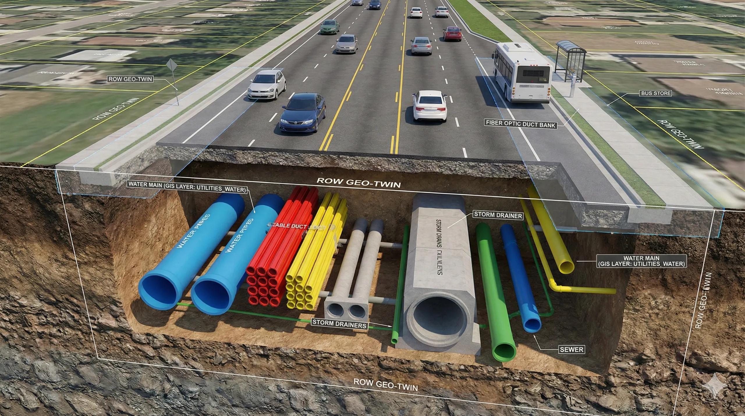
What if the most important part of a city isn’t visible at all?
Beneath every road lies a dense and fragile world, pipes, cables, ducts, conduits, manholes, chambers, joints, valves, and fiber loops, all intertwined like roots beneath a forest floor.
Yet this underground ecosystem is still one of the least-mapped, least-coordinated, and least-digitized layers of urban infrastructure.
Enter Right-of-Way Digital Twins , the convergence of BIM-GIS + utility mapping + 3D subsurface modeling , where the underground is treated as a precise, coordinated, update-ready digital asset system .
This is how cities prevent accidental strikes, reduce downtime, avoid rework, and optimize urban operations.
1️⃣ Why the Underground Matters More Than Ever
Across Indian cities and global metros, underground systems now carry:
water supply
sewer & stormwater
electrical LV/HV
fiber & 5G
district cooling
gas distribution
OFC networks
IoT sensor backbones
Every time a contractor digs a trench without knowing what lies below, the city takes a risk.
Every time two utilities overlap, future maintenance becomes hazardous.
Right-of-Way Twins transform this risk into confidence.
2️⃣ Underground as BIM + GIS: The Best of Both Worlds
Utilities behave like BIM objects , but they live inside spatial contexts governed by GIS.
Combining them gives a unified model where:
BIM provides geometry + attributes (material, diameter, joints, manufacturer)
GIS provides position + topology (depth, orientation, offsets, ROW boundaries)
This results in a multi-dimensional subsurface map that understands:
utility-to-utility clearance
proximity to foundations
encroachments
permitted depths & offsets
duct sharing and trench reuse
clash risk during construction
3️⃣ Data Sources for Right-of-Way Twins
Utilities rarely come from a single dataset. True subsurface twins blend:
A. As-built BIM models
From contractors, EPCs, pipeline designers.
B. Survey-grade GIS
DGPS, total station, and drone photogrammetry for above-ground anchoring.
C. GPR & ERT Scans
Ground Penetrating Radar and Electrical Resistivity Tomography for hidden utilities.
D. CCTV pipe inspections
To extract slope, blockage, structural integrity.
E. LiDAR + 3D scanning
For tunnels, substations, and vaults.
F. Legacy CAD and PDFs
Still common in utilities; needs vectorization and schema mapping.
G. IoT sensors
Real-time monitoring: flow, pressure, temperature, outages.
The twin becomes the integration layer that brings all these fragmented sources together.
4️⃣ How ROW Twins Operate
Right-of-Way Digital Twins perform continuous operations :
A. Clash Detection Before Construction
Detects:
fiber vs stormwater conflicts
gas vs electrical crossing
sewer vs road foundations
illegal borewells
trench depth violations
B. Excavation Planning & Permitting
Authorities can simulate:
dig zones
trench sharing
service diversion plans
shutdown impacts
Contractors see exactly what they are allowed to dig into.
C. Asset Health & Condition Modelling
Combines inspection data with spatial analytics:
corrosion risk → soil type + age + moisture
pipe sagging → CCTV grade + slope models
leakage probability → pressure anomalies + soil infiltration
D. Outage & Maintenance Simulation
During shutdowns:
water pressure redistribution
electricity load balancing
network rerouting
OFC failover paths
traffic impact for trenching
E. Emergency Response
For bursts, explosions, or fiber cuts:
nearest valve
nearest joint
shortest isolation path
alternate routes
expected affected population
All computed instantly from the integrated twin.
5️⃣ India’s Need for ROW Twins (Huge Gap + Huge Opportunity)
Indian cities face recurring challenges:
frequent utility strikes
unplanned trenching
rework during road widening
poor utility documentation
lack of depth metadata
no single authoritative master map
Projects like AMRUT 2.0, BharatNet, Smart Cities Mission, and metro expansions are accelerating the need for:
3D GIS
Subsurface Utility Engineering (SUE)
BIM-in-GIS workflows
Digital twins for road corridors
ROW twins will soon become mandatory for Tier-1 and Tier-2 cities.
6️⃣ GeoAI for Underground Operations
AI-enhanced subsurface modelling unlocks new capabilities:
CNNs classify GPR signatures → pipe vs cable vs void
NLP extracts utility metadata from PDFs & drawings
Vector embeddings match legacy CAD layers to schemas
Graph neural networks model utility topology
Predictive leak models using pressure + soil + age
Anomaly detection for health monitoring
This raises underground intelligence to operational level.
7️⃣ Right-of-Way Digital Twin Architecture (Practical Stack)
A robust ROW twin integrates these layers:
3D Base Mesh → roads, pavements, drainage
Utility Networks → BIM objects in GIS coordinates
Depth Models → trench depth, offsets
Regulatory Geometry → ROW limits, no-dig zones
Hazard Layers → flooding, subsidence
IoT Sensor Layer → pressures/flows/outages
Simulation Layer → clash detection, routing, shutdowns
Interface Layer → dashboards + field apps
This turns the underground into an intelligent, queryable system .
Conclusion
The underground is no longer a hidden world, it is a high-value geospatial asset system .
By fusing BIM + GIS + SUE + IoT + GeoAI, utilities and right-of-way corridors become continuously updating digital twins that guide construction, maintenance, and emergency response.
Right-of-Way Twins are the missing link for modern cities, the connective tissue that brings order to the chaos beneath our feet.