Waterborne diseases, such as cholera, typhoid, and dysentery, remain a persistent threat to public health, especially in developing nations where water sanitation infrastructure is lacking or degraded. These diseases are typically spread through contaminated drinking water and poor hygiene conditions. Traditional surveillance methods often rely on lagging indicators, such as hospital admissions or outbreak reports, which are reactive rather than preventive.
In this context, satellite-based remote sensing presents a powerful, scalable, and non-intrusive means to detect and monitor environmental conditions that facilitate the spread of waterborne diseases. Specifically, technology enables the identification and tracking of key risk factors such as water stagnation, surface water extent, land use changes, contamination potential, and population vulnerability. This article explores the technical principles and applications of using satellite data to monitor waterborne diseases, focusing on how remote sensing supports early warning systems and targeted public health interventions.
Key Risk Factors for Waterborne Disease Spread
Monitoring waterborne diseases with satellite data primarily revolves around observing the environmental precursors that influence pathogen transmission. These include:
Water Stagnation : Stagnant water acts as a breeding ground for pathogens and vectors like mosquitoes, which also contribute to diseases like malaria and dengue, often co-existing with waterborne outbreaks.
Flood Events : Flooding often leads to contamination of drinking water sources and triggers large-scale outbreaks of cholera and other diseases.
Poor Sanitation and Sewage Overflow : Informal settlements and urban slums with open defecation or poor sewage disposal increase contamination risk, often traceable via land use patterns.
Agricultural Runoff : Areas with high levels of nitrogen or phosphorus runoff can lead to eutrophication and algal blooms, further reducing water quality and increasing pathogen proliferation.
Population Density and Migration : High-density zones are more vulnerable to rapid disease transmission once contamination begins.
Remote sensing allows near real-time and historical monitoring of these risk factors at regional, national, and global scales.
Satellite Sensors and Data Relevant for Monitoring
1. Optical and Multispectral Sensors
These sensors capture reflectance in visible and infrared bands, which are useful for:
Detecting Water Bodies : Spectral indices like NDWI (Normalized Difference Water Index) and MNDWI (Modified NDWI) help identify water presence and changes in surface extent.
Monitoring Algal Blooms : Sensors like MODIS (Moderate Resolution Imaging Spectroradiometer) and Sentinel-2 can detect chlorophyll-a concentrations and floating algal mats.
Land Use Mapping : Helps identify informal settlements, waste disposal zones, and encroached wetlands where disease risk is elevated.
2. Thermal Infrared Sensors
Used for assessing water temperature and evaporation levels, which influence bacterial growth. For instance:
Landsat 8 TIRS : Provides thermal data that supports water quality monitoring.
MODIS Aqua/Terra : Useful for observing large water bodies' surface temperature trends.
3. Synthetic Aperture Radar (SAR)
SAR sensors like Sentinel-1 are especially useful for:
Flood Mapping : Capable of penetrating cloud cover to detect flood-affected zones.
Urban Water Logging : SAR data can delineate stagnant water even in densely populated areas, regardless of weather conditions.
4. Gravimetric and Passive Microwave Sensors
These include NASA’s GRACE and SMAP missions:
GRACE : Measures groundwater depletion and seasonal changes, helping assess long-term water scarcity and indirect disease risk.
SMAP : Measures soil moisture, a contributing factor to runoff-related water contamination.
Data Integration and Disease Prediction Models
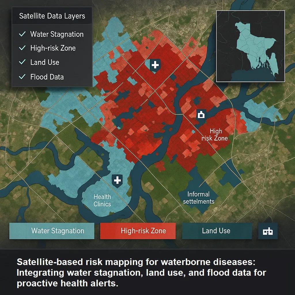
Raw satellite data is transformed into actionable health intelligence using spatial analysis, AI/ML models, and epidemiological overlays. Here's how the pipeline typically functions:
Step 1: Environmental Risk Mapping
Combining water extent indices, flood detection layers, land use classifications, and thermal anomalies into composite maps that highlight high-risk zones.
Step 2: Temporal Analysis
Time-series data of flood events, water stagnation, and temperature anomalies are used to detect seasonality in disease outbreaks and correlate with historic outbreak databases.
Step 3: Population Vulnerability Overlay
Risk maps are overlaid with population density layers (e.g., WorldPop, GHSL) and infrastructure data (roads, clinics, slums) to prioritize zones where a small contamination event could impact large populations.
Step 4: AI/ML for Outbreak Prediction
Machine learning models (e.g., random forest, gradient boosting) trained on historical outbreak data along with satellite-derived environmental indicators help estimate disease outbreak probabilities. These models often factor in weather forecasts, mobility patterns, and water quality proxies.
Real-World Applications
1. Cholera Risk Mapping in Sub-Saharan Africa
UNICEF and Johns Hopkins University have utilized satellite data to model cholera hotspots by integrating rainfall data, water sources, and land use classifications.
2. Flood-Induced Disease Risk in India
Post-flooding events in Bihar and Assam, ISRO’s Bhuvan platform have been used to identify waterlogged zones and issue advisories in collaboration with the Ministry of Health.
3. Urban Sanitation Monitoring in Slums
In Nairobi and Dhaka, satellite imagery has helped NGOs identify areas with high waste accumulation and water pooling near high-density informal settlements, triggering preventive interventions.
4. Monitoring Harmful Algal Blooms
NASA’s Cyanobacteria Assessment Network (CyAN) uses Sentinel-3 and Landsat data to monitor cyanobacterial blooms in US water bodies, preventing exposure in drinking and recreational waters.
Challenges and Limitations
Despite its benefits, satellite-based monitoring has limitations:
Spatial Resolution Constraints : Urban environments and small water bodies may be missed by medium-resolution sensors.
Cloud Obstruction : Optical data is limited during monsoon or high-humidity seasons; SAR helps but is costlier and more complex to process.
Data Latency : In some cases, satellite data processing and availability may lag behind real-time needs, affecting rapid response.
Ground Truthing : Remote sensing provides indirect observations. Validation with field data, water samples, and public health records is essential for accuracy.
Integration Gaps : Health systems in many low-resource countries lack the digital infrastructure to ingest and act on remote sensing outputs.
Future Directions
Real-Time Dashboards : Integrating satellite feeds into national disease surveillance dashboards with GIS layers for proactive health management.
Citizen Science Integration : Mobile apps for reporting symptoms and water quality observations can complement satellite monitoring.
Micro-satellite Constellations : New platforms like PlanetScope and BlackSky offer high-revisit, high-resolution imagery ideal for fast outbreak detection.
Multi-Hazard Frameworks : Integrating disease monitoring with climate and disaster risk models to build comprehensive resilience planning.
Conclusion
Satellite-based remote sensing has emerged as a vital tool in the fight against waterborne diseases. By identifying environmental precursors such as stagnant water, floods, and contamination zones, these technologies enable early warning and targeted interventions. While challenges remain in resolution, latency, and integration with health systems, the expanding capabilities of Earth observation platforms, paired with data analytics and machine learning, make satellite data a key enabler of public health resilience in the 21st century.
If implemented effectively, this approach could shift waterborne disease response from reactive outbreak management to proactive risk mitigation, saving lives, reducing healthcare costs, and improving environmental sustainability.