Spatial Data Marketplaces that offer EO, drone, and crowd-collected data are still being sold as "democratizing." But recently, India’s strides in private Earth Observation (EO) infrastructure are shifting the game. The reality? Power won’t shift to the masses, it’ll move to whoever writes the biggest checks and meets technical benchmarks.
Ground Reality: Sky No Longer the Limit
A Pixxel-led consortium just bagged a ₹1,200 crore PPP to build and operate India’s first private EO satellite constellation, 12 satellites, built and launched domestically, with SAR for all-weather insights.
Meanwhile, 30 companies submitted bids to IN-SPACe to deploy private EO constellations under the broader ₹45 billion roadmap to monetize India’s small satellite services.
In January, hyperspectral satellites launched by Pixxel aim to tap into a global imaging market worth $19 billion by 2029, proof that data is now upstream, not downstream.
In short: spatial data is no longer just about platforms; it’s about infrastructure control.
What This Means for Marketplaces
Let’s see the skeptic lens:
1. Data Sources Will Be Owned, Not Shared With domestic constellations, data is bundled into services, not raw. "Marketplace" might mean curated SAR or hyperspectral layers, not cheap, open access.
2. Value Won’t Cascade Down Corporate players, agri-tech giants, insurance firms, smart city contractors, will gobble these premium feeds and re-sell insights. SMEs and solo researchers? You're welcome to leave the crumbs.
3. Policy Won’t Save You Regulatory liberalization (like the 2021 guidelines) gave room, but “data sovereignty” concerns and national security still tighten what’s actually available.
Market Numbers (Because Reality Loves Charts)
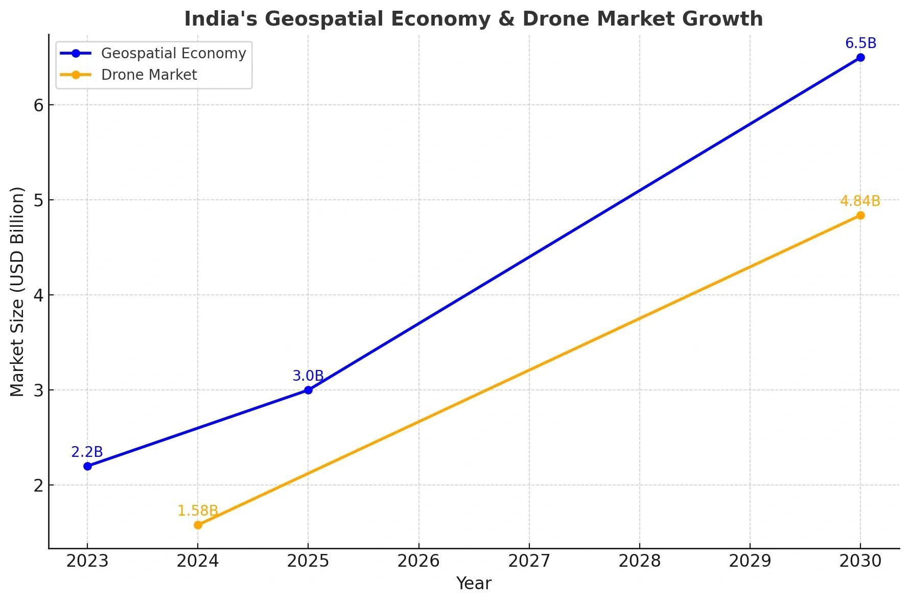
India’s geospatial analytics market: USD 1.35B in 2024, set to hit USD 3.16B by 2030, CAGR ~14.8%.
A broader estimate says USD 5.2B in 2024, swelling to USD 18.8B by 2033, CAGR ~14.3%.
Drone market: USD 1.58B in 2024, headed to USD 4.84B by 2030, CAGR ~20%.
GIS tech is evolving: AI‑driven analysis, IoT integration, cloud‑based systems, open‑data trends, 3D mapping, all reshaping how spatial data is used.
Where The Real Value Lands
Even as data “democratizes,” the spoils skew:
Governments & Big Firms buy SAR, hyperspectral, high‑res imagery for precision agriculture, climate analysis, urban planning.
Marketplace intermediaries (say, a SatSure-Dhruva EOaaS model) bundle and sell. Survival depends on compliance, quality, and reach, not openness.
Drone operators ride tailwinds, not just data, but services. India’s drone market is surging, driven by PLI schemes, relaxed rules, and SVAMITVA mapping efforts.
There’s space for freelancers, but only if they can compete with quality, pricing, and trust.
Skeptic’s Timeline
Year 1-2 (Now): Platforms launch. Early adopters are tech-forward corporates.
Year 3-4: Quality control becomes critical. Many marketplaces struggle; consolidation follows.
Year 5+: Big players dominate. SMEs eke out niche roles. Spatial data becomes part of AI-fueled decision engines.
What India Must Do
To make the narrative less dystopian:
Enforce metadata, licensing clarity, update cadences.
Subsidize data access for research, rural users, and startups.
Mandate quality checks in marketplace listings.
Push API-first, low-code access models for developers.
Without these, "spatial data democratization" risks being just marketing. And we’ve seen enough of that.
Conclusion
Spatial data marketplaces are part of India’s future, but just part. The real power sits in who owns the EO infrastructure and gets to package and sell the insights. The question isn’t if data will flow, it’s who holds the tap.