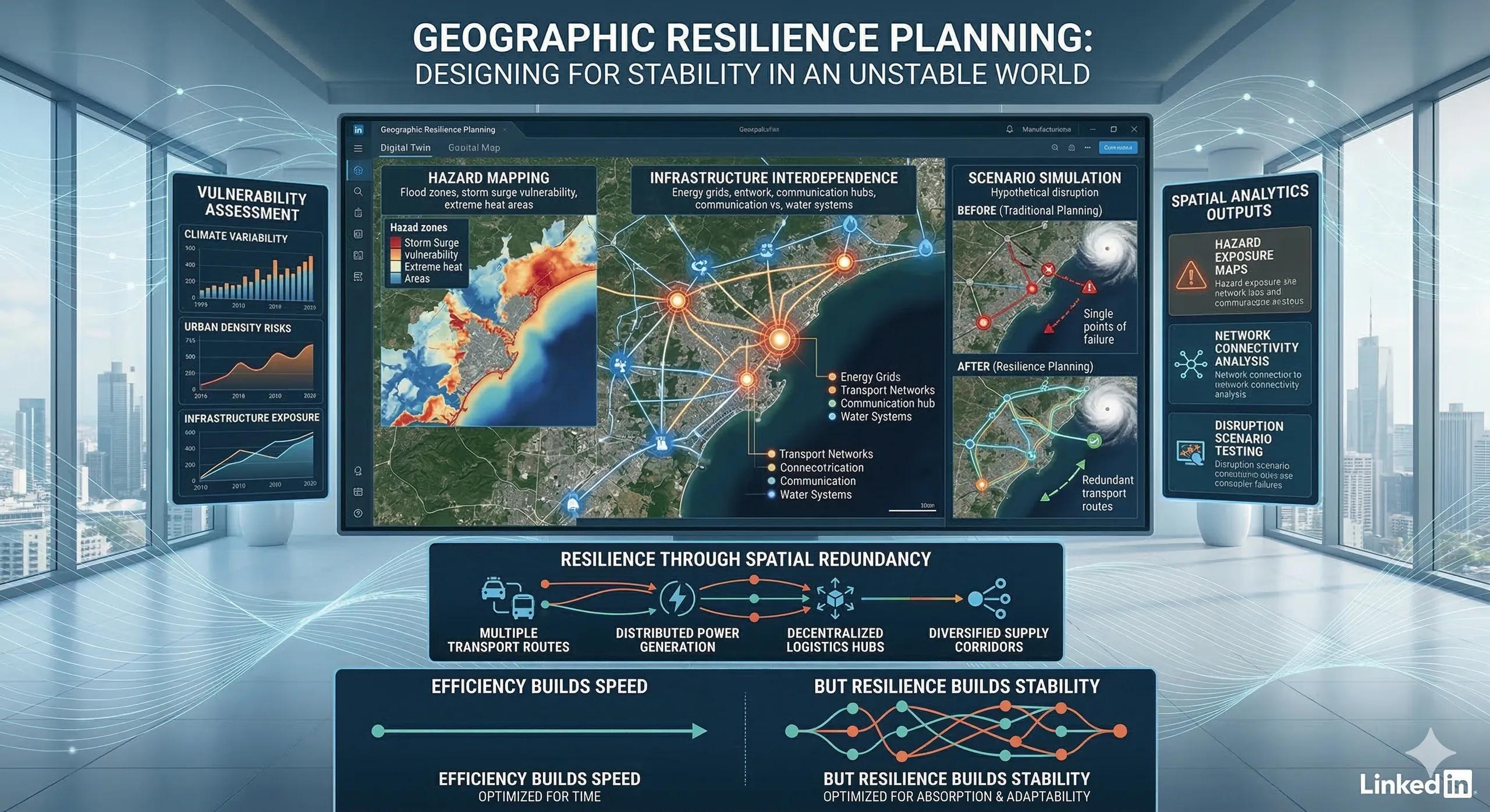
Planning for Stability in an Unstable World
For decades, infrastructure planning assumed that the future would resemble the past.
Transport systems were designed around predictable traffic flows.
Energy networks were built for stable climate patterns.
Cities expanded based on historical growth trends.
That assumption is becoming less reliable.
Extreme weather events, supply chain disruptions, and infrastructure failures are increasingly testing the stability of critical systems.
As a result, planners are beginning to adopt a different mindset:
designing systems not just for efficiency, but for resilience.
And resilience, like risk, is deeply geographic.
What Is Geographic Resilience Planning?
Geographic resilience planning focuses on understanding how spatial systems respond to disruption.
Rather than evaluating individual assets in isolation, it analyzes how entire regions behave under stress.
This includes examining:
infrastructure networks
environmental exposure
urban expansion patterns
transport dependencies
resource availability
The goal is to ensure that regions can absorb disruption, adapt, and recover quickly .
Why Traditional Planning Is No Longer Enough
Many infrastructure systems were designed using historical assumptions.
However, new realities are challenging these models:
Climate variability
Floods, droughts, and heatwaves are altering environmental conditions.
Infrastructure interdependence
Power, transport, communication, and water systems increasingly depend on each other.
Urban density
Rapid urbanization concentrates populations and infrastructure in smaller geographic areas.
These dynamics make disruptions more complex and recovery more difficult.
How Spatial Analysis Enables Resilience
Geospatial intelligence provides the tools needed to evaluate resilience across regions.
Key capabilities include:
Hazard mapping
Identifying areas exposed to floods, storms, landslides, or heat stress.
Infrastructure network analysis
Understanding how transport, energy, and water systems interact.
Scenario simulation
Testing how infrastructure systems behave under disruption scenarios.
Regional vulnerability mapping
Identifying locations where risks overlap.
When combined, these insights allow planners to design infrastructure systems that can continue functioning during disruption .
A Practical Example
Consider a rapidly growing metropolitan region planning future transport infrastructure.
Traditional planning might prioritize:
traffic demand
travel time reduction
cost efficiency
Geographic resilience planning would also evaluate:
flood exposure along transport corridors
alternative routes for emergency access
redundancy in logistics networks
proximity to critical infrastructure nodes
This approach ensures that mobility remains functional even during disruptions.
Resilience Through Spatial Redundancy
One of the most effective strategies in resilience planning is geographic redundancy .
Examples include:
multiple transport routes connecting key regions
distributed power generation instead of centralized plants
decentralized logistics hubs
diversified supply corridors
Redundancy may appear inefficient during normal operations, but it becomes invaluable during crises.
The Monetization Bridge
Governments, infrastructure operators, and large enterprises are increasingly adopting geospatial analytics and digital twin platforms to simulate disruption scenarios, evaluate regional vulnerability, and design infrastructure networks capable of maintaining service continuity during environmental, operational, or geopolitical shocks.
Looking Ahead
Geographic resilience planning will play a growing role in:
climate adaptation strategies
infrastructure investment decisions
disaster preparedness planning
urban development policies
supply chain design
Regions that integrate spatial intelligence into planning will be better prepared for uncertainty.
Closing Insight
Efficiency builds speed.
But resilience builds stability.
In an increasingly uncertain world, the most successful infrastructure systems will be those designed with geographic resilience in mind .