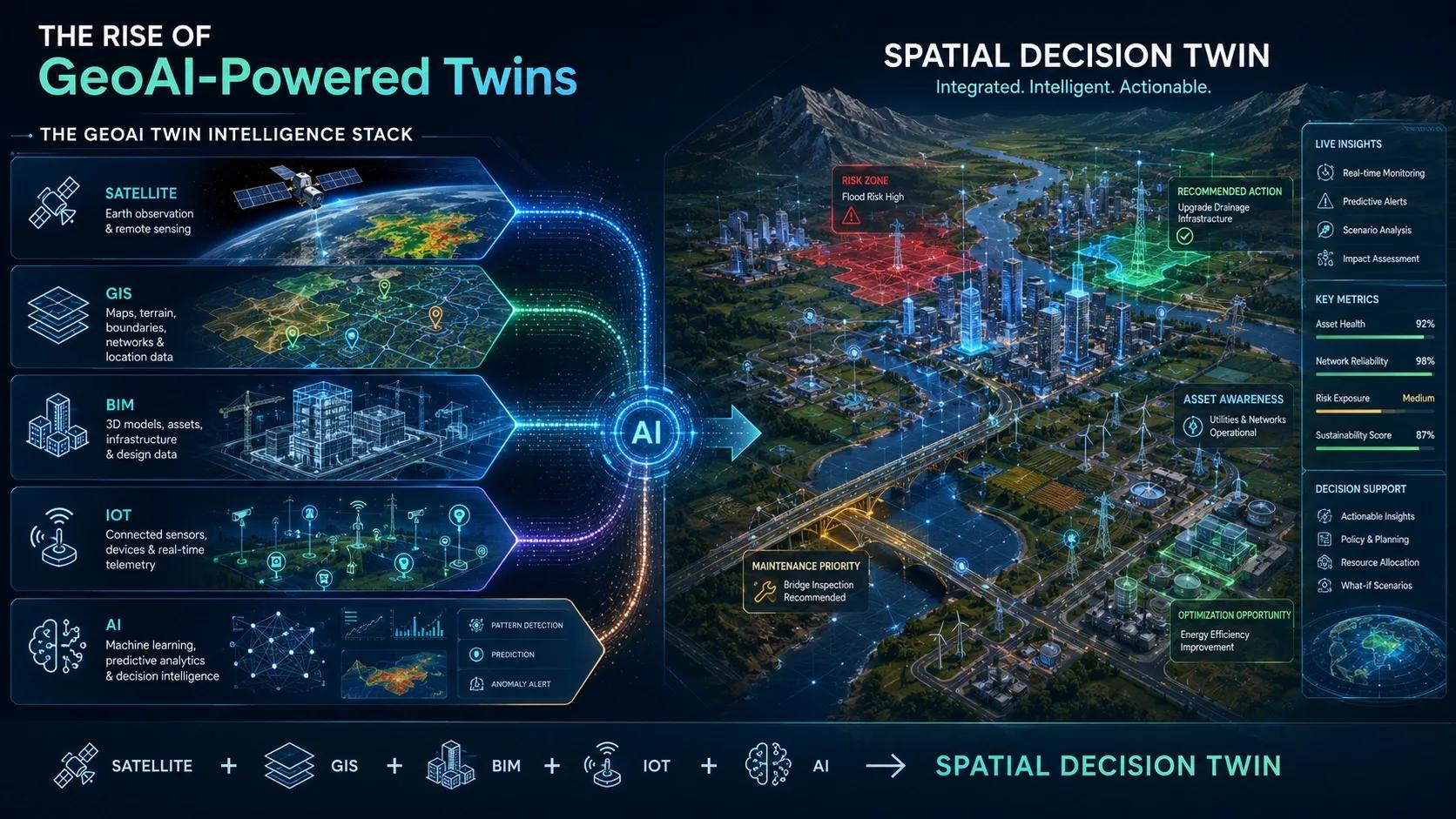
A Digital Twin without spatial intelligence can show what is happening.
A GeoAI-powered Twin can help explain where, why, and what may happen next .
Introduction: Phase 5 Continuation
In Phase 5, we are exploring the future and strategic direction of Digital Twins.
So far, we have discussed:
AI-driven autonomous Digital Twins
event-driven architectures
Digital Twins with XR
Edge AI and on-site decision systems
Now we move to a capability that is especially important for infrastructure, cities, environment, logistics, utilities, agriculture, mining, defense, and disaster management:
GeoAI-Powered Digital Twins
GeoAI combines:
geospatial data
artificial intelligence
remote sensing
IoT data
spatial analytics
predictive modelling
A traditional Digital Twin may represent an asset, system, or process.
But a GeoAI-powered Twin understands that every asset exists within a larger spatial context.
Because in the real world:
👉 location changes everything.
What Is a GeoAI-Powered Twin?
A GeoAI-powered Twin is a Digital Twin where geospatial intelligence and AI are deeply integrated into the system.
It does not only answer:
👉 What is happening?
It also answers:
👉 Where is it happening?
👉 Why is it happening there?
👉 What spatial patterns are emerging?
👉 What areas are at risk?
👉 What action should happen next?
This is especially useful when decisions depend on terrain, land use, accessibility, climate, infrastructure networks, population distribution, environmental exposure, and movement patterns.
Why GeoAI Matters
Many Digital Twin systems are built around assets.
For example:
a building
a factory
a bridge
a machine
a port
a power plant
But many real decisions are not asset-only decisions.
They are spatial decisions.
Examples:
Where will flood impact be highest?
Which road segment needs maintenance first?
Which hospital location can serve the largest population?
Which mining zone carries environmental risk?
Which telecom tower needs capacity expansion?
Which agricultural zone needs irrigation?
Which logistics route is most vulnerable?
GeoAI adds the spatial intelligence required to answer these questions.
The Core Shift: From Asset Twin to Spatial Decision Twin
A conventional Digital Twin may show the condition of an asset.
A GeoAI-powered Twin connects that asset to its environment.
For example:
A road Digital Twin may show:
pavement condition
traffic load
maintenance status
But a GeoAI-powered road twin can also analyze:
rainfall exposure
flood-prone stretches
soil conditions
nearby drainage
accident hotspots
traffic movement patterns
surrounding land use
That changes the decision from:
👉 “This asset has a problem.”
to:
👉 “This location has a recurring risk pattern.”
That is a deeper form of intelligence.
Key Data Layers in GeoAI-Powered Twins
GeoAI-powered Twins combine multiple spatial and operational datasets.
1. Remote Sensing Data
This includes:
satellite imagery
SAR data
optical imagery
thermal imagery
vegetation indices
land cover classification
Useful for:
agriculture
forestry
mining
disaster response
urban monitoring
environmental compliance
2. GIS Data
This includes:
roads
buildings
utilities
land parcels
administrative boundaries
terrain
drainage
transport networks
GIS provides the spatial structure.
3. IoT and Sensor Data
This includes:
asset health sensors
environmental sensors
water level sensors
energy meters
weather stations
mobility sensors
IoT brings live operational signals into the spatial model.
4. BIM and Engineering Data
This includes:
asset geometry
design information
construction details
maintenance attributes
material information
BIM adds engineering depth.
5. Socioeconomic and Mobility Data
This includes:
population density
travel time
footfall
accessibility
demand patterns
service coverage
This is critical for healthcare, retail, smart cities, and public infrastructure.
Where GeoAI Creates Value
1. Predictive Risk Mapping
GeoAI can identify where risks are likely to emerge.
Examples:
flood-prone zones
landslide risk areas
road damage hotspots
fire risk zones
environmental compliance risks
This helps organizations move from reactive response to proactive planning.
2. Automated Change Detection
GeoAI can detect changes across large areas.
Examples:
land use change
deforestation
illegal mining
encroachment
construction progress
crop stress
shoreline change
This is valuable because manual monitoring at scale is difficult.
3. Location-Based Optimization
GeoAI helps optimize where actions should happen.
Examples:
where to locate a new hospital
where to place telecom towers
where to prioritize road repairs
where to deploy emergency teams
where to build renewable energy assets
This turns Digital Twins into planning intelligence systems.
4. Climate and Resilience Planning
GeoAI-powered Twins can combine environmental data with infrastructure systems.
This enables:
flood simulations
heat stress mapping
coastal risk analysis
drought monitoring
urban resilience planning
For countries like India, this is highly relevant.
5. Asset and Network Intelligence
Many infrastructure systems are networks, not isolated assets.
Examples:
roads
railways
pipelines
power grids
telecom networks
drainage systems
GeoAI helps analyze how one location affects another.
That is where Digital Twins move from asset monitoring to network intelligence.
Practical Example: Flood Management
A traditional flood monitoring system may show water levels.
A GeoAI-powered flood twin can integrate:
rainfall forecast
river levels
terrain model
drainage networks
land use
population exposure
road accessibility
shelter locations
Then AI can predict:
where water may spread
which communities are exposed
which roads may fail
where evacuation routes are still usable
which response teams should move first
This is not just flood visualization.
It is spatial decision intelligence.
Practical Example: Agriculture
A farm Digital Twin may show crop health.
A GeoAI-powered farm twin can connect:
satellite imagery
soil moisture
weather forecast
irrigation zones
crop type
terrain slope
pest risk
yield history
This allows zone-wise decisions:
where to irrigate
where to apply fertilizer
where crop stress is emerging
where yield loss may occur
The field stops being treated as an average.
It becomes a spatially intelligent operating system.
Practical Example: Smart Cities
A smart city Digital Twin may show buildings and infrastructure.
A GeoAI-powered city twin can analyze:
mobility patterns
land use changes
utility demand
heat islands
traffic congestion
flood exposure
emergency response coverage
public service accessibility
This helps cities move from dashboards to coordinated planning.
The Role of AI Agents in GeoAI Twins
The next step is the rise of GeoAI agents.
These agents can help users ask questions such as:
Which areas are most exposed to flood risk this week?
Which road segments should be inspected first?
Where should we place a new facility?
Which assets are vulnerable due to terrain and weather?
Which land parcels have changed unexpectedly?
The power lies in combining natural language, maps, spatial analytics, and operational data.
This makes geospatial intelligence more accessible to decision-makers.
Where Most Implementations Fail
1. Treating GIS as Only a Map Layer
GIS should not be treated as a background map.
It should be a decision layer.
2. Poor Spatial Data Quality
Incorrect coordinates, outdated boundaries, and inconsistent asset locations can damage trust.
3. No Integration Between BIM, GIS, IoT, and AI
Many systems remain disconnected.
GeoAI needs integrated context.
4. Lack of Operational Workflows
Spatial insights must trigger action.
Otherwise, they remain maps.
5. Limited Domain Context
AI models need domain understanding.
A flood model, farm model, mining model, and telecom model need different spatial logic.
Indian Context
India is a strong candidate for GeoAI-powered Twins because the country faces complex spatial challenges:
rapid urbanization
climate risk
flood-prone regions
infrastructure expansion
agricultural variability
land use conflicts
utility network complexity
healthcare access gaps
logistics bottlenecks
India also has growing digital infrastructure, satellite capability, smart city initiatives, and GIS-based planning systems.
The opportunity is to move from:
👉 mapping assets
to
👉 using spatial intelligence for operational decisions.
This can support:
smarter infrastructure planning
better disaster preparedness
precision agriculture
environmental monitoring
improved healthcare access
utility resilience
urban governance
Benefits of GeoAI-Powered Twins
better spatial decision-making
improved risk prediction
large-scale change detection
stronger planning intelligence
better resource allocation
improved climate resilience
faster response to emerging events
higher ROI from geospatial and Digital Twin investments
Conclusion
The future of Digital Twins will not be only asset-centric.
It will be spatially intelligent.
GeoAI-powered Twins bring together:
👉 location
👉 context
👉 prediction
👉 simulation
👉 action
They allow organizations to understand not just what is happening, but where it matters most.
This is the shift from:
👉 Digital Twin as a model
To
👉 GeoAI-powered Twin as a spatial decision system.
For sectors like infrastructure, cities, agriculture, disaster management, mining, utilities, and healthcare, this may become one of the most important next-generation capabilities.
Because in the physical world, every decision has a location.