Opening Reflection
Every digital transformation journey eventually reaches the same wall: data silos.
A building model exists in BIM. A terrain layer exists in GIS. A UAV survey creates another 3D output. IoT sensors stream live data into dashboards. XR teams rebuild the same environment for immersive walkthroughs. AI teams create separate simulation models for training and testing.
Each system may be powerful on its own. But together, they often behave like disconnected islands.
This is one of the biggest challenges in building meaningful digital twins.
The problem is not only that data is stored in different formats. The deeper issue is that spatial information is often unable to evolve together. When a model changes in one system, another team must export, convert, re-import, and rebuild its workflow. In that process, data quality may be lost, context may be broken, and collaboration slows down.
This is where Universal Scene Description, or OpenUSD, becomes important .
At first glance, OpenUSD may appear to be just another 3D format. But that would be a limited view. OpenUSD is not only about storing 3D geometry. It is about composing complex digital environments in a way that different teams, tools, and data layers can work together.
For the future of digital twins, spatial computing, BIM-GIS integration, XR, and AI simulation, this could be a very important shift.
The Technological Shift: From 3D Files to Composable Spatial Worlds
Most traditional 3D formats were designed to store objects.
They define geometry, materials, textures, and sometimes animation. These formats are useful, but they often treat a 3D model as a fixed output. Once exported from one platform and imported into another, the model becomes disconnected from its source.
This is common in BIM-to-XR or BIM-to-game-engine workflows.
A Revit model may be exported into another format, cleaned up, optimized, and imported into Unreal or Unity. But when the original design changes, the same process often has to be repeated. This is what makes the workflow destructive. The model moves forward, but the intelligence behind it does not always travel with it.
OpenUSD introduces a different way of thinking.
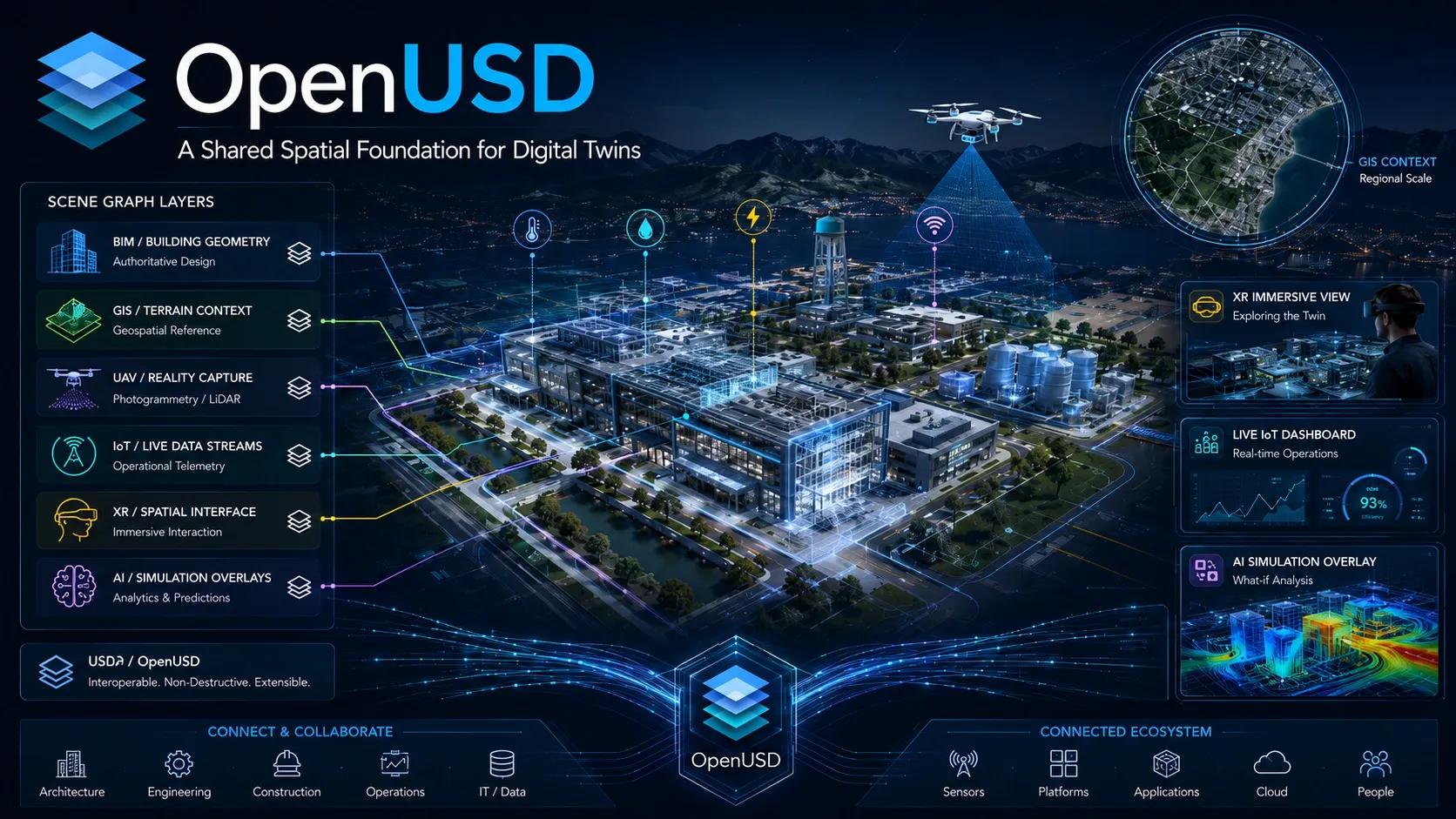
It allows a scene to be built through layers, references, variants, and non-destructive edits. Instead of treating the 3D environment as one rigid file, it treats it as a composition.
This means different contributors can work on different layers of the same environment.
The architect may author the building geometry.
The geospatial engineer may add terrain and coordinate context.
The digital twin team may connect IoT data streams.
The XR team may create an immersive experience.
The AI team may generate simulation scenarios.
Each layer can evolve without forcing the whole environment to be rebuilt from scratch.
That is the technological shift.
We are moving from static 3D files to composable spatial worlds.
The Deeper Question: Are We Building Models or Shared Spatial Systems?
For many organizations, the digital twin journey starts with visualization.
They want to see the asset in 3D. They want a dashboard. They want an immersive view. They want a model that looks like the real world.
There is nothing wrong with that. Visualization helps people understand complex environments faster.
But a digital twin cannot stop at visual representation.
The deeper question is: Are we building models, or are we building shared spatial systems?
A model may show a building.
A shared spatial system can connect design, location, operations, sensors, simulations, and decisions.
A model may be impressive during a presentation.
A shared spatial system remains useful across the asset lifecycle.
A model may answer, “What does this asset look like?”
A shared spatial system asks, “How is this asset changing, performing, and interacting with its environment?”
This distinction matters.
Because large infrastructure owners, smart city teams, industrial operators, airport authorities, utilities, and real estate portfolios do not struggle because they lack models. They struggle because their digital assets are fragmented across departments, vendors, software platforms, and project phases.
OpenUSD does not magically solve every interoperability issue. Standards, metadata, governance, coordinate systems, cybersecurity, and domain-specific semantics still matter.
But OpenUSD gives us a technical foundation to think beyond single-purpose models.
It supports the idea that a spatial environment can be assembled, extended, updated, and reused across multiple workflows.
That is where its strategic value lies.
The Spatial Intelligence Perspective
From a GeoThinking perspective, OpenUSD is not just a 3D technology topic. It is a spatial intelligence topic.
Geospatial thinking is based on relationships.
A road is not only a line. It is connected to drainage, land use, traffic movement, utilities, accident risk, climate exposure, and maintenance history.
A building is not only a structure. It is connected to people, systems, energy, ventilation, safety, workflows, assets, and surrounding infrastructure.
A factory is not only a production unit. It is a spatial network of machines, operators, inventory, logistics, energy flows, quality checkpoints, and safety zones.
The challenge is that these relationships are usually distributed across different data environments.
BIM captures detailed asset information. GIS captures location and network context. UAVs and LiDAR capture field reality. IoT captures live behavior. AI models capture prediction. XR captures human experience.
But digital twins need these layers to come together.
OpenUSD can act as a composition layer where different spatial and operational datasets can coexist in a more flexible structure. This does not mean replacing BIM, GIS, IFC, databases, or game engines. Instead, it can help organize how these systems contribute to a common digital environment.
This is important because the future of spatial intelligence will not depend only on collecting more data.
It will depend on how well we can compose, connect, and activate that data.
Real-World Implication: BIM, GIS, XR, and AI Simulation
The practical implications of OpenUSD are significant across multiple sectors.
Consider a smart campus digital twin.
The building models may come from BIM. The land parcels, roads, trees, utilities, and drainage may come from GIS. The latest site condition may come from UAV photogrammetry or LiDAR. Occupancy and energy data may come from IoT sensors. Emergency planning may require simulation. Training may require XR walkthroughs.
Traditionally, each use case may require its own version of the model.
But with an OpenUSD-based approach, the campus can be treated as a layered spatial environment. The same base scene can support design review, facility operations, XR training, energy analysis, and future AI simulation.
Now consider an industrial plant.
Machine layouts, production zones, worker movement, safety areas, material flow, robotic cells, inspection points, and energy systems can all be represented as part of a broader operational scene. AI teams can create synthetic variations of the plant to train machine vision systems or autonomous robots. XR teams can use the same environment for operator training. Maintenance teams can overlay live sensor data.
This is where OpenUSD becomes valuable.
It creates a path for digital twin environments to become reusable across many applications instead of being rebuilt repeatedly.
For UAV and reality capture workflows, this is also important. A highly detailed field scan can coexist with an engineering model. This allows teams to compare planned versus actual conditions, detect deviations, and understand field reality without forcing everything into one limited format.
For XR, OpenUSD is already relevant through USDZ and spatial computing workflows. The digital twin created for operational monitoring could also become the foundation for immersive review, training, or remote collaboration.
For AI and machine learning, OpenUSD enables simulation-rich environments. AI systems require large volumes of training data, and real-world data is not always enough. Synthetic environments can help generate different scenarios, lighting changes, weather conditions, asset defects, traffic patterns, safety events, or structural anomalies.
This makes OpenUSD not only a 3D composition framework, but also a foundation for future AI-ready spatial systems.
Insight: The Digital Twin Is Becoming a Shared Operating Environment
The key insight is this:
The digital twin is moving from a model to a shared operating environment.
In the early stage, digital twins were often treated as visual replicas. The focus was on creating a 3D representation of an asset.
In the next stage, digital twins became connected dashboards. The focus shifted to linking sensor data, asset information, and operational metrics.
Now, the direction is changing again.
The next generation of digital twins will need to support simulation, collaboration, AI training, XR interaction, lifecycle updates, and cross-platform interoperability.
That means the underlying architecture must be flexible.
OpenUSD supports this direction because it allows multiple layers of information to be composed without destroying the original structure. It enables different teams to work within the same spatial context while maintaining their own contributions.
This is especially important for large asset ecosystems.
Airports, highways, industrial plants, smart cities, energy networks, ports, campuses, and logistics hubs are not static assets. They constantly change. New systems are added. Existing systems are upgraded. Field conditions shift. Operational priorities evolve.
A digital twin that cannot absorb change becomes outdated quickly.
A digital twin that is built as a shared operating environment can continue to grow.
That is why OpenUSD should be seen not only as a technical format, but as an architectural mindset.
It encourages us to ask:
Can this environment evolve?
Can multiple teams contribute?
Can future systems connect?
Can field reality update the model?
Can AI and XR use the same foundation?
Can we reduce repeated conversion and rework?
These questions are becoming central to digital twin strategy.
Closing Reflection
The future of spatial technology will not be defined only by better visuals.
It will be defined by better connections.
We already have powerful tools for BIM, GIS, UAV mapping, LiDAR, IoT, XR, AI, and simulation. But the real value will come when these tools are able to work together around shared spatial context.
OpenUSD points toward that future.
It reminds us that the next generation of digital infrastructure cannot be built as isolated files, models, or dashboards. It must be built as a connected environment where different layers of reality can coexist, evolve, and support decisions.
For organizations, this means the digital twin discussion must move beyond “Can we create a 3D model?”
The better question is:
Can we create a spatial foundation that remains useful as technology, operations, and decisions evolve?
That is where OpenUSD becomes more than a format.
It becomes a bridge between design and operations, between field reality and simulation, between human experience and machine intelligence.
And perhaps that is the real shift ahead.
We are no longer just building digital representations of the world.
We are building shared spatial environments where the world can be understood, tested, experienced, and improved.