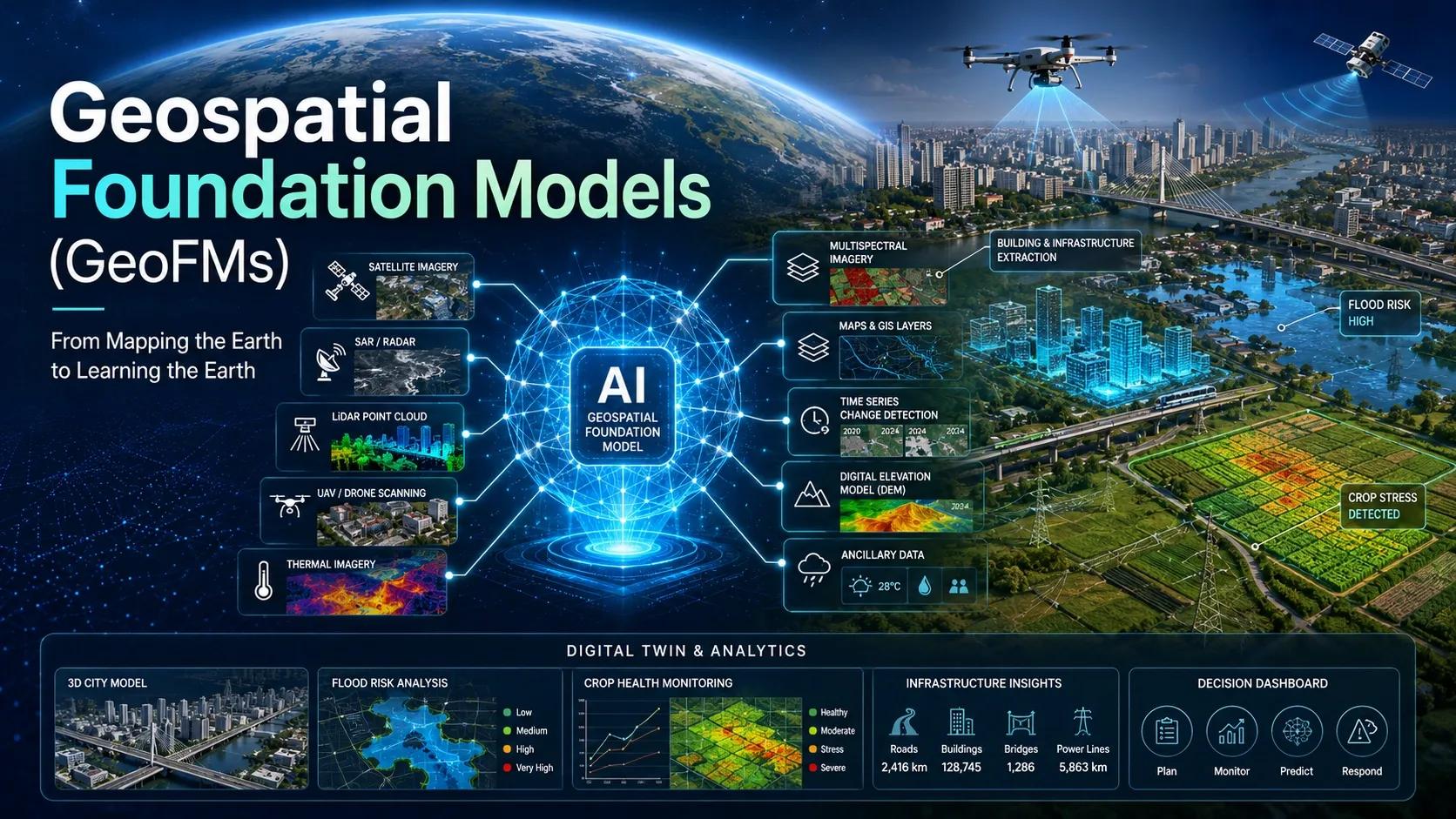
Opening Reflection
For decades, geospatial intelligence has depended on one basic pattern: collect data, clean it, label it, train a model, validate the output, and then repeat the same cycle for every new use case.
One model for crop stress.
Another for flood mapping.
Another for building extraction.
Another for deforestation.
Another for road damage.
This approach worked, but it was slow, expensive, and difficult to scale.
Now, geospatial AI is entering a different phase. The shift is not just about better algorithms. It is about a new foundation for how machines understand the Earth.
This is where Geospatial Foundation Models , or GeoFMs , become important.
The attached concept rightly describes this as a possible “ChatGPT moment for Earth Observation,” because the change is similar: instead of training an AI model from scratch for every task, we begin with a large model that has already learned patterns from massive Earth observation datasets.
The Technological Shift: From Task-Specific AI to Earth-Learned Models
Traditional geospatial AI is usually narrow.
It is trained for a specific task using labeled datasets. For example, to detect diseased crops from drone imagery, the model needs many examples of healthy and unhealthy crops. To detect damaged roofs after a storm, another model must be trained with another dataset. To classify water bodies, roads, buildings, vegetation, or bare soil, the same cycle repeats.
This creates three practical problems.
First, data labeling becomes a bottleneck.
Second, models often fail when geography changes.
Third, every new use case starts almost from zero.
GeoFMs change this pattern.
A Geospatial Foundation Model is trained on large volumes of satellite, UAV, multispectral, temporal, and sometimes multi-sensor data. Instead of learning only one category, it learns broader Earth patterns: vegetation cycles, built-up expansion, water movement, terrain behaviour, seasonal variation, atmospheric influence, and land-cover relationships.
IBM and NASA’s Prithvi-EO-2.0 is a useful reference point. IBM describes it as a 600-million-parameter geospatial foundation model, six times larger than the earlier Prithvi model, with stronger ability to understand relationships across time and space. The Prithvi-EO-2.0 paper also notes that it was trained on global time-series samples from NASA’s Harmonized Landsat and Sentinel-2 archive, with temporal and location embeddings to improve performance across geospatial tasks.
That matters because geography is never static.
A field is not just a field. It changes with season, rainfall, soil condition, crop cycle, irrigation pattern, and human intervention. A city is not just a collection of buildings. It expands, densifies, heats up, floods, and consumes energy differently over time.
GeoFMs begin to learn this living behaviour of the Earth.
The Deeper Question: Are We Building Models, or Building Spatial Understanding?
The deeper question is this:
Are we simply automating image interpretation, or are we building systems that understand place?
This distinction matters.
A conventional AI model may detect a building.
A GeoFM can help understand how that building sits within a changing urban system.
A conventional model may classify vegetation.
A GeoFM can support analysis of seasonal stress, land-use change, moisture patterns, and climate-linked risk.
A conventional model may detect water.
A GeoFM can support flood mapping, drainage risk, wetland monitoring, or drought assessment with less task-specific training.
This is why GeoFMs should not be seen only as another AI tool. They represent a shift in how geospatial intelligence is created.
They move us from isolated detection toward reusable spatial intelligence.
The Spatial Intelligence Perspective
From a GeoThinking perspective, GeoFMs strengthen one of the most important ideas in digital transformation: context is intelligence .
A location does not gain value only because it appears on a map. It gains value when it is connected to time, behaviour, risk, infrastructure, environment, and decision-making.
GeoFMs can help connect these layers.
They can support sensor fusion by combining satellite imagery, UAV data, LiDAR, SAR, thermal data, and field inputs into a more coherent analytical layer. They can reduce the dependence on large labeled datasets. They can also make it easier to fine-tune solutions for local conditions.
For businesses, this has direct value.
A utility company could use GeoFMs to monitor vegetation risk near transmission lines.
A city authority could map flood-prone urban areas faster.
A logistics company could assess land-use change near transport corridors.
An agriculture enterprise could detect crop stress earlier.
An infrastructure company could compare construction progress with environmental risk.
A mining company could monitor land disturbance and restoration.
The model does not replace geospatial expertise. It increases the speed at which geospatial expertise can be applied.
That is the key point.
GeoFMs do not remove the need for domain knowledge, field validation, data governance, or local understanding. They create a stronger starting point.
Real-World Implication: Digital Twins, UAVs, and Decision Systems
The real opportunity appears when GeoFMs are connected to digital twins.
Many digital twin projects still struggle because they depend on fragmented data. BIM models sit in one system. GIS layers sit in another. IoT data flows separately. UAV surveys are processed as periodic reports. Satellite imagery is used as background context rather than an active intelligence layer.
GeoFMs can help change that.
Imagine a city-scale digital twin where the model does not only show buildings, roads, and drains, but continuously interprets land-cover change, flood exposure, heat islands, construction activity, vegetation loss, and infrastructure stress.
Imagine an agriculture digital twin where UAV imagery, satellite time series, weather data, soil data, and field observations are interpreted together to predict crop stress or irrigation needs.
Imagine a coastal monitoring platform where SAR, optical imagery, AIS signals, and weather patterns are analyzed together to detect unusual vessel movement, shoreline change, or flood exposure.
This is where GeoFMs move from research to business relevance.
They can shorten development timelines, reduce repeated model-building effort, and improve the scalability of geospatial AI solutions. They also support the rise of conversational GIS , where users may eventually ask natural-language questions such as:
“Show me industrial zones in Hyderabad with high flood exposure.”
“Identify villages where crop stress increased over the last three weeks.”
“Find road corridors where surface condition is degrading faster than expected.”
“Highlight assets where land-use change may create compliance risk.”
This is not just a better dashboard.
It is a more intelligent decision interface.
Insight: The Future of Geospatial AI Is Reusable Intelligence
The biggest business value of GeoFMs is not only accuracy. It is reuse.
A foundation model allows organizations to build faster because the model already has a base understanding of Earth observation patterns. Fine-tuning becomes easier. Deployment becomes faster. Use cases become more scalable.
For entrepreneurs, consultants, and technology providers, this opens a new service model.
Instead of selling only custom AI development, the value can shift toward:
problem framing
data readiness assessment
fine-tuning for local use cases
workflow integration
digital twin intelligence layers
decision dashboards
governance and validation
sector-specific deployment
This is important for markets like India, where geospatial adoption is growing, but many organizations still hesitate because of cost, complexity, and unclear ROI.
GeoFMs can reduce the entry barrier.
But there is also a caution.
A foundation model is not automatically a business solution. The model still needs clean workflows, proper data pipelines, local calibration, user adoption, and decision accountability. Without this, even the most advanced AI remains another technical experiment.
The goal should not be to use GeoFMs because they are new.
The goal should be to use them where they improve decisions.
Closing Reflection
Geospatial Foundation Models mark an important step in the evolution of spatial intelligence.
They take us beyond narrow detection models and move us toward AI systems that can learn from the Earth at scale. They can read patterns across geography, time, and sensor types. They can support digital twins, climate intelligence, infrastructure monitoring, agriculture planning, and urban governance.
But their real promise lies in how we apply them.
The future of geospatial AI will not be defined only by who has the largest model. It will be defined by who can convert these models into trusted, local, decision-ready systems.
Because in the end, the value of geospatial intelligence is not in seeing the Earth more clearly.
It is in making better decisions from what we see.