For years, the digital twin conversation has been shaped by one central question: how accurately can we recreate the physical world in digital form?
But a deeper question is now emerging:
What happens when the digital version of reality no longer looks like a technical model, but like the world itself?
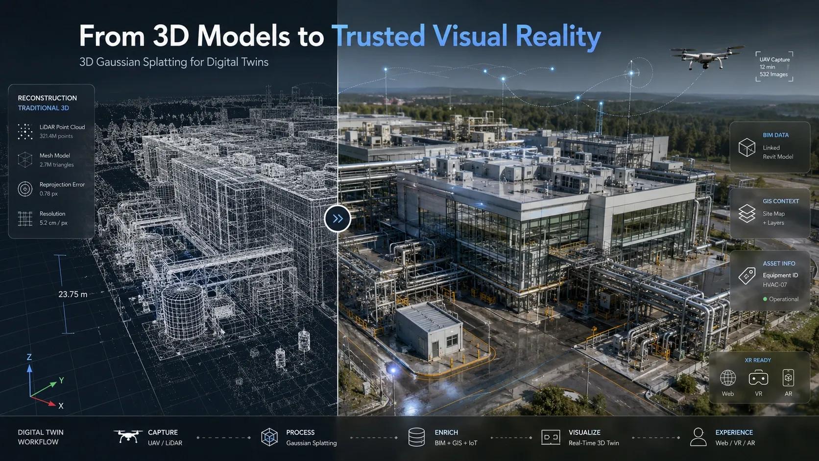
This is where 3D Gaussian Splatting , or 3DGS , becomes important. It is not just another 3D reconstruction method. It represents a shift in how we capture, render, and experience physical environments. The concept highlights how 3DGS moves beyond traditional polygon meshes and point clouds by using millions of semi-transparent 3D “splats” to create a photorealistic and real-time representation of a scene.
For geospatial professionals, BIM teams, UAV operators, XR developers, and digital twin practitioners, this matters because the future of spatial intelligence will not depend only on coordinates, layers, and measurements. It will also depend on how naturally humans can understand and trust the digital environment in front of them.
The Technological Shift: From Geometry to Visual Reality
Traditional 3D reconstruction has largely depended on two familiar approaches.
The first is photogrammetry , where images captured from multiple angles are processed to create 3D geometry. The second is LiDAR , where laser scanning produces dense and highly accurate point clouds.
Both are powerful. Both will remain important.
But both also have limitations.
Photogrammetry struggles when surfaces lack strong visual features. Reflective glass, shiny metal, complex cables, transparent materials, and repetitive textures can break the reconstruction process. LiDAR gives strong geometry, but the visual experience often remains technical. A point cloud may be accurate, but it does not always feel like the actual site.
3D Gaussian Splatting introduces a different logic.
Instead of building the world mainly through hard surfaces and polygon meshes, 3DGS represents a scene through millions of small, overlapping, semi-transparent 3D ellipsoids. Each splat carries position, scale, rotation, opacity, and color. When rendered together, they produce a continuous, photorealistic scene.
This means a building facade, industrial plant, construction site, campus, or heritage structure can be experienced not just as a geometric model, but as a visually rich environment.
That is a major shift.
Because in many operational contexts, people do not make decisions from geometry alone. They make decisions from visual understanding .
The Deeper Question: Are We Building Models or Experiences?
A digital twin is often defined as a digital replica of a physical asset, system, or process. But in practice, many digital twins still look like dashboards, 3D viewers, or technical models.
They are useful, but they can feel disconnected from human perception.
3DGS challenges this gap.
It asks us to think beyond the question: “Can we model the asset?”
And move toward: “Can we recreate the experience of being there?”
This distinction is important.
For a site engineer, facility manager, safety officer, urban planner, or client stakeholder, the value of a digital twin is not only in technical accuracy. It is in how quickly the person can understand the current state of the asset, identify risk, discuss decisions, and act with confidence.
A photorealistic environment reduces interpretation effort. It helps non-technical stakeholders engage with complex spaces. It gives teams a shared visual reference.
This is where 3DGS becomes more than a rendering technique. It becomes a communication layer between the physical world and human decision-making.
The Spatial Intelligence Perspective
From a GeoThinking lens, 3DGS should not be seen as a replacement for LiDAR, BIM, GIS, or photogrammetry. That would be too narrow.
Its real value lies in the hybrid workflow .
LiDAR can provide geometric accuracy.
BIM can provide structured asset information.
GIS can provide location context.
IoT can provide live operational data.
AI can detect changes, patterns, and risks.
XR can create immersive interaction.
And 3DGS can provide the photorealistic visual layer that makes the digital twin feel closer to physical reality.
This is where the next generation of digital twins will evolve.
Not as one technology replacing another, but as a fused environment where each layer serves a different purpose.
For example, in an industrial facility, LiDAR may define the exact position of pipes, machines, and structures. BIM may hold asset metadata. IoT may show temperature, vibration, energy, or occupancy. GIS may connect the facility to its wider logistics and environmental context. 3DGS may then allow decision-makers to walk through the site visually, with lighting, reflections, and real-world texture preserved.
That combination can make digital twins more usable, more intuitive, and more decision-ready.
Real-World Implication: UAVs, XR, and Field Reality
The most immediate impact of 3DGS may be seen in UAV-based reality capture and XR-based digital twin experiences.
Today, drone surveys are widely used for construction monitoring, infrastructure inspection, mining, urban planning, and asset documentation. But the outputs often require expert interpretation. Orthomosaics, point clouds, meshes, and textured models are valuable, but they are not always easy for every stakeholder to read.
3DGS can change that.
A drone video or image set can be converted into a navigable, photorealistic 3D scene much faster than many traditional neural rendering approaches. Because 3DGS supports real-time rendering, it can make immersive walkthroughs smoother and more accessible on standard GPUs.
For client presentations, this is powerful.
Instead of showing a static model or a heavy point cloud, teams can present a real-time visual environment that feels close to the actual site. For construction progress reviews, this can help compare planned versus actual conditions. For industrial inspections, it can help reduce visual noise caused by broken photogrammetry. For smart city planning, it can help leaders understand urban spaces without needing to interpret abstract technical data.
The value is not just better visuals.
The value is faster comprehension.
Insight: The Digital Twin Is Moving Closer to Human Perception
The deeper meaning of 3DGS is not that it creates beautiful 3D scenes.
The deeper meaning is that it brings digital twins closer to how humans naturally perceive the world.
Humans do not experience reality as point clouds.
We do not walk through buildings as polygon meshes.
We understand space through light, texture, depth, movement, reflection, and context.
When digital twins begin to capture these qualities, they become more than technical systems. They become environments for shared understanding.
This matters because digital transformation often fails when technology becomes too abstract for the people expected to use it. A system may be technically advanced, but if users cannot understand it quickly, adoption suffers.
3DGS has the potential to reduce that gap.
It can make digital twins more relatable to field teams, executives, clients, regulators, and citizens. It can support training, inspection, planning, stakeholder engagement, and immersive decision-making.
But we must also be clear.
Photorealism is not the same as truth.
A 3DGS scene may look real, but for engineering-grade decisions, it still needs to be connected with accurate survey control, LiDAR, BIM data, metadata, timestamps, and validation workflows.
The future is not just about realistic digital twins.
It is about trusted realistic digital twins .
Closing Reflection
3D Gaussian Splatting marks a new stage in the evolution of spatial computing.
It reminds us that the future of geospatial technology will not be built only on maps, models, and measurements. It will also be built on experience, perception, and trust.
As digital twins become more common across infrastructure, cities, industries, campuses, and public systems, the winners will not be those who simply create more data. The winners will be those who make reality easier to understand, explore, validate, and act upon.
3DGS gives us a glimpse of that future.
A future where UAVs do not just capture images.
Where BIM does not just define assets.
Where GIS does not just organize location.
Where XR does not just visualize models.
Together, they create a digital environment that feels close enough to reality for people to engage with it naturally, and structured enough for organizations to make better decisions.
That is the real promise.
Not just rendering the world.
But helping us think more clearly about it.