In recent years, geospatial technology has evolved dramatically, driven by advancements in artificial intelligence (AI) and big data analytics. Businesses today leverage AI-powered geospatial tools to gain actionable insights, automate processes, and optimize decision-making. Heliware , a leader in this space, utilizes cutting-edge AI algorithms for predictive analytics, real-time monitoring, and enhanced data visualization, positioning organizations at the forefront of these developments. As we look ahead to 2024, several trends are set to reshape the future of geospatial technology, offering exciting opportunities for industries that depend on spatial data.
AI-Powered Geospatial Analytics: Transforming the Industry
The integration of AI with geospatial data has brought transformative changes across multiple sectors, including logistics, agriculture, urban planning, and disaster management. AI-powered geospatial analytics allows businesses to extract meaningful patterns from vast datasets that traditional methods cannot handle effectively. This ability to analyze and interpret complex spatial information has revolutionized decision-making, providing accurate predictions and insights that were previously unattainable.
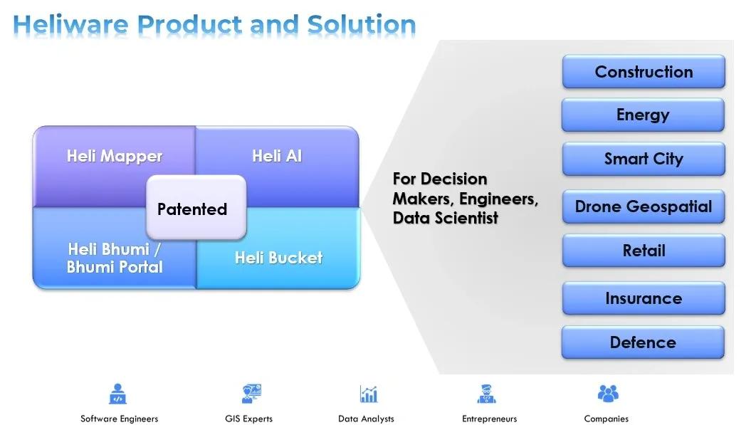
Heliware ’s AI-powered solutions, such as Heli Mapper and Heli AI, are designed to help industries harness the power of AI in geospatial applications. Through advanced machine learning (ML) algorithms, these tools can process massive amounts of geospatial data in real time, offering predictive capabilities that help businesses stay agile and responsive to changing conditions. Whether it’s monitoring agricultural yields, tracking assets in supply chains, or predicting urban growth patterns, AI-powered geospatial technology is becoming an indispensable tool for modern enterprises.
Key Trends in AI-Powered Geospatial Technology
1. Real-Time Data Processing and Predictive Analytics
One of the most prominent trends shaping the future of geospatial technology is the ability to process real-time data. AI algorithms have made it possible to analyze and interpret spatial data in real time, leading to faster and more informed decision-making. For example, in the logistics industry, AI-powered geospatial tools can track shipments and optimize routes in real time based on traffic patterns, weather conditions, and other factors.
Predictive analytics, another powerful feature enabled by AI, allows organizations to anticipate future events by analyzing historical geospatial data. By identifying trends and correlations, AI can forecast outcomes such as traffic congestion, urban expansion, or crop health, enabling proactive measures. Heliware ’s solutions, for instance, offer predictive analytics that help businesses plan for the future, reducing risks and increasing operational efficiency.
2. Automation of Geospatial Data Collection and Analysis
The automation of data collection and analysis is another major trend poised to accelerate in the coming years. Traditionally, gathering geospatial data has been labor-intensive, requiring field surveys, manual data entry, and complex processing. However, AI-powered tools have simplified this process, allowing for the automated collection and analysis of spatial data.
Unmanned Aerial Vehicles (UAVs) and satellites equipped with AI-powered sensors are now capable of capturing high-resolution geospatial data autonomously. These AI systems can also analyze the data on-the-fly, providing real-time insights without human intervention. This automation significantly reduces the time and costs associated with geospatial data collection and opens up new possibilities for industries like agriculture, where AI-enabled drones can monitor crop health, soil conditions, and water levels automatically.
3. Enhanced Data Visualization and Immersive Technologies
AI-powered geospatial technology is also transforming how data is visualized and interpreted. Traditional 2D maps and charts are giving way to more advanced forms of data visualization, including 3D models, augmented reality (AR), and virtual reality (VR) environments. These immersive technologies allow users to interact with geospatial data in ways that were previously unimaginable.
For example, urban planners can use AR to overlay real-time traffic data on top of a city map, while construction companies can use VR to simulate building designs within their geographical context. Heliware ’s Heli 3D platform enables users to visualize complex geospatial data in three dimensions, enhancing the understanding of spatial relationships and making data-driven decisions more intuitive.
4. Geospatial AI for Climate and Environmental Monitoring
As concerns over climate change and environmental sustainability grow, AI-powered geospatial technology is playing an increasingly important role in monitoring and mitigating environmental impacts. Advanced AI algorithms can analyze satellite imagery, weather data, and environmental sensors to track deforestation, monitor air and water quality, and predict natural disasters such as floods and wildfires.
Heliware ’s geospatial platforms offer real-time environmental monitoring solutions that can help governments and organizations take proactive steps to protect the environment. By leveraging AI-powered geospatial data, decision-makers can better assess environmental risks and implement policies that promote sustainability and resilience.
5. Smart Cities and Geospatial AI
The concept of smart cities is gaining momentum, and geospatial technology lies at the heart of this transformation. AI-powered geospatial tools are critical to the development and management of smart cities, as they enable real-time monitoring, predictive analytics, and efficient resource management. From optimizing public transportation systems to managing energy consumption and monitoring infrastructure health, AI-powered geospatial data is integral to the smart city ecosystem.
One of the emerging trends is the use of digital twins—virtual replicas of physical assets and environments—powered by AI. These digital twins can simulate city operations, allowing urban planners and city officials to optimize infrastructure, reduce energy consumption, and improve the quality of life for residents. Heliware ’s Heli AI platform is designed to support the development of digital twins, providing cities with the tools they need to manage and optimize their resources effectively.
6. Geospatial AI and Data Privacy Concerns
As the use of AI-powered geospatial tools becomes more widespread, concerns about data privacy and security are also growing. Geospatial data often contains sensitive information, such as the location of critical infrastructure or personal movement patterns. With the advent of AI and real-time data collection, protecting this information has become a top priority.
In response to these concerns, new data protection regulations, such as the Digital Personal Data Protection Bill in India, are being implemented to safeguard geospatial data. Organizations must ensure that their AI-powered geospatial tools comply with these regulations to protect privacy and maintain public trust.
Looking Ahead: The Future of Geospatial Technology
As we are moving ahead, AI-powered geospatial technology will continue to evolve, unlocking new opportunities and transforming industries. The ability to process real-time data, automate geospatial tasks, and deliver predictive analytics will be key drivers of this transformation. Additionally, advancements in immersive data visualization, environmental monitoring, and smart city development will further cement the importance of geospatial AI in shaping the future.
For businesses looking to stay ahead of the curve, adopting AI-powered geospatial tools like those offered by Heliware will be critical. As these technologies become more accessible and integrated into various sectors, the future of geospatial technology looks promising, with AI playing a pivotal role in driving innovation and improving operational efficiency.
In conclusion, the trends highlighted here—real-time data processing, automation, immersive visualization, environmental monitoring, smart cities, and data privacy—represent the future of AI-powered geospatial technology. By staying informed and adopting these innovations, businesses can leverage geospatial AI to gain a competitive edge in an increasingly data-driven world.