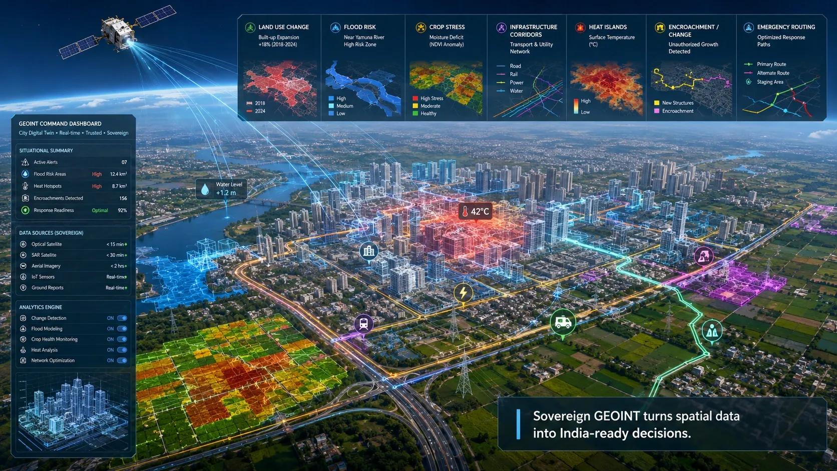
India’s geospatial sector is entering a new phase.
For years, the focus was on mapping, satellite imagery, land records, GIS databases, urban planning layers, 3D city models and infrastructure surveys. These were necessary steps. They helped create the base data required for better planning and monitoring.
But the next leap will not come from data alone.
It will come from decision intelligence.
This is where sovereign GEOINT becomes important.
GEOINT, or geospatial intelligence, is the process of converting location-based data into meaningful intelligence. It brings together satellite imagery, aerial data, GIS, terrain models, sensor feeds, AI models, field observations and operational context.
Sovereign GEOINT goes one step further. It means building geospatial intelligence systems that are designed for India’s geography, climate, infrastructure, security priorities, urban realities and economic needs.
This distinction matters.
India does not need only more satellite images. It needs intelligence systems that understand Indian conditions.
From Satellite Data to Spatial Intelligence
Satellite data is powerful. It can show crop health, urban expansion, water bodies, forest cover, road networks, coastal changes, construction activity, encroachments, floods, drought conditions and infrastructure growth.
But raw imagery is not enough for decision-making.
A municipal officer does not need only a satellite image. The officer needs to know which ward is expanding informally, where drainage stress is increasing, which roads may flood first, and which assets are exposed.
An agriculture department does not need only a vegetation index. It needs crop-stage intelligence, irrigation stress, yield risk, weather-linked advisories and localized insights that field teams can act on.
An infrastructure agency does not need only change detection. It needs to know whether the change is legal, risky, delayed, encroached, incomplete or affecting project timelines.
A disaster response team does not need only a flood map. It needs safe routes, exposed settlements, shelter locations, vulnerable assets and real-time updates.
That is the shift from data to intelligence.
And this shift is where India’s next geospatial opportunity lies.
Why Global Models Are Not Enough
India has specific spatial realities.
Land parcels are fragmented. Urban growth is dense and often irregular. Monsoon patterns vary sharply across regions. Informal settlements grow faster than many official systems can track. Agriculture is highly diverse. Infrastructure corridors pass through mixed terrain. Coastal zones face different risks from inland regions. Hill states, deserts, river basins and megacities each require different intelligence models.
A generic global model may detect objects or patterns. But it may not understand the local meaning of those patterns.
For example, the same satellite signature may have different implications in a paddy field, a peri-urban settlement, a dryland farm, a mining belt or a floodplain. A road expansion near a city edge may indicate planned development, informal growth, industrial activity or encroachment. A seasonal water body may be normal in one district and a warning sign in another.
This is why India-specific geospatial intelligence matters.
Sovereign GEOINT is not only about data ownership. It is also about context ownership.
It asks: can our intelligence systems understand Indian realities deeply enough to support Indian decisions?
The Safran–SatSure Signal
The recent Safran–SatSure partnership is an important signal for the Indian geospatial market.
It reflects a larger direction: geospatial intelligence is moving from standalone imagery and analytics toward end-to-end intelligence systems. These systems combine satellite data, AI models, operational workflows and sector-specific applications.
The message for the market is clear.
The future will not belong only to those who collect data. It will belong to those who convert data into trusted, repeatable and sector-ready decisions.
This is especially important for India because the demand for geospatial intelligence is expanding across many sectors: defence, agriculture, infrastructure, climate resilience, urban governance, disaster management, banking, insurance, utilities and logistics.
Each sector has its own decision problem.
A defence user may need situational awareness.
A bank may need crop-risk intelligence.
A city may need encroachment and flood-risk monitoring.
A utility may need asset-risk detection.
A highway authority may need corridor monitoring.
A climate program may need land-use and carbon monitoring.
The intelligence layer must be tailored to the decision.
That is the real value of sovereign GEOINT.
Use Cases Where India Needs Decision-Ready GEOINT
The first strong use case is agriculture.
India needs localized crop intelligence that can support farmers, insurers, lenders, input companies and government agencies. Satellite imagery can track vegetation, but decision intelligence can estimate risk, detect stress, support credit decisions, monitor crop stages and guide interventions.
The second is infrastructure.
Highways, railways, pipelines, transmission corridors, airports, industrial parks and logistics zones need continuous monitoring. GEOINT can help detect encroachments, construction progress, right-of-way risks, terrain changes, vegetation interference and disaster exposure.
The third is disaster management.
Floods, landslides, cyclones, droughts, heat stress and coastal erosion require spatial intelligence before, during and after an event. The value is not only in seeing what happened. The value is in predicting exposure, planning response and prioritizing action.
The fourth is urban governance.
Cities need better intelligence on land use, illegal construction, drainage stress, heat islands, vegetation loss, traffic corridors, slum expansion, public assets and infrastructure pressure. These problems are spatial by nature.
The fifth is climate and carbon monitoring.
Carbon MRV, ecosystem monitoring, regenerative agriculture, wetland protection, forest-risk analysis and coastal resilience all depend on trusted spatial evidence. Sovereign GEOINT can help India build more credible, localized and auditable climate intelligence systems.
How Sovereign GEOINT Can Strengthen City Digital Twins
India is also investing in city digital twins.
Many of these efforts begin with 3D models, base maps, building layers, roads, utilities, administrative boundaries and visualization dashboards. This is a useful starting point. But a city digital twin should not remain a static 3D replica.
A city changes every day.
Buildings are modified. Roads are dug. Drains are blocked. Trees are removed. Informal settlements expand. Construction progresses. Water bodies shrink. Traffic patterns shift. Flood risk changes. Heat islands intensify. Public assets deteriorate. New vulnerabilities appear.
A city digital twin needs a regular intelligence feed to stay useful.
This is where sovereign GEOINT can add major value.
Satellite analytics, aerial surveys, AI-based change detection, local climate models, field data and sensor inputs can continuously update the city twin. Instead of treating the digital twin as a one-time model, GEOINT can make it a living urban intelligence system.
For example, a city twin can use sovereign GEOINT to monitor encroachments, identify construction changes, detect flood-prone zones, map heat stress, assess vegetation cover, track infrastructure growth and support emergency planning.
The city digital twin provides the operating model. Sovereign GEOINT provides the trusted intelligence feed.
Together, they can help cities move from visualization to decision support.
This is an important distinction for India. A 3D city model may help people see the city. But a GEOINT-enabled city twin can help authorities manage the city.
What This Means for Indian Geospatial Firms
The opportunity for Indian geospatial firms is changing.
The market is moving beyond project-based mapping. Clients will still need surveys, base maps, GIS layers, 3D models and dashboards. But the higher-value opportunity will be in building reusable intelligence systems.
This means geospatial firms need to think differently.
They must move from “we provide data” to “we support decisions.”
They must package solutions around sector problems, not only around technology capabilities.
They must combine GIS, remote sensing, AI, BIM, IoT, digital twins and domain workflows into practical operating systems.
They must also build trust. Decision intelligence is useful only when users believe the output. That requires explainability, data lineage, quality checks, model validation, local calibration and clear audit trails.
This is especially important in public-sector and critical-infrastructure environments, where decisions affect safety, cost, compliance and citizen outcomes.
The Strategic Shift
India’s geospatial future will not be defined only by how much data we collect.
It will be defined by how well we convert that data into trusted decisions.
Sovereign GEOINT is not only a defence concept. It is a national capability for infrastructure, agriculture, cities, climate resilience, disaster response and economic planning.
The next phase of the market will reward platforms and partnerships that can deliver intelligence, not just imagery.
It will reward companies that understand Indian terrain, Indian cities, Indian farms, Indian infrastructure and Indian operational constraints.
It will reward those who can make geospatial intelligence usable by decision-makers.
That is the real leap.
From maps to models.
From imagery to insight.
From dashboards to decisions.
From imported intelligence to India-ready intelligence.
Sovereign GEOINT can become one of the foundations of India’s next digital infrastructure layer.
The question is no longer whether India can generate geospatial data.
The question is whether we can convert that data into decision intelligence at scale.