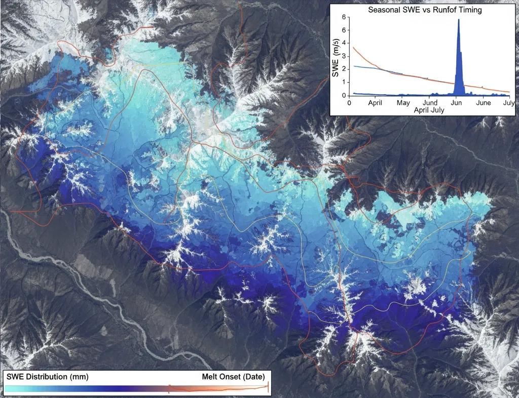
The Water Stored in Snow
In the Himalaya and Western Himalaya ranges, snow isn’t just frozen precipitation, it’s India’s seasonal water bank .
When temperatures rise, this bank liquefies into rivers that sustain irrigation, hydropower, and drinking water for hundreds of millions.
To manage this cycle, we need more than snow maps, we need snow hydrology , a science built around two core variables:
SWE (Snow Water Equivalent) , how much water the snowpack contains
Runoff timing , when that water will enter rivers
Today, satellites, reanalysis models, and energy-balance algorithms give India a clearer-than-ever view of how snow feeds our river basins.
Why SWE Matters More Than Snow Area
A slope covered by 10 cm of snow is very different from one holding 80 cm, even if satellite images show both as “white.”
That’s why Snow Water Equivalent (SWE) is the true hydrological metric.
SWE represents the depth of water stored in the snowpack if it were melted.
SWE = ρ(snow) × H
Where = snow depth and ρ(snow) = snow density.
With SWE maps, we can:
Estimate seasonal water availability
Predict runoff peaks
Plan hydropower scheduling
Issue flood advisories for rapid melt
How We Estimate SWE from Space
Unlike snow extent (easy to detect through reflectance), SWE needs penetration , seeing through the snowpack.
So, we combine multiple sensors:
1️⃣ Microwave Sensors (Passive & Active)
Microwave signals penetrate snow, allowing depth and density estimation.
AMSR2, SMAP: SWE estimation at 10–25 km
Sentinel-1 SAR: Higher resolution (10 m), great for snow mapping in rugged terrain
Advantages: Works under clouds, critical for winter Himalaya
2️⃣ Optical Sensors
Used for albedo, grain size, and snow cover fraction.
Sentinel-2, MODIS
Essential for melt timing detection
3️⃣ Reanalysis Models
Blend satellite + weather + snowpack physics.
ERA5-Land, GLDAS, SNOWPACK, VIC
Provide consistent SWE time series
Fusion models (optical + microwave + reanalysis) now offer SWE at 500 m–5 km resolution across the Himalaya, a massive leap for India’s water forecasting.
Snowmelt Runoff: The Timing That Governs Rivers
Snow is a storage system, but runoff timing dictates when that stored water becomes river flow.
Runoff is governed by:
Temperature rise
Solar radiation
Albedo decline
Snow grain metamorphism
Wind + humidity
Terrain aspect and slope
Geospatial hydrology transforms these variables into degree-day or energy-balance melt models .
Runoff timing insights:
South-facing slopes melt 2–3 weeks earlier
Dust deposition accelerates melt by lowering albedo
Spring heatwaves can shift peak runoff by 10–20 days
Rain-on-snow events create flash-flood-like pulses
These patterns are essential for predicting pre-monsoon flows in the Indus, Chenab, Beas, and Sutlej basins.
India’s Snow Hydrology Monitoring Systems
India uses a multi-layered network to estimate SWE and melt dynamics:
NRSC Snow & Glacier Monitoring: MODIS-derived snow cover + SWE estimates
SASE (DRDO): Snowpack stations + avalanche forecasting
IMD: Temperature, rainfall, and radiation for melt models
NIH Roorkee: Basin-scale snowmelt runoff modeling
Sutlej–Chenab hydropower operators: Reservoir rule-curve optimization fed by SWE forecasts
Together, they support operational hydrology for HEP projects (NHPC, SJVN) and state irrigation departments .
Case Example: Sutlej Basin Snowmelt Forecasting
A 2022 study combining Sentinel-1 SAR, AMSR2 SWE, and ERA5-Land temperature mapped SWE and melt timing for the Sutlej basin. Findings:
Peak SWE: February–March
Melt onset: Mid-April in south-facing slopes
Peak runoff: Late May to mid-June
Snowmelt contributed 35–45% of pre-monsoon river discharge
This modeling improved reservoir inflow forecasts by ~18% , enabling better hydropower scheduling.
GeoAI for SWE and Melt Prediction
AI models are increasingly used to refine SWE and forecast snowmelt:
LSTM Models: Predict melt progression using temperature + radiation + SWE
CNNs: Fuse SAR + optical features for finer SWE mapping
Hybrid AI–physics models: Use ML to correct biases in physical snow models
Random Forest: Classify snow vs. ice vs. debris-covered zones
This reduces uncertainty in highly variable Himalayan snowpacks.
Basin Digital Twins: The Future of Snow Hydrology
A Snow Hydrology Digital Twin integrates:
SWE rasters
Snow extent + albedo
Temperature and radiation forecasts
Melt runoff models
Reservoir and river flow data
Real-time weather from AWS stations
Such twins provide:
Daily SWE updates
7–30 day runoff forecasts
Climate scenario melt simulations
Early warnings for snowmelt-driven floods
This is the future of Himalayan water governance, dynamic, data-driven, and predictive.
Conclusion
Snow isn’t just a winter phenomenon, it’s a hydrological engine.
Through SWE and melt-timing analytics, satellites now reveal when India’s mountain water reserves will flow downstream and how climate change is altering that rhythm.
In a warming world, snow hydrology is becoming one of India’s most critical climate intelligence pillars.