Many Digital Twin projects do not fail because of poor dashboards or weak models.
They fail because the wrong data is captured in the first place.
Introduction
In Phase 1 of this series, I focused on clarifying what a Digital Twin is, where it fails, and why foundations matter.
Now in Phase 2: Architecture & Technology Stack , the focus is shifting to a more practical question:
👉 How are these systems actually built?
And one of the most important layers is the sensor layer .
This is where the Digital Twin begins to connect with reality.
But this is also where many organizations make costly mistakes:
choosing technology based on trends
deploying too many sensors
collecting data they do not need
or missing the right data altogether
The real question is not: 👉 What technology is available?
It is: 👉 What kind of reality are we trying to capture—and how often?
The Core Idea: Not All Sensing Technologies Solve the Same Problem
A Digital Twin needs inputs from the physical world.
But “physical world data” is not one category.
Different technologies capture different dimensions of reality:
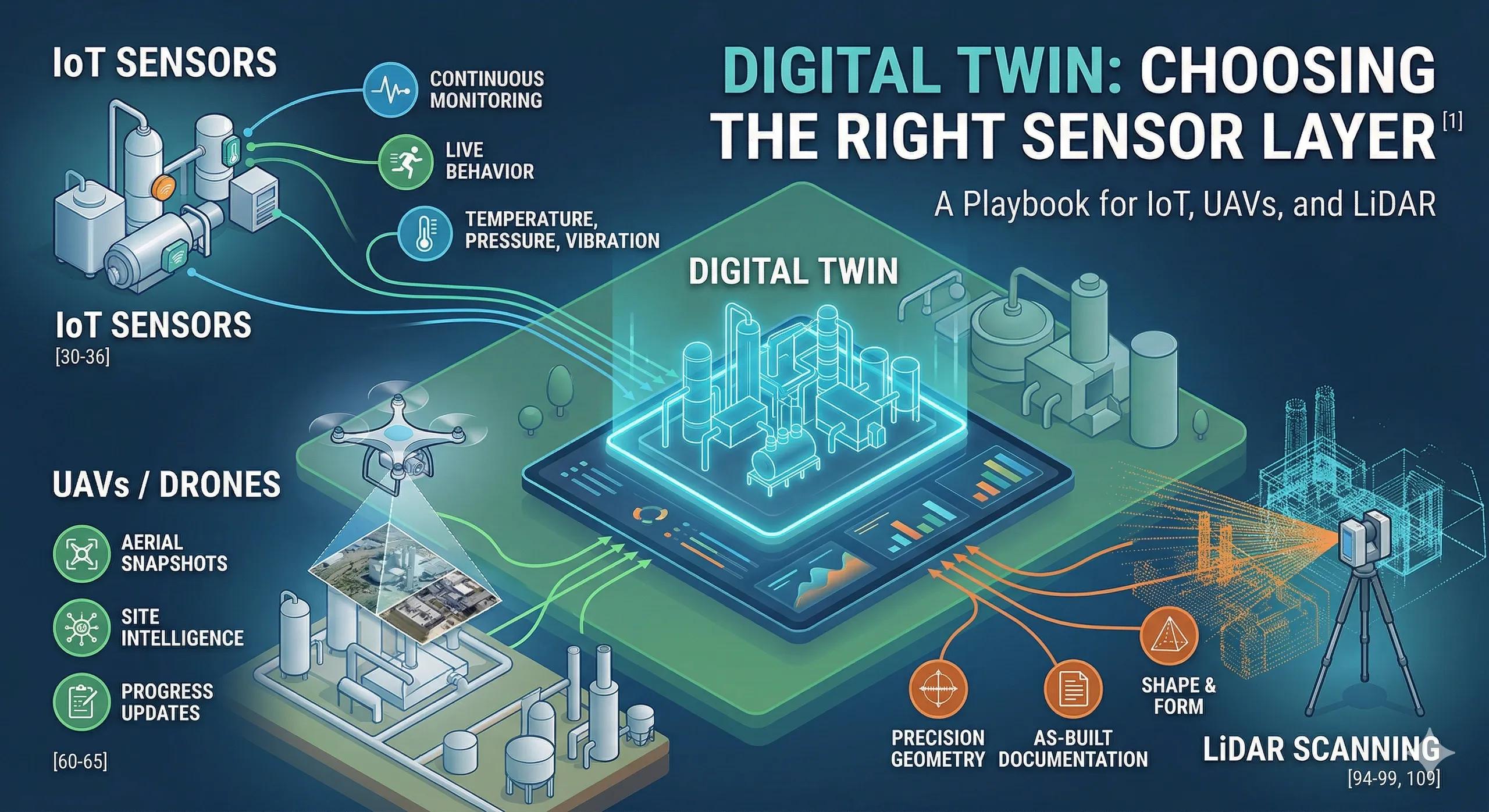
IoT captures ongoing behavior
UAVs capture site-scale visual and spatial updates
LiDAR captures high-precision geometry
This means the right choice depends on:
what you need to measure
how frequently you need updates
what level of accuracy is required
how the data will be used in decisions
1. IoT: Best for Continuous Monitoring
IoT sensors are designed to capture live operational conditions .
They are useful when the Digital Twin needs to understand:
temperature
pressure
vibration
flow
occupancy
humidity
equipment status
energy consumption
Use IoT when:
conditions change frequently
decisions depend on current state
alerts or automation are required
you need trend monitoring over time
Typical use cases:
predictive maintenance in manufacturing
HVAC and energy monitoring in buildings
water pressure monitoring in utilities
traffic flow monitoring in transport systems
Strengths:
continuous or near real-time data
supports alerts and automation
useful for operational decision-making
Limitations:
depends on connectivity and power
requires calibration and maintenance
often provides point-level data, not full spatial context
👉 IoT is best when you need the pulse of the asset .
2. UAVs: Best for Flexible Site Intelligence
UAVs or drones are useful when you need to capture:
aerial imagery
orthomosaics
progress updates
site conditions
volumetric changes
hard-to-reach areas
They are especially valuable in environments where:
manual inspections are slow
site coverage is large
periodic updates are enough
visual and spatial information matters
Use UAVs when:
you need rapid site-wide assessment
terrain or site conditions change periodically
you need inspection without disrupting operations
you want visual evidence for planning or validation
Typical use cases:
corridor and highway monitoring
mine progress and stockpile analysis
construction progress tracking
roof, tower, and utility inspections
disaster assessment
Strengths:
fast coverage of large areas
rich visual and geospatial data
flexible deployment
lower field effort for repetitive inspections
Limitations:
not continuous like IoT
weather and regulatory limitations apply
depends on flight planning and post-processing quality
👉 UAVs are best when you need a fast spatial snapshot of changing ground reality .
3. LiDAR: Best for Precision Geometry
LiDAR is used when geometry matters at a much higher level of precision.
It helps capture:
terrain
asset shape
structural dimensions
elevation variation
complex environments in 3D
This is essential when the Digital Twin must represent the physical asset with high spatial fidelity.
Use LiDAR when:
geometry accuracy is critical
the environment is complex
elevation and structure matter
you need high-quality 3D capture
Typical use cases:
as-built documentation
plant and factory scanning
rail and highway corridor mapping
bridge and infrastructure capture
flood modeling using terrain precision
Strengths:
highly accurate 3D spatial data
strong for terrain and structural modeling
valuable for BIM updates and geospatial alignment
Limitations:
higher cost than standard imagery
large data volumes
requires specialist processing and interpretation
👉 LiDAR is best when you need the shape and form of reality with precision .
What Each Technology Actually Captures
A simple way to understand the difference:
IoT tells you what is happening
UAVs show you what has changed across the site
LiDAR tells you what the environment physically looks like in detail
That is why these technologies should not be treated as alternatives in every case.
In many strong Digital Twin systems, they work together.
Practical Example
Scenario: Industrial Facility Digital Twin
A company wants to build a Digital Twin for a processing facility.
IoT is used for vibration, temperature, and machine status
UAVs are used for periodic external inspection of tanks, roofs, and yard conditions
LiDAR is used to create an accurate 3D as-built model of the plant
Now each technology serves a different layer of understanding:
IoT = live operational behavior
UAV = periodic visual/site intelligence
LiDAR = precision spatial baseline
👉 Together, they create a more complete and usable Digital Twin.
Where Most Organizations Go Wrong
1. Choosing Based on Hype
Deploying drones or IoT because they are trendy, not because the use case demands them.
2. Expecting One Technology to Do Everything
Trying to use UAV imagery for what needs LiDAR precision, or IoT for what needs spatial inspection.
3. Over-Instrumentation
Installing too many sensors without defining what decisions they support.
4. Ignoring Operational Constraints
Not accounting for battery life, connectivity, regulations, maintenance, or data processing needs.
5. Capturing Data Without a Decision Path
Collecting data that never enters a workflow, alert system, or planning process.
Ask Yourself
Are you selecting sensing technologies based on what is available or based on what decisions your Digital Twin needs to support?
How to Choose the Right Technology
A practical approach:
Use IoT when:
you need continuous monitoring
conditions change frequently
action depends on live data
Use UAVs when:
you need flexible site-wide updates
visual inspection matters
periodic capture is enough
Use LiDAR when:
precision geometry matters
terrain or structure must be modeled accurately
the as-built condition is critical
Use a combination when:
you need both geometry and behavior
the system must operate across design, operations, and maintenance
one sensor type alone cannot answer the decision problem
Indian Context
In India, this choice matters even more because project conditions vary widely:
smart infrastructure projects need live asset monitoring
industrial sites need accurate as-built capture
highways, rail, and utilities benefit from corridor-scale UAV and LiDAR workflows
urban systems increasingly need a combination of operational sensing and geospatial intelligence
The opportunity is not just to deploy sensors but to build the right sensing strategy for the asset, context, and budget.
Benefits of Choosing the Right Sensor Layer
lower implementation waste
better data relevance
stronger decision support
more scalable architecture
improved ROI from the Digital Twin
Conclusion
The sensor layer is not just about collecting data.
It is about deciding:
what reality needs to be captured
at what frequency
with what level of precision
for which decisions
IoT, UAVs, and LiDAR each play a different role.
The real value comes not from using all of them by default, but from using the right one at the right time for the right purpose .
That is how Digital Twin starts with the right connection to the physical world.