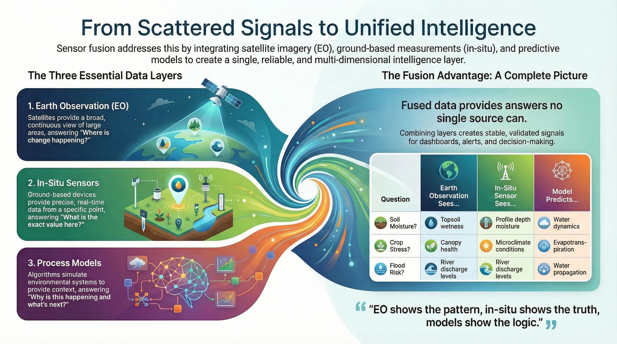
What if every environmental variable, soil, water, crop, weather, carbon, could be measured not from a single source, but from a synchronized network of sensors working together?
This is the promise of sensor fusion at scale .
Earth Observation (EO) provides wide , in-situ sensors provide ground truth , and models provide process intelligence .
Individually, these layers are incomplete.
Together, they form a continuous, multi-resolution, validated signal that powers digital twins, climate analytics, agriculture advisories, hydrology, and urban systems.
Sensor fusion transforms fragmented data streams into operational intelligence .
1️⃣ Why Sensor Fusion Is Necessary
No single sensor can answer modern questions:
Soil moisture? EO sees topsoil, IoT sees profile, models see the dynamics.
Crop stress? EO sees canopy, IoT sees microclimate, models see ET.
Flood risk? EO sees inundation, gauges see discharge, models simulate propagation.
Carbon change? EO sees biomass, soil samples see SOC, models see long-term flux.
Sensor fusion becomes essential because every system (agriculture, hydrology, carbon, climate) is multi-dimensional , and no one sensor captures all dimensions.
2️⃣ Fusion Layer 1, Earth Observation (EO)
EO provides spatial continuity across large regions.
Optical Sensors (Sentinel-2, Landsat, Planet):
vegetation indices
phenology
bare soil mapping
turbidity
evapotranspiration proxies
land-use change
SAR Sensors (Sentinel-1, RISAT):
soil moisture
canopy structure
inundation under clouds
roughness
tillage detection
Thermal Sensors (ECOSTRESS, Landsat TIRS):
canopy temperature
water stress
heat anomalies
EO answers: “ Where is change happening, and how quickly? ”
3️⃣ Fusion Layer 2, In-Situ Sensors
In-situ brings precision and depth .
Types include:
soil moisture probes
weather stations
runoff gauges
water-level sensors
microclimate pods
leaf wetness, canopy temp
groundwater piezometers
In-situ answers: “ What is the exact value here, right now? ”
Given EO’s indirect measurements, in-situ is essential for calibration, bias correction, and validation.
4️⃣ Fusion Layer 3, Process Models
Models provide causal explanations and forward predictions.
Agronomy Models
DSSAT
WOFOST
AquaCrop
Hydrology Models
HEC-RAS/2D
SWAT
VIC
Carbon & Soil Models
RothC
CENTURY
DNDC
Models answer: “ Why is this happening, and what will happen next?”
When fed with EO and IoT inputs, model outputs become dynamic and real-time .
5️⃣ The Sensor Fusion Pipeline (How It Works)
A scalable pipeline consists of five layers :
1. Harmonization
resampling optical + SAR
temporal alignment
cloud masking
normalization across sensors
2. Feature Extraction
EO → NDVI, NDRE, SAR VH/VV, thermal anomalies
IoT → moisture profiles, canopy temp, wind, rainfall
Models → LAI, ET, discharge, biomass, SOC
3. Fusion Algorithms
Bayesian data fusion
Random Forest + XGBoost hybrid models
Kalman filtering (state estimation)
Deep learning (LSTM, CNN, transformers)
Ensemble blending
This produces stable, noise-free, validated signals .
4. Calibration & Validation
In-situ data calibrates EO + model estimates.
This is the backbone of reliable digital twins.
5. Operational Outputs
moisture maps
crop stage predictions
flood nowcasts
vegetation stress alerts
carbon accumulation trends
groundwater recharge estimates
Fusion outputs feed dashboards, advisories, and decision engines .
6️⃣ Use Cases Across Sectors
A. Agriculture
moisture fusion → irrigation advisories
canopy + microclimate → stress detection
biomass + weather → yield forecasting
SOC + NDVI → carbon MRV signals
B. Water Resources
SAR + gauges → reservoir inflow
rainfall + runoff models → flood modeling
soil moisture + weather → drought monitoring
C. Urban Systems
heat data + IoT → micro-heat islands
air quality sensors + satellite AOD → AQI fusion
drainage sensors + DEM → flood response
D. Climate MRV
biomass + LiDAR + field plots → carbon flux
soil sensors + SOC models → soil carbon tracking
Fusion becomes the core foundation of multi-sector digital twins.
7️⃣ India: Scaling Sensor Fusion Is a Strategic Need
India’s scale and diversity demand sensor fusion because:
monsoon clouds block optical EO
fragmented farms require high resolution
risk exposure differs by micro-region
weather variability makes single-source data unreliable
most programs (FPOs, PMKSY, IWMP, DADM) need fused intelligence
Fusion enables:
district-level irrigation advisories
state-level crop forecasting
real-time flood alerts
carbon MRV
precision agriculture
yield modeling
disaster response twins
India’s digital agriculture and climate missions will depend on scalable fusion pipelines .
8️⃣ Sensor Fusion Digital Twins
A fusion-powered digital twin contains:
EO (optical + SAR + thermal)
IoT streams
weather grids
crop + hydrology + soil models
calibration loops
uncertainty quantification
simulation engines
This is far more than a dashboard, it is a living computational object that learns from every sensor.
Conclusion
Sensor fusion is not the future of geospatial intelligence, it is the operational layer that makes every modern system reliable.
EO shows the pattern , in-situ shows the truth , models show the logic .
When fused, they allow us to measure, predict, and manage Earth systems with unprecedented accuracy.
We move from scattered signals → unified intelligence.