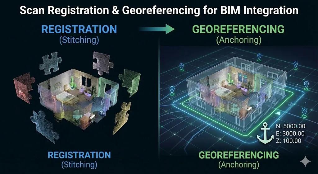
Reality capture only becomes valuable for BIM-to-field workflows when scans are registered correctly and anchored to the right coordinates . Poor registration creates local precision but global confusion. Poor georeferencing creates visually aligned data that fails when measured.
Many teams conflate the two.
Registration aligns scans to each other.
Georeferencing aligns the entire dataset to the project’s Coordinate Reference System (CRS).
Both are required for BIM integration. Missing either one undermines trust in the data and breaks downstream workflows like deviation analysis, layout checks, machine control, and digital twins.
This article explains how scan registration and georeferencing work, where errors commonly occur, and how to ensure scan data integrates reliably with BIM.
1. Why Registration and Georeferencing Are Often Misunderstood
A common misconception:
“The scans line up perfectly, so they must be correct.”
In reality:
Scans can be perfectly registered to each other and still be meters off from BIM
Cloud-to-cloud alignment can look flawless but drift globally
Visual overlap hides cumulative error
Field teams only discover the issue when:
Measurements don’t match
Layout points don’t land correctly
BIM deviations look inconsistent
Registration ensures internal consistency .
Georeferencing ensures external truth .
2. Scan Registration: Making Multiple Scans One Dataset
Registration combines multiple scan positions into a single point cloud.
Common Registration Methods
Target-Based Registration
Uses surveyed targets or spheres
High reliability
Strong global consistency
Slower setup
Cloud-to-Cloud Registration
Uses geometry overlap
Faster capture
Sensitive to geometry quality
Risk of drift over large areas
Best practice on construction sites is hybrid registration :
Targets establish control
Cloud-to-cloud improves local fit
3. Registration Quality Metrics That Matter
Registration is not “done” until it is measured.
Key indicators:
Registration error (RMS)
Overlap percentage
Distribution of residuals
Consistency across scan loops
Low average error with localized spikes is a warning sign.
4. Georeferencing: Anchoring Reality to Project Coordinates
Georeferencing ties the registered scan to:
Project CRS
Survey control
Vertical datum
This step enables:
BIM alignment
Multi-epoch comparison
Integration with UAV and GIS data
Without georeferencing:
BIM comparison becomes guesswork
Deviations are unreliable
Digital twins fail
5. Common Georeferencing Approaches
Survey Control-Based
Uses known control points
Highest confidence
Preferred for construction
GNSS-Based
Useful outdoors
Limited indoors
Requires validation
Manual Alignment
Visual matching
High risk
Never suitable for measurement
If measurements matter, manual alignment is unacceptable .
6. Vertical Datum: The Silent Failure Point
Many alignment issues stem from vertical mismatch.
Common causes:
Different datums (MSL vs local)
Incorrect geoid model
Inconsistent elevation references
Vertical errors are harder to spot visually but devastating for:
Slab flatness checks
Drainage
Equipment alignment
Vertical datum must be explicitly defined and verified.
7. Registration Drift: How It Happens
Drift occurs when:
Large areas lack geometry
Repetitive geometry dominates
Control points are sparse
Scans are chained without loops
Symptoms include:
Increasing error away from control
Misalignment at extremes
Inconsistent deviation results
Drift is prevented through planning , not post-processing.
8. Validating Alignment Before BIM Integration
Before bringing scans into BIM tools, confirm:
✔ Control points match surveyed coordinates
✔ Checkpoint errors are within tolerance
✔ Vertical alignment verified
✔ No visible warping across zones
✔ Measurements are repeatable
If validation fails, BIM integration must stop.
9. Registration & Georeferencing in Multi-Epoch Scanning
For progress tracking:
Each scan must align to the same CRS
Registration consistency across epochs is critical
Drift compounds over time
Multi-epoch misalignment produces false progress signals.
10. Why This Matters for BIM-to-Field Execution
When registration and georeferencing are correct:
Deviations are defensible
Layout checks are reliable
Field teams trust the data
Reality capture becomes decision-grade
When they are wrong:
Arguments replace analysis
BIM credibility drops
Scans get ignored
Conclusion
Registration and georeferencing are not technical formalities.
They are the foundation of trust in BIM-integrated reality capture.
Registration answers:
Do all scans agree with each other?
Georeferencing answers:
Do scans agree with the real world?
BIM-to-field workflows require both .
Without them, reality capture becomes a visual artifact.
With them, it becomes construction intelligence .