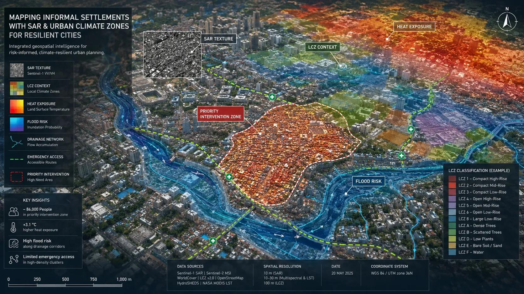
The Planning Blind Spot in Fast-Growing Cities
Informal settlements are often discussed as a housing issue.
But for resilient cities, they are also a data issue.
Many of the most vulnerable parts of a city are also the least visible in formal urban records. They may not appear clearly in cadastral databases. They may be missing from utility maps. They may be poorly represented in infrastructure plans. In fast-growing cities, they can expand, densify, and transform faster than official systems can update.
That creates a serious planning gap.
When a heatwave hits, who is most exposed?
When flooding occurs, which communities are most at risk?
When drainage, sanitation, road access, emergency response, or energy access must be prioritized, where should the city act first?
These questions cannot be answered only through broad administrative boundaries. They need a more detailed understanding of actual urban form.
This is where informal-settlement mapping becomes important.
And more importantly, this is where the combination of SAR and Local Climate Zones begins to matter.
Why Optical Imagery Alone Is Not Enough
Most urban mapping workflows still depend heavily on optical satellite imagery.
Optical imagery is powerful. It is intuitive. It helps us see roofs, roads, open spaces, vegetation, and visible land-use patterns.
But optical data has limits.
Cloud cover can interrupt observation. Seasonal changes can alter what the model sees. Similar-looking urban areas can be confused. A formal compact low-rise neighborhood and an informal dense settlement may look spectrally similar in some imagery, even though their planning realities are very different.
This matters because informal settlements are not defined only by rooftops.
They are shaped by density, material quality, street structure, drainage access, open-space scarcity, service gaps, thermal exposure, and social vulnerability. Many of these signals are not easy to capture from optical imagery alone.
Why SAR Matters for Informal-Settlement Mapping
Synthetic Aperture Radar, or SAR, deserves more attention in urban resilience work.
SAR does not “see” the city in the same way optical sensors do. It captures structural and surface characteristics using radar signals. This makes it useful in situations where cloud cover, poor lighting, or visual similarity reduce the value of optical imagery.
For cities in tropical, monsoon, coastal, and fast-growing regions, that is not a minor advantage. It is operationally important.
When mapping vulnerable settlements, SAR texture can help reveal patterns of built-form disorder, density, and structural variation. These are the kinds of signals that often separate informal areas from planned compact neighborhoods.
This does not mean SAR replaces optical imagery.
It means SAR adds another layer of evidence.
That is an important shift.
Resilient cities cannot be planned from a single image layer. They need multi-sensor intelligence. Optical imagery shows visible surface patterns. SAR adds structural information. Elevation data adds terrain and flood context. IoT adds live environmental signals. Ground surveys add social and infrastructure reality. Together, these layers create a more reliable urban picture.
Why Urban Climate Zones Add Critical Context
Sensing alone is still not enough.
We also need urban context.
This is where Local Climate Zones, or LCZs, become valuable.
LCZs classify urban and natural landscapes based on physical characteristics such as building density, building height, surface cover, vegetation, and thermal behavior. Instead of treating a city as one uniform built-up area, LCZs help us understand the city as a set of climate-relevant urban forms.
That distinction is critical.
A dense informal settlement, a compact low-rise formal neighborhood, an industrial zone, a high-rise residential area, and an open low-density suburb may all sit within the same city boundary. But they do not experience heat, flooding, ventilation, drainage stress, or infrastructure pressure in the same way.
For climate resilience, the type of urban form matters.
For public health, the type of urban form matters.
For disaster response, the type of urban form matters.
For infrastructure investment, the type of urban form matters.
When informal-settlement mapping is connected with LCZ logic, the output becomes more than a map of “where settlements exist.” It becomes a way to understand which urban zones may carry higher exposure, lower adaptive capacity, and greater operational risk.
The Better Question for Resilient Cities
This changes the planning conversation.
The question is no longer only:
“Where are the informal settlements?”
The better question is:
“Which vulnerable urban zones face the highest combined risk from heat, flooding, poor access, weak infrastructure, and rapid densification?”
That is the level of intelligence cities need.
Because resilient cities are not built only by creating smart dashboards. They are built by directing limited resources to the right locations, at the right time, with the right evidence.
Practical Use Cases for City Planning
If a city wants to plan heat mitigation, informal-settlement maps can be overlaid with LCZs, land surface temperature, tree cover, roof material proxies, and population density.
If a city wants to improve flood preparedness, settlement boundaries can be combined with drainage networks, slope, elevation, rainfall intensity, historical flood extents, and road accessibility.
If a city wants to upgrade services, these maps can support prioritization for water, sanitation, street lighting, emergency access, waste collection, and public health outreach.
If a city wants to monitor change, multi-temporal satellite data can show where densification is increasing, where expansion is occurring, and where risk is accumulating.
This is where geospatial intelligence becomes a governance tool.
Not just a mapping exercise.
Why This Matters for India and Other Rapidly Urbanizing Regions
For India, Africa, Southeast Asia, and many other rapidly urbanizing regions, this is especially relevant.
Many cities are expanding faster than their formal planning systems can track. Informal growth often happens in environmentally sensitive or infrastructure-poor locations: near drains, along transport corridors, on flood-prone land, beside industrial areas, or on urban edges where public services lag behind settlement growth.
Ignoring these areas does not make them disappear.
It only makes the risk harder to manage.
A resilient city must be able to see all its people, all its built forms, and all its vulnerabilities.
The Urban Data Stack Cities Need
This requires a different urban data stack.
At minimum, cities need:
Regular satellite-based settlement monitoring
SAR and optical fusion for more reliable mapping
Local Climate Zone classification for urban climate context
Flood, heat, drainage, and infrastructure overlays
Ground validation and community-level feedback
A digital twin or geospatial platform that turns these layers into decisions
The last point is important.
A map is useful only when it changes action.
If informal-settlement mapping remains a static GIS layer, its value is limited. But if it feeds into a city digital twin, planning dashboard, disaster command center, or climate-risk platform, it becomes operational intelligence.
It can support ward-level resilience planning.
It can guide infrastructure upgrades.
It can improve emergency response.
It can help cities prioritize communities that are exposed but underrepresented in formal data.
From Smart-City Dashboards to Decision-Ready Urban Intelligence
This is the real promise of SAR and LCZ-based informal-settlement mapping.
It helps move urban resilience from general awareness to targeted action.
It also reminds us of a broader truth about smart cities.
A city is not smart because it has sensors, dashboards, or 3D models.
A city becomes smarter when its data systems help it see reality more clearly, especially where reality is complex, informal, and underserved.
The future of urban resilience will not be built only around high-rise districts, planned corridors, and premium infrastructure zones.
It must also include the settlements that are often missing from official records but deeply exposed to climate and infrastructure risk.
What This Means for Geospatial Teams
For geospatial teams, this is a major opportunity.
For city governments, it is a planning necessity.
For technology providers, it is a reminder that responsible GeoAI must focus not only on automation, but also on inclusion, reliability, and decision readiness.
The next generation of resilient-city platforms should not simply answer:
“What is built?”
They should answer:
“Who is exposed, what is changing, where is risk growing, and what should the city do next?”
That is where informal-settlement mapping, SAR, and Local Climate Zones begin to come together.
And that is where spatial intelligence becomes a foundation for more resilient, more equitable cities.