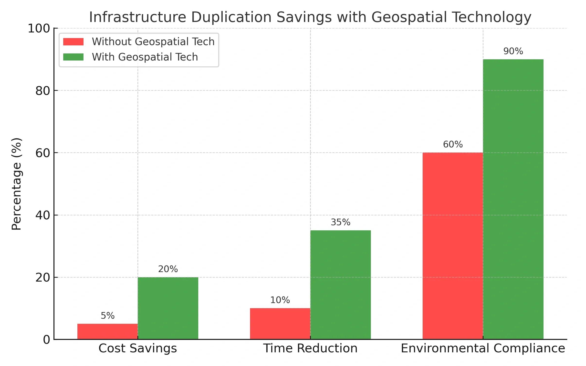
India’s Gati Shakti National Master Plan (NMP) is an ambitious initiative designed to break silos between ministries, speed up project execution, and ensure smarter infrastructure investments. With a projected $1.4 trillion infrastructure pipeline, the plan’s success depends on accurate, interoperable, and real-time spatial data, this is where geospatial technology steps in.
From satellite imagery to 3D mapping, geospatial tools create a single source of truth for roads, railways, ports, and power lines. In a country as vast and diverse as India, the ability to see everything on a map before breaking ground is a game-changer.
1. The Gati Shakti Vision and Challenges
The Gati Shakti NMP aims to integrate infrastructure planning and execution across 16 ministries. It targets:
Eliminating duplication of assets (e.g., multiple agencies unknowingly building parallel roads)
Optimizing logistics routes to reduce cost and travel time
Prioritizing investments based on real-time needs
Challenges without geospatial intelligence:
Data silos between ministries lead to poor coordination
Static planning models fail to account for dynamic socio-economic changes
High project delays due to unclear land acquisition and environmental mapping
2. How Geospatial Technology Fits In
Geospatial technology acts as the digital nervous system for Gati Shakti.
Core components include:
Satellite Remote Sensing: High-resolution imagery for land-use classification
GIS Databases: Layering transport, utilities, population, and environmental data
LiDAR & Drone Surveys: Generating precise terrain models for engineering designs
Digital Twins: Simulating entire corridors for scenario-based decision making
Example: When planning a new freight corridor, geospatial mapping can:
Avoid flood-prone areas identified via hydrological models
Ensure alignment with existing industrial hubs
Minimize displacement in high-density settlements
3. Spatial Mapping in Action, A Step-by-Step Use Case
Scenario: Planning a multi-modal logistics park in eastern India.
Base Map Creation: Combine satellite imagery and Survey of India maps Geocode existing transport links and land parcels
Layer Integration: Overlay population density to assess workforce proximity Add industrial cluster maps to align with economic zones
Feasibility Analysis: Simulate freight flow scenarios with AI traffic models Run environmental impact checks
Execution Monitoring: Real-time IoT sensor feeds from ongoing projects Track delays and send alerts through a centralized dashboard
4. Benefits to India’s Infrastructure Push
Direct Impacts:
Cost Optimization: Reduced redundant infrastructure spending
Speed: Faster project approvals with pre-vetted geospatial data
Risk Reduction: Avoidance of environmental and legal disputes
Broader Economic Benefits:
Boost in Logistics Efficiency: Target of reducing logistics cost from 14% to 8% of GDP
Rural-Urban Connectivity: Better market access for farmers
Sustainability: Lower carbon footprint through optimized routing
5. Future Directions , Where India Can Lead
Integration with AI: Predictive modeling for demand-based infrastructure scaling
Blockchain for Land Records: Transparent and tamper-proof data for faster clearances
Crowdsourced Data Layers: Community-driven updates on ground realities
Real-time Digital Twins: Monitoring infrastructure health continuously
💡 If you had access to a nationwide real-time infrastructure map, which sector would you prioritize first, transport, energy, or water?
Conclusion
Geospatial technology isn’t just a support tool for the Gati Shakti Master Plan, it’s the foundation for turning ambitious infrastructure blueprints into reality. With India’s rapid urbanization and economic growth, every misplaced bridge or redundant rail line costs more than just money, it costs opportunity.
By integrating spatial intelligence into every stage of planning and execution, India can move from reactive infrastructure building to strategic, data-driven development.