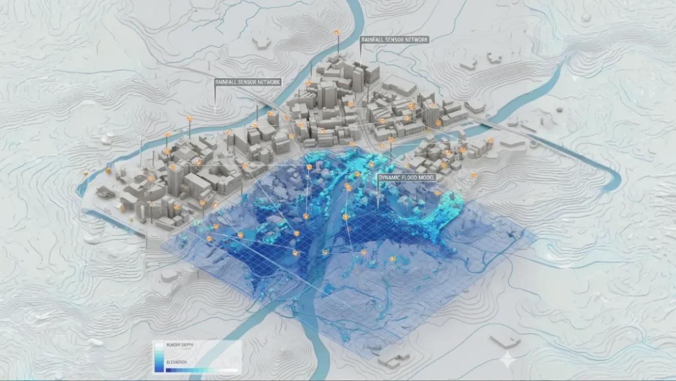
When Every Drop Becomes Data
Rainfall is chaotic. It doesn’t fall evenly, flow uniformly, or behave predictably, yet it follows patterns we can now measure and model in real time.
By combining IoT rainfall sensors , hydrological models , and 2D hydraulic simulations , engineers are creating Rain–Runoff Digital Twins , dynamic replicas of how precipitation translates into flow, flood, and impact.
These twins turn what was once static hydrology into a living, data-driven system that continuously learns from rainfall and river behavior.
The Core Logic: From Cloud to Channel
At its heart, a Rain–Runoff Digital Twin integrates three layers:
Rainfall Sensing (Data Ingestion Layer)
Rain gauges, radar, and IoT sensors capture spatially variable rainfall intensity (mm/hr) .
Data streams from IMD, AWS, or citizen sensors feed the system every 5–15 minutes.
Satellite precipitation (e.g., IMERG, GPM) supplements gaps in ground coverage.
Hydrological Response (HEC-HMS / Runoff Models)
The twin uses rainfall-runoff models (e.g., SCS-CN, Green-Ampt) to compute surface flow, infiltration, and excess runoff.
Parameters such as curve number (CN) , time of concentration , and basin lag are dynamically updated based on soil moisture and land use.
Hydraulic Simulation (HEC-RAS 2D / Flow Models)
The generated hydrograph feeds into a HEC-RAS 2D model that simulates how runoff moves through channels and floodplains.
DEMs and LiDAR terrain data define flow paths, and friction coefficients (Manning’s n) simulate surface roughness.
The result: dynamic flood depth and velocity maps that evolve in real time as rain falls.
This loop, sensor → model → twin, creates a continuously updating picture of how rainfall turns into flood risk.
Why Digital Twins Matter for Hydrology
Traditional hydrological models were “run once and done.”
Digital twins, by contrast, are event-driven and self-correcting , they update predictions as new data arrives.
Key advantages:
Real-time forecasting: Near-live inundation maps within 5–10 minutes of sensor input.
What-if simulations: Evaluate drainage upgrades or flood defense measures under changing rainfall patterns.
Calibration on the fly: The model auto-adjusts parameters using real-time sensor feedback.
Visual communication: Stakeholders can see dynamic 3D maps of rainfall, runoff, and inundation evolving frame by frame.
In essence, rain no longer just happens, it gets digitally interpreted .
Building the Twin: The Technical Stack
Layer - Tools & Data - Function
Data Layer - IoT rain gauges, AWS, GPM/IMERG, soil moisture sensors - Real-time rainfall and ground conditions
Model Layer - HEC-HMS, HEC-RAS 2D, SWMM, MIKE FLOOD - Rain-runoff transformation and hydraulic simulation
Integration Layer - Python APIs, GeoServer, ArcGIS ModelBuilder - Data fusion and visualization
Analytics Layer - Dashboards, AI anomaly detection, alert systems - Decision support and early warning
Twin Visualization - Cesium, Unreal Engine, QGIS 3D - Real-time 3D hydrodynamic visualization
By linking rainfall and flow models with IoT data streams, the twin becomes an adaptive hydrological platform , continuously ingesting, computing, and visualizing.
Case Example: Hyderabad Urban Flood Model
In 2023, Hyderabad’s municipal command center deployed a pilot Rain–Runoff Digital Twin for real-time flood monitoring:
30 IoT rain sensors across key drainage zones.
5 m CartoDEM integrated into HEC-RAS 2D.
Hydrographs updated every 10 minutes , with live rainfall overlays.
Real-time dashboards displayed flood depth, flow velocity, and affected road segments .
During heavy monsoon events, forecast accuracy improved by 40% compared to static flood models, allowing early alerts to emergency teams and residents.
This demonstrated how digital twins can transition flood management from response to anticipation.
GeoAI: Learning from Every Rain Event
Machine learning enhances these twins by continuously improving parameter calibration:
Rainfall–Runoff Regression: ML models learn nonlinear relationships between intensity, infiltration, and flow volume.
Error Correction Models: Compare predicted vs. observed flows to recalibrate CN and infiltration rates.
Pattern Detection: AI identifies zones of recurring flood onset for drainage design upgrades.
The longer the twin runs, the smarter it gets, turning rainfall history into predictive intelligence.
Outlook: Toward City-Scale Hydrological Twins
Imagine every stormwater drain, lake, and culvert in a city connected to a shared digital twin.
Rain sensors feed data in, hydraulic models compute flow, and city dashboards display impacts, not as static maps, but as live evolving hydroscapes.
This is the future of urban hydrology:
Continuous monitoring, not seasonal studies.
Model updates driven by sensors, not manual recalibration.
Real-time visualization for immediate decisions.
Cities like Bengaluru, Chennai, and Mumbai are already moving toward this hydrological intelligence infrastructure.
Conclusion
Rain–Runoff Digital Twins mark a new era in water management.
By fusing sensors, physics, and computation, we move beyond mapping flood risk to modeling the hydrology of the moment , where each rainfall pulse reshapes predictions and informs action.
Because in the age of digital twins, every drop counts, and every drop teaches.