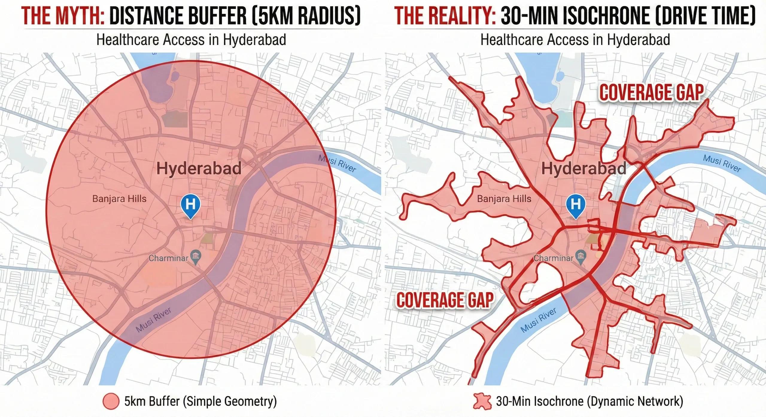
What if we could map health access not by distance, but by time, reachability, and real demand?
Public health is not only about doctors, beds, and medicines.
It is fundamentally about access , who can reach a clinic, how quickly, by what mode, and under what constraints.
For millions, a hospital is not “far,” it is simply unreachable .
Geospatial analytics changes this by mapping clinics as nodes, populations as demand clusters, and travel-time isochrones as the true measure of access.
This is how countries detect health deserts, optimize facility locations, and equitably distribute services.
1️⃣ The Health System Is a Spatial Network
The public health ecosystem is a graph:
Nodes → clinics, PHCs, CHCs, hospitals
Edges → roads, footpaths, transit lines
Demand points → households, urban slums, villages
Barriers → terrain, cost, congestion, weather
For every region, accessibility depends on:
travel time
transport availability
clinic readiness
treatment capacity
population density
vulnerability (age, income, pregnant women)
GIS turns these factors into an actionable map.
2️⃣ Clinics as Network Nodes
Every healthcare facility has three critical attributes:
A. Catchment Population
How many people live within reach?
This identifies overloaded and underused facilities.
B. Capability
PHC vs CHC vs district hospital, each has different medical depth.
C. Readiness
staffing
diagnostics
essential medicines
emergency care
cold chain
A clinic with poor readiness reduces effective accessibility.
3️⃣ Isochrones: The Real Measure of Access (Not Distance)
Distance means little.
Time matters.
Isochrones map travel-time rings around each facility:
10-minute catchment
30-minute catchment
60-minute catchment
Generated using:
road network graphs
elevation & slope data
traffic congestion
public transport schedules
availability of ambulances
These rings classify populations as:
Accessible (<30 min)
At risk (30–60 min)
Health deserts (>60 min)
In rural India, many villages fall into the >60 min zone.
4️⃣ Detecting Gaps in Health Coverage
Accessibility gaps emerge due to:
poor road connectivity
no public transit
steep terrain (especially NE India & Himalaya)
rivers without bridges
sparse population clusters
under-equipped PHCs
seasonal isolation (floods, landslides)
GIS highlights these gap types:
A. Coverage Gaps
Populations with no facility within 30–45 min.
B. Service Gaps
Nearby clinic exists but lacks medical capacity.
C. Network Gaps
Paths exist but travel is too slow for emergencies.
D. Seasonal Gaps
Monsoon/flood months isolate entire blocks.
E. Equity Gaps
Low-income or tribal regions underserved.
These insights guide health investments.
5️⃣ GeoAI for Healthcare Planning
GeoAI enhances public health geospatial analysis using:
Demand Prediction Models
demographics
disease prevalence
mobility patterns
maternal health indicators
climate-seasonal signals
Facility Location Optimization
Algorithms choose optimal spots for:
new clinics
mobile health vans
emergency response hubs
telemedicine reach points
Risk Stratification Models
Combine:
flood risk
heat exposure
AQI
vector-borne disease hotspots
socio-economic vulnerability
Spatiotemporal Disease Mapping
eg., dengue, malaria, COVID, TB
Based on:
mobility
environment
vector conditions
socio-demographics
This makes public health proactive, not reactive.
6️⃣ Integrating Public Health into Digital Twins
A Public Health Digital Twin integrates:
facility data
population grids
mobility patterns
disease surveillance
weather & climate
live hospital occupancy
ambulance routing
pharmaceutical stock
telemedicine nodes
The twin answers:
Who is unreachable?
Which clinic will overload next?
Where will disease outbreaks intensify?
How should ambulances route during floods?
Which settlements need mobile medical units?
This becomes a real-time health operations system .
7️⃣ India: Where the Gaps Are the Deepest
Indian challenges include:
tribal & forest communities
flood-prone basins
Himalayan terrain
urban slums
migrant populations
weak health information systems
Geo-health mapping can transform:
Ayushman Bharat digital health mission
PHC strengthening under PM-ABHIM
State health dashboards
NGO and CSR health outreach
Disease control programs
Geo-health is not an add-on, it is a core layer for India’s Public Health 2.0.
Conclusion
Public health is spatial.
Who gets care, and how fast, depends on geography more than infrastructure.
By using clinics as nodes, isochrones as access lenses, and GeoAI as the operational brain, governments can close decades-old gaps in healthcare equity.
A map can show where clinics are.
Isochrones show where care reaches .
That difference is everything.