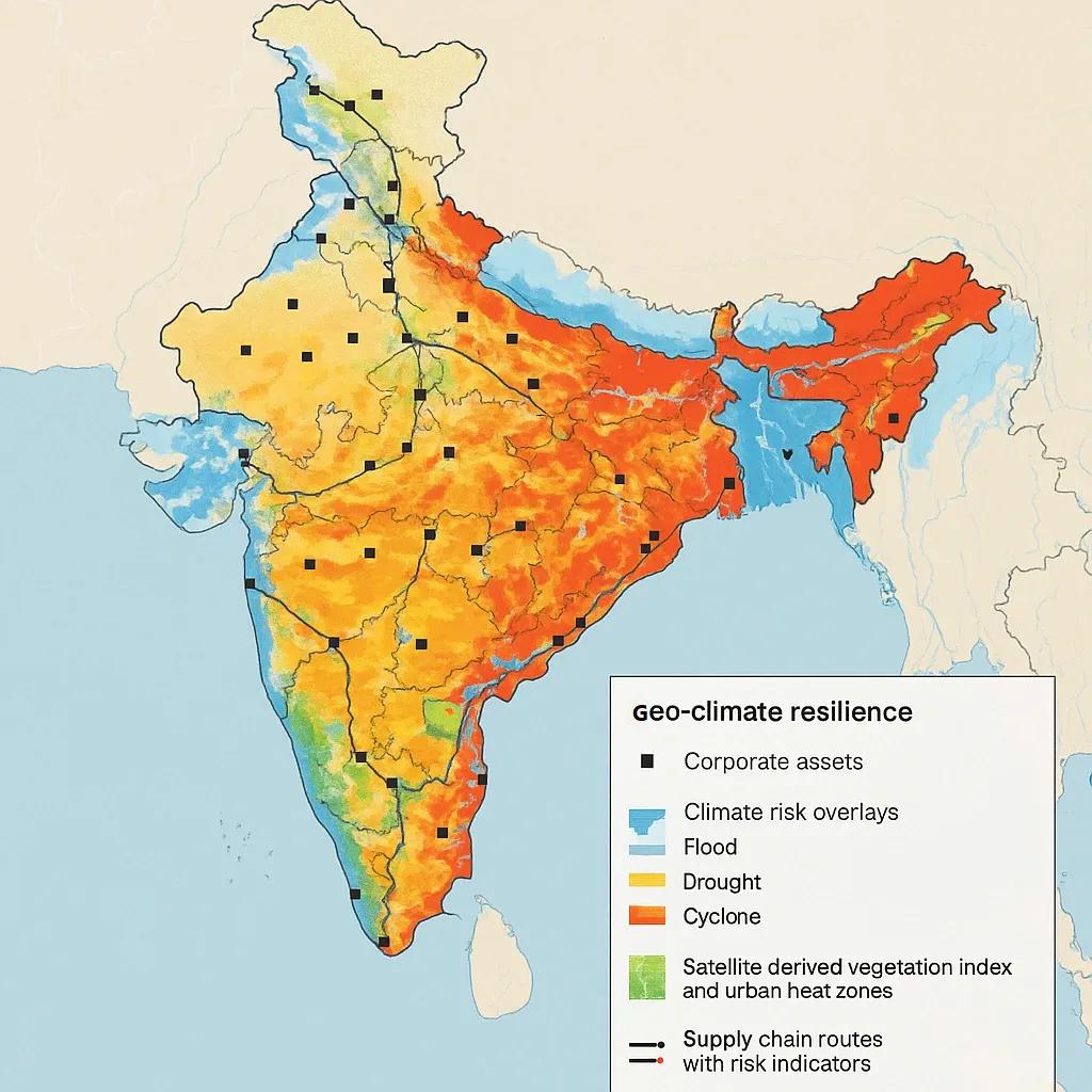
As climate risks intensify across geographies, the private sector is facing mounting operational, financial, and reputational challenges. From supply chain disruptions and asset damages to regulatory scrutiny and investor expectations, climate resilience is no longer a public-sector-only mandate. It is now a strategic business imperative.
Geo-climate resilience, defined as the capacity to anticipate, withstand, and adapt to climate-related hazards using geospatial intelligence, is emerging as a core part of climate risk strategy. Predictive spatial technologies such as satellite analytics, AI-enhanced GIS, digital twins, and climate models allow businesses to move from reactive to proactive risk management.
This article explains the growing importance of geo-climate resilience and outlines why corporates must invest in predictive spatial technologies as a critical asset in future-proofing their operations, supply chains, and ESG commitments.
Climate Risk: A Corporate Exposure
The World Economic Forum (2025) ranks “extreme weather” and “climate action failure” among the top three global risks. For corporates, this translates to:
Disrupted logistics due to floods, storms, or heatwaves.
Asset depreciation in high-risk zones (e.g., coastal infrastructure).
Commodity volatility due to climate impacts on agriculture and water.
Workforce and operational instability from heat stress or disaster displacement.
Increased insurance costs and ESG reporting burdens under climate disclosure norms.
Traditional enterprise risk frameworks, focused on financial volatility and regulatory risk, are not equipped to deal with this level of environmental variability. That’s where predictive spatial technologies come in.
What Is Predictive Spatial Technology?
Predictive spatial technology refers to systems that combine:
Geospatial data (satellite imagery, remote sensing, GPS, etc.)
Climate projections (e.g., IPCC models, CMIP6 datasets)
AI/ML analytics for pattern detection and simulation
GIS platforms for visualization, zonation, and decision-making
These systems help organizations forecast where, when, and how a climate risk may materialize, such as flood risk in urban locations, drought-prone agriculture zones, or wildfire exposure for critical infrastructure. The output is actionable insight, not just maps.
Why Corporates Must Lead, Not Follow
1. Operational Continuity
Companies with spatially distributed assets, like logistics hubs, manufacturing plants, or retail outlets, must understand local climate exposures. Predictive spatial tools can:
Simulate flood risk along delivery corridors
Identify heat stress zones near warehouses
Predict landslide risk along critical utility lines
This supports better site selection, business continuity planning (BCP), and incident response.
2. Supply Chain Resilience
Climate events in one region can ripple across global supply chains. For instance, floods in Thailand previously disrupted semiconductor supply worldwide. Predictive spatial models allow companies to:
Map suppliers in high-risk zones
Simulate climate-driven supply shocks
Diversify sourcing based on geospatial vulnerability scores
Companies like Unilever and Nestlé already use geospatial platforms for climate-aware sourcing decisions.
3. ESG and Climate Disclosure
With increasing pressure from regulators (SEBI in India, SEC in the US, CSRD in Europe), corporates must disclose climate-related financial risks. Predictive spatial tools support:
Physical risk assessments across asset portfolios
Scenario analysis using future climate models
Data-driven disclosures aligned with TCFD/ISSB frameworks
This not only meets compliance but also enhances transparency with investors and insurers.
4. Insurance and Liability Management
Insurers are increasingly adjusting premiums or denying coverage based on asset-level climate risk. Corporates can use spatial insights to:
Pre-emptively mitigate risks (e.g., relocate assets)
Negotiate better premiums with risk intelligence
Reduce post-disaster claims and reputational fallout
In India, companies in sectors like energy, infrastructure, and mining are already being assessed for insurability based on geospatial climate analytics.
5. Strategic Advantage in Green Innovation
By integrating predictive spatial tech, companies can offer:
Climate-resilient infrastructure design in real estate and construction
Smart agri-advisory platforms in agri-business
Disaster mitigation services in insurance and utilities
This creates new revenue streams while aligning with climate adaptation goals.
Examples of Private Sector Use Cases
1. Adani Ports & SEZ
Uses satellite data and geospatial models to monitor coastal erosion and cyclone exposure along its Indian port assets.
2. Tata Steel
Has partnered with climate data providers to assess flood and heat stress risk at its manufacturing plants and mines.
3. Mahindra & Mahindra
Uses GIS-based water stress models to evaluate its rural dealership and service center network, aiding expansion in sustainable regions.
4. Amazon and Microsoft
Have invested in climate mapping APIs and Earth observation datasets to power location-based climate analytics for their cloud customers.
Key Technologies Driving Predictive Spatial Systems
Technology - Function
Satellite Imagery (Sentinel, Landsat) - Real-time monitoring of land use, vegetation, flood zones
Digital Elevation Models (DEM) - Terrain analysis for flood, landslide, and runoff models
Climate Models (CMIP6, CORDEX) - Predictive weather and long-term climate scenario data
AI/ML Algorithms - Pattern recognition, anomaly detection, risk scoring
GIS Dashboards - Spatial visualization and reporting for decision-makers
Cloud platforms like Google Earth Engine, Esri ArcGIS, and Mapbox provide the infrastructure for processing and visualizing spatial climate data at scale.
The Investment Gap
Despite the value, most private sector investment in spatial climate resilience remains low. Barriers include:
Limited internal capacity to interpret spatial data
Unfamiliarity with open-source datasets (e.g., Copernicus, India’s Bhuvan)
Fragmented data pipelines and siloed decision-making
Lack of industry-specific spatial modeling tools
However, Indian startups, global climate tech firms, and public-private platforms (e.g., G-STaR under NRSC) are bridging these gaps.
What Corporates Should Do Now
Conduct Climate Exposure Audits Map current and planned assets with high-resolution spatial data Evaluate risk under different climate scenarios
Invest in Geospatial Skill-Building Train sustainability, operations, and risk teams in geospatial tools Partner with domain experts or startups
Integrate Spatial Tech into ESG Strategy Use GIS models to identify adaptation needs and resilience gaps Align spatial analysis with ESG materiality assessments
Collaborate on Open Standards Join initiatives that develop open data, tools, and resilience benchmarks Engage with state climate missions and national platforms
Conclusion
Climate resilience is not just a compliance checkbox; it is a business continuity and competitiveness issue. The private sector must stop treating spatial technologies as optional and start treating them as strategic.
Corporates that invest in predictive spatial tools will be better positioned to mitigate disruptions, comply with evolving regulations, unlock innovation, and demonstrate long-term value to stakeholders.
The future is uncertain, but the maps are getting sharper. Now is the time for businesses to act, not after the next flood, fire, or failure.