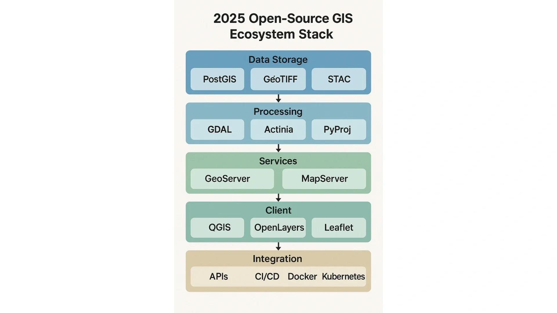
In 2025, open-source GIS (Geographic Information System) tools are no longer just alternatives to proprietary platforms, they are leading innovation in spatial data analysis, geoprocessing, and web-based geospatial applications. Community-driven development, interoperability, and the push for cost-effective digital transformation are accelerating their adoption across sectors such as agriculture, urban planning, disaster management, and infrastructure.
This article explores the most influential open-source GIS tools shaping 2025, organized by core functionalities: desktop GIS, web GIS, spatial databases, geospatial libraries, and cloud-native tools. It highlights the latest features, use cases, and integration strengths of these platforms, reflecting how they are empowering developers, planners, and researchers globally.
1. QGIS: The Flagship Desktop GIS
Overview: QGIS continues to be the most widely adopted open-source desktop GIS. Its 2025 version (QGIS 3.34 and beyond) has evolved into a comprehensive spatial analysis platform supporting both raster and vector operations, advanced symbology, and real-time sensor integration.
Key Features in 2025:
Native support for temporal and 3D data visualization
Tight integration with PostgreSQL/PostGIS, GeoServer, and OGC services
Enhanced support for machine learning plugins (e.g., Scikit-learn, TensorFlow)
QField mobile app for field data collection and offline workflows
Use Cases:
Environmental impact assessment
Urban zoning map generation
Precision agriculture mapping workflows
2. PostGIS: Spatial Engine for PostgreSQL
Overview: PostGIS extends PostgreSQL into a powerful spatial database engine. It remains the backbone for enterprise-scale spatial data infrastructure, supporting millions of transactions per day with geometry and geography types.
What’s New in 2025:
Better indexing for complex geometries using GIST and BRIN hybrids
Support for 3D spatial relationships and voxel data types
Integration with cloud-native architectures via Kubernetes and containerization
Built-in functions for trajectory analysis, topology validation, and spatial clustering
Use Cases:
National land records management systems
Real-time IoT data processing pipelines
Utility network modeling
3. GeoServer and MapServer: OGC-Compliant Web Services
Overview: GeoServer and MapServer are leading open-source tools for serving geospatial data through standard web services (WMS, WFS, WCS). They provide essential backend services for modern web maps and APIs.
GeoServer Highlights (2025):
Support for vector tiles (MVT), COG (Cloud-Optimized GeoTIFF)
Integrated styling via SLD and CSS
WebSocket-based real-time layer updates
Docker and Helm chart availability for cloud deployments
MapServer Enhancements:
Performance improvements for high-demand tile rendering
Native support for OGC API - Features and Tiles (the RESTful successor to WFS/WMS)
Use Cases:
National spatial data infrastructures (NSDIs)
Disaster alerting systems
Custom basemap creation for dashboards
4. OpenLayers and Leaflet: Web Mapping Libraries
Overview: For client-side web mapping, OpenLayers and Leaflet continue to dominate. These JavaScript libraries help developers build highly interactive spatial applications without proprietary SDKs.
OpenLayers 2025 Capabilities:
3D globe visualization using Cesium integration
Native support for GeoPackage and vector tiles
Real-time layer updates from MQTT and WebSocket feeds
Leaflet’s Strengths:
Lightweight performance ideal for mobile and embedded devices
Integration with D3.js and Chart.js for spatial-analytical overlays
Community plugins for routing, clustering, and geofencing
Use Cases:
Real-time logistics tracking
Urban traffic visualization dashboards
Public engagement maps for city planning
5. GDAL/OGR: The Universal Translator
Overview: GDAL (Geospatial Data Abstraction Library) remains a cornerstone for raster and vector data conversion. In 2025, it supports over 250 formats and is optimized for high-performance ETL (Extract, Transform, Load) operations in large spatial datasets.
Recent Developments:
Native support for AWS S3 and Azure Blob Storage
Enhanced streaming for massive remote sensing datasets (Sentinel, Landsat)
Integration with Python, C++, and Rust for faster geoprocessing pipelines
Use Cases:
National-scale raster tiling services
Automated data ingestion workflows for AI models
On-the-fly coordinate system transformations
6. PyProj, Fiona, and Shapely: Pythonic Spatial Libraries
Overview: These Python libraries form the core of most geospatial data science workflows in 2025:
PyProj: Handles projections and coordinate transformations (based on PROJ)
Fiona: Enables reading/writing vector formats using GDAL
Shapely: Provides geometric operations (e.g., intersection, buffer, union)
2025 Trends:
Improved performance using Python 3.12 and multi-threading
Integration with Pandas and GeoPandas for spatial dataframes
Widely used in geospatial AI/ML model pipelines
Use Cases:
Data cleansing and preprocessing for urban mobility datasets
Creating custom spatial analytics scripts in Jupyter notebooks
Automating map production workflows
7. GeoNode and MapStore: GeoCMS and GeoPortal Platforms
Overview: For organizations needing collaborative geospatial content management and publishing, platforms like GeoNode and MapStore offer end-to-end web GIS solutions.
GeoNode 2025 Features:
Drag-and-drop web map creation
Role-based access control for layers and users
OGC-compliant service publishing with analytics dashboards
MapStore Advantages:
ReactJS-based modular interface
Thematic layer styling and spatial querying out of the box
Integration with CKAN for open data portals
Use Cases:
City-level geoportals
Community participatory mapping
Government open data hubs
8. Cloud-Native GIS Tools: Evolving Beyond the Desktop
Emerging Trends in 2025:
TerriaJS: For building spatial data catalogs and 3D globe apps
STAC (SpatioTemporal Asset Catalog): A modern standard for organizing EO datasets, widely used in agriculture and disaster response
Rasdaman: Array database for large-scale time-series and climate data analytics
Actinia: REST API for scalable geoprocessing based on GRASS GIS
Why They Matter: These tools support containerized, serverless, and scalable deployments, enabling organizations to manage petabytes of spatial data efficiently.
Conclusion: Why Open-Source GIS Will Define the Future
Open-source GIS tools in 2025 offer the flexibility, scalability, and innovation edge required for modern geospatial applications. They are foundational to smart cities, digital twins, autonomous systems, and environmental sustainability projects. Community contributions ensure rapid evolution, global accessibility, and localization, especially important for emerging economies and citizen-centric applications.
As industries increasingly rely on geospatial intelligence for decision-making, the open-source ecosystem offers a viable, future-proof pathway. The shift from tool usage to stack orchestration, where tools like QGIS, PostGIS, GeoServer, and OpenLayers work seamlessly together, defines the new era of interoperable and composable geospatial solutions.