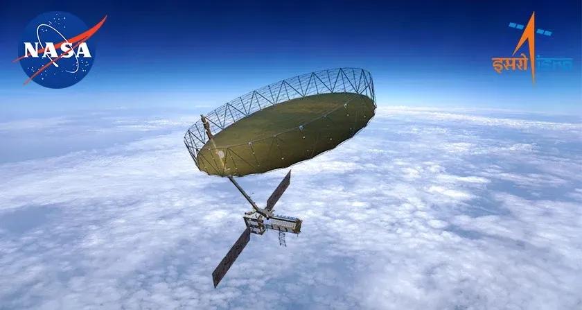
On July 30, 2025, the world witnessed a landmark in space exploration and Earth observation with the successful launch of the NASA-ISRO Synthetic Aperture Radar (NISAR) satellite. Not only is NISAR the costliest Earth observation (EO) satellite ever built , with an estimated price tag exceeding $1.5 billion, but it also sets an extraordinary technical and collaborative benchmark for the entire EO industry. Developed jointly by NASA and ISRO, NISAR brings together two radar systems, L-band and S-band, on a single satellite, enabling breakthrough monitoring and management capabilities for our rapidly changing planet.
This article presents a comprehensive technical overview of NISAR, explains why its mission is so important, and explores its transformational benefits for diverse industries.
Technical Overview: What Sets NISAR Apart?
Dual-Frequency Synthetic Aperture Radar (SAR):
NISAR is the world’s first satellite to carry both L-band (24cm wavelength) and S-band (12cm wavelength) SAR systems. The L-band, provided by NASA, can penetrate deep into vegetation, snow, and even some soil, revealing subsurface processes. ISRO’s S-band radar focuses on high-resolution monitoring of surface features such as soil moisture, crop growth, and urban infrastructure.
Massive Antenna and Innovative Architectures:
A defining feature is its 12-meter deployable mesh antenna , the largest ever deployed for EO. This advanced reflector antenna enables the satellite to image a swath width of 242km at once, using the novel SweepSAR mode. SweepSAR allows simultaneous imaging of wide areas at high resolution and with rapid revisit rates.
High Temporal and Spatial Resolution:
Orbiting at 747km in a sun-synchronous trajectory, NISAR “scans” nearly all land and ice surfaces on Earth every 12 days, capturing high-resolution data at 3–48m (L-band) and 3–24m (S-band), depending on imaging mode. It generates an unprecedented 80 terabytes of data per day, far surpassing any prior EO satellite.
Open-Access, Near-Real-Time Data:
All NISAR data will be available to the global community within one to two days of collection, and within hours during disasters. This open-access model democratizes access, particularly benefitting nations and sectors lacking advanced EO infrastructure.
Engineering & International Collaboration:
The project represents seamless teamwork between ISRO and NASA: NASA contributed the L-band radar and data systems; ISRO provided the S-band radar, satellite bus, launch vehicle (GSLV-F16), and mission operations, all integrating components made continents apart into a complex, reliable platform.
Why NISAR is a Game-Changer for Earth Observation
1. Unrivaled Sensing Abilities
All-Weather, Day and Night Imaging: Microwave SAR is not limited by clouds or sunlight, unlike optical sensors, ensuring consistent data delivery regardless of weather or time.
Sensitivity to Minute Changes: Capable of detecting ground movements as small as a few millimeters, thereby identifying early warning signs of earthquakes, landslides, and infrastructure failures.
Global, High-Frequency Monitoring: The satellite covers every segment of the globe with high spatial and temporal fidelity, making it ideal for studying dynamic phenomena like glacier melt, forest change, and urbanization.
2. A Digital Backbone for Science and Sustainability
Climate and Environmental Monitoring: NISAR continuously monitors polar ice, glaciers, forests, wetlands, and agricultural regions, enabling accurate assessment of carbon stocks, water cycles, and ecosystem health.
Disaster Management: The system’s ability to detect geological hazards (earthquakes, volcanoes, tsunamis, floods) allows for faster emergency response and improved risk management strategies.
Global Resource for Humanity: By offering free, frequent data, NISAR empowers scientists, governments, international agencies, and even private enterprises to make informed decisions in real-time.
Applications and Benefits Across Industries
Agriculture & Food Security
Precision Crop Monitoring: Farmers can access near-real-time updates on soil moisture, water stress, crop growth, and disease outbreaks, boosting yields and sustainability.
Insurance and Risk Assessment: Insurers can use detailed growth and loss maps to better assess claims, while policy makers improve food security planning.
Disaster Management & Infrastructure
Early Warning Systems: The radar’s ability to see through clouds and darkness gives governments a powerful new tool for predicting and responding to earthquakes, floods, landslides, and urban subsidence.
Infrastructure Monitoring: From bridges to dams to pipelines, engineers can monitor surface deformation, detect shifts, and preemptively address risks, potentially preventing catastrophic failures.
Climate Science & Carbon Management
Deforestation & Biomass Tracking: NISAR can accurately quantify forest loss or gain and estimate above-ground biomass, critical for carbon accounting and climate agreements.
Glacial and Polar Studies: Its high sensitivity to ice and snow movement helps scientists model sea-level rise scenarios, guiding international climate policy and coastal defense planning.
Urban & Resource Management
Smart Urban Planning: Urban planners leverage NISAR's data for land use, sustainable development, and monitoring peri-urban expansion.
Water and Mineral Resource Planning: Precise, consistent maps reveal surface water bodies, soil conditions, and stress factors influencing resource management. Mining industries can track ground stability over large tracts of land.
Maritime, Aviation, and National Security
Shipping & Navigation: By mapping coastal changes, sea ice, and even submerged objects, NISAR supports safe navigation and port operations.
Aviation Safety: Monitoring terrain deformations and runway stability significantly enhances air safety.
Border and Coastal Surveillance: Governments can monitor illegal logging, mining, and infiltration, supporting environmental protection and sovereignty.
Strategic Importance: Driving the EO Industry Forward
Standard-Setter: NISAR’s advanced systems and open-data protocols are poised to become standards for future EO satellites, influencing design philosophies globally.
Data Synergy: The mission complements, rather than duplicates, missions like Sentinel-1 (ESA), integrating seamlessly into global EO portfolios and facilitating foundation models in AI for geospatial analytics.
Global Collaboration Model: Its successful execution signals the maturing of Indo-US space cooperation and sets a collaborative template for future international missions.
Conclusion
The launch and commissioning of NISAR elevate Earth observation to a new era of precision, scale, and accessibility, unlocking rich, actionable insights for science, industry, and society. With its combination of peerless technical sophistication, open data access, and vast coverage, NISAR is both a symbol and an engine of global geospatial transformation, empowering industries and communities to build a more resilient, sustainable, and data-driven future .