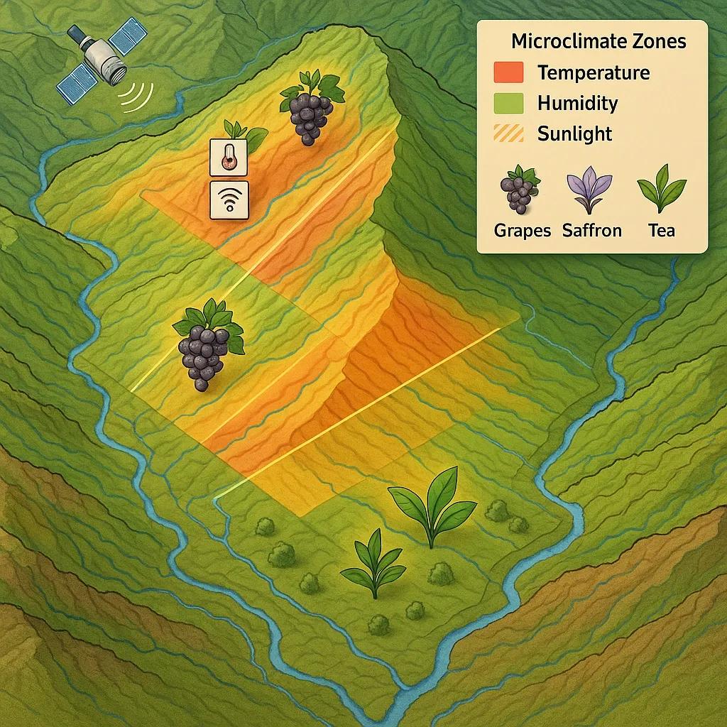
Microclimate mapping, a specialized application of geospatial technology, plays a pivotal role in optimizing agricultural practices for high-value crops. These crops, often sensitive to minute environmental variations, can experience significant improvements in yield, quality, and even the extension of their viable growing regions through precise microclimate identification. This article delves into the technical aspects of microclimate mapping, exploring its methodologies, underlying principles, and practical applications for cultivating niche pockets of high-value crops such as grapes, saffron, and tea.
Understanding Microclimates and Their Significance
A microclimate refers to the localized atmospheric conditions that differ from the surrounding regional climate. These variations can be influenced by a myriad of factors, including topography (slope, aspect, elevation), proximity to water bodies, vegetation cover, urban structures, and even soil properties. For high-value crops, these subtle differences are not merely academic; they are critical determinants of success.
For instance, grape varieties grown for fine wines exhibit distinct flavor profiles and chemical compositions influenced by temperature fluctuations, sunlight exposure, and drainage patterns. Saffron, derived from the stigmas, thrives in specific temperature ranges and requires well-drained soils. Tea quality is heavily dependent on factors like consistent rainfall, humidity, and cool temperatures, often found in high-altitude, misty regions. Identifying and leveraging these specific microclimatic nuances is paramount for maximizing the economic potential of such crops.
Methodologies for Microclimate Mapping
Microclimate mapping is a multi-faceted process that integrates various data sources and analytical techniques. The core methodologies can be broadly categorized into remote sensing, ground-based sensing, and predictive modeling.
1. Remote Sensing Techniques
Remote sensing, encompassing the use of satellites, aerial platforms (including UAVs), and other airborne sensors, provides a non-invasive and efficient way to gather spatially explicit data over large areas.
Thermal Infrared (TIR) Imagery: TIR sensors detect emitted thermal radiation, allowing for the mapping of surface temperature variations. Cooler areas often indicate higher moisture content or denser vegetation, while warmer areas might suggest drier conditions or exposed soil. For vineyards, TIR can identify areas prone to frost or heat stress.
Multispectral and Hyperspectral Imagery: These sensors capture reflected sunlight across various electromagnetic spectrum bands. Different bands are sensitive to various biophysical properties of vegetation, such as chlorophyll content, water stress, and nutrient deficiencies. For tea plantations, analyzing specific spectral signatures can help identify areas with optimal growth vigor or disease susceptibility.
Lidar (Light Detection and Ranging): Lidar technology uses pulsed laser light to measure distances, generating highly accurate 3D representations of the earth's surface. This data is invaluable for deriving detailed topographic features like elevation, slope, aspect, and terrain roughness, which are crucial determinants of air drainage, solar radiation incidence, and water runoff. For saffron cultivation, lidar can precisely identify well-drained, sun-exposed slopes.
Synthetic Aperture Radar (SAR): SAR can penetrate cloud cover and operate day or night, providing data on surface roughness and soil moisture. This is particularly useful in regions with persistent cloud cover, offering insights into localized hydrological conditions.
2. Ground-Based Sensing and IoT Integration
While remote sensing offers broad coverage, ground-based sensors provide granular, real-time data crucial for fine-tuning microclimate assessments.
Wireless Sensor Networks (WSNs) and IoT: Deploying networks of low-cost, interconnected sensors across a field allows for continuous monitoring of key environmental parameters. These sensors can measure air temperature, soil temperature, soil moisture content, relative humidity, wind speed and direction, and solar radiation at multiple points. The data collected by these Internet of Things (IoT) devices is transmitted wirelessly to a central hub for analysis. For high-value crops, strategically placed sensors can provide early warnings of frost events, water stress, or disease-conducive humidity levels.
Weather Stations: Traditional weather stations, though larger and less numerous than individual IoT sensors, provide reliable, calibrated data on a local scale, serving as critical ground truth for validating remote sensing products and informing predictive models.
3. Predictive Modeling and Spatial Interpolation
Raw sensor data and imagery need to be processed and integrated into spatial models to create comprehensive microclimate maps.
Geostatistical Interpolation: Techniques like Kriging or Inverse Distance Weighting (IDW) are used to estimate values at unsampled locations based on measurements from known points (e.g., ground sensors). This allows for the creation of continuous spatial maps of parameters like temperature or humidity.
Digital Elevation Models (DEMs) and Derived Products: DEMs, generated from lidar or photogrammetry, are fundamental. From DEMs, terrain derivatives such as slope, aspect (direction of slope), curvature, and topographic wetness index (TWI) can be calculated. These derivatives directly influence solar radiation distribution, air drainage patterns, and soil moisture accumulation.
Solar Radiation Models: Algorithms can simulate the amount of direct and diffuse solar radiation received at every point on a landscape, considering topography, time of year, and atmospheric conditions. This is vital for crops requiring specific light exposure, like grapes or certain tea varieties.
Air Drainage Models: These models simulate the flow of cold air downslope, identifying frost pockets - areas where cold air accumulates. This information is critical for mitigating frost damage in sensitive crops.
Microclimate Models: Sophisticated numerical models can integrate atmospheric conditions, terrain data, and surface properties to simulate temperature, humidity, and wind patterns at a fine spatial resolution. These models can predict future microclimatic conditions under different scenarios.
Application to High-Value Crops
The integrated approach of microclimate mapping offers specific benefits for each high-value crop:
Grapes
Microclimate mapping is transformative for viticulture.
Terroir Identification: By mapping temperature variations, solar radiation exposure, and soil drainage characteristics, winemakers can precisely identify "terroirs", unique environmental conditions that impart distinct characteristics to the wine. This allows for optimal grape variety selection for specific vineyard blocks.
Frost Risk Assessment: Air drainage models combined with thermal imagery identify frost-prone areas, enabling growers to implement protective measures like wind machines or overhead irrigation during critical periods.
Ripening Optimization: Understanding localized heat units and sunlight exposure helps predict ripening times and optimize harvesting schedules, leading to better sugar accumulation and phenolic maturity.
Disease Management: Humidity mapping can identify areas susceptible to fungal diseases like powdery mildew or botrytis, allowing for targeted fungicide applications and reduced chemical use.
Saffron
Saffron, the world's most expensive spice, has very specific climatic requirements.
Site Selection: Microclimate mapping helps identify ideal cultivation sites characterized by well-drained, slightly sloped land that receives ample sunlight but is protected from strong winds. Soil moisture mapping is crucial, as saffron corms are sensitive to waterlogging.
Temperature Monitoring: Continuous monitoring of soil and air temperature through IoT sensors ensures the optimal temperature range for corm development and flowering. Extreme temperatures can severely impact yield.
Irrigation Optimization: Soil moisture mapping and predictive models guide precise irrigation, preventing both water stress and waterlogging, which are detrimental to saffron.
Tea
Tea quality is highly sensitive to environmental conditions, making microclimate mapping invaluable for optimizing production.
Quality Enhancement: High-quality teas often thrive in misty, high-altitude regions with consistent rainfall and specific temperature ranges. Microclimate mapping helps identify these niche areas within larger plantations.
Yield Improvement: By understanding localized sun exposure, humidity, and temperature, growers can optimize planting densities and cultivation practices for maximum yield.
Pest and Disease Control: Mapping areas with specific humidity or temperature profiles can predict the incidence of pests like tea mites or diseases like blister blight, enabling proactive and targeted interventions.
Terroir Development: Similar to grapes, different tea gardens exhibit unique "terroirs." Microclimate mapping can help define these specific conditions, allowing for the production of distinct and highly valued tea varieties.
Challenges and Future Directions
Despite its significant advantages, microclimate mapping faces certain challenges. The initial setup cost for advanced sensors and software can be substantial. Data integration from disparate sources requires robust platforms and expertise. The sheer volume of data generated necessitates advanced analytical capabilities, often leveraging AI and machine learning for pattern recognition and predictive insights.
Future directions in microclimate mapping involve:
Increased Automation and AI Integration: Automated data collection, processing, and analysis using AI algorithms will further enhance efficiency and accuracy. Machine learning models can predict microclimatic responses to changing weather patterns with greater precision.
Higher Resolution Data: Advancements in sensor technology, particularly smaller and more powerful UAV-borne sensors, will enable even finer spatial and temporal resolution mapping.
Dynamic Modeling: Moving beyond static maps to dynamic, real-time microclimate simulations that update with changing weather conditions and plant growth stages.
Integration with Digital Twins: Creating digital twins of agricultural fields, where real-time microclimate data is fed into a virtual representation of the farm, enabling highly accurate simulations and predictive management.
Conclusion
Microclimate mapping is no longer a nascent concept but a sophisticated, indispensable tool for the cultivation of high-value crops. By meticulously identifying and understanding the nuanced environmental pockets that favor specific crop varieties, growers can achieve unparalleled levels of precision agriculture. This leads to not only enhanced yields and superior quality but also a more sustainable and economically viable agricultural sector, ensuring the continued flourishing of these prized commodities in a changing climate. As an entrepreneur providing digital transformation services using technologies like geospatial, remote sensing, UAVs, satellite imagery, IoT, BIM, digital twins, immersive technologies like XR, AI & ML, and customized software solutions, I recognize the immense potential of microclimate mapping as a cornerstone of modern, data-driven agriculture.