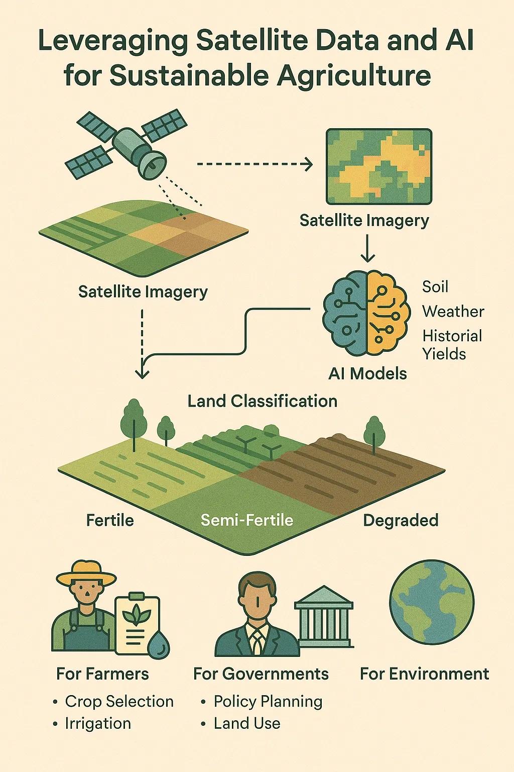
Agriculture faces mounting pressure to produce more food with fewer resources while minimizing environmental damage. Traditional farming methods rely on manual surveys, seasonal experience, and reactive interventions. This often leads to suboptimal land use, soil degradation, excessive chemical input, and water scarcity. Sagri (Japan) has pioneered the use of satellite data and AI to address these issues. By integrating geospatial intelligence with predictive analytics, Sagri enables farmers and policymakers to optimize land use and move towards sustainable farming practices.
The Problem It Solves
The agricultural sector struggles with three interlinked challenges:
Land Use Inefficiency Much of farmland is underutilized or mismanaged, with crop selection and rotation often disconnected from actual soil and climatic conditions.
Environmental Degradation Overuse of fertilizers and pesticides pollutes water bodies, reduces soil fertility, and accelerates biodiversity loss.
Climate Variability Unpredictable weather patterns make planning and yield forecasting increasingly unreliable.
Traditional methods cannot keep pace with these rapidly evolving challenges. A data-driven approach is needed to guide smarter, more sustainable land use decisions.
Core Technology: Satellite Data + AI
Sagri’s platform combines two key technologies:
1. Satellite Remote Sensing
o Tracks vegetation indices (NDVI, EVI).
o Monitors soil moisture and land temperature.
o Detects land use changes over large areas in near real time.
2. Artificial Intelligence Models
o Predicts crop suitability based on soil, weather, and historical yield data.
o Automates land classification into fertile, semi-fertile, or degraded zones.
o Optimizes resource allocation (fertilizer, irrigation, pesticides).
Together, these tools provide a comprehensive decision-support system (DSS) for landowners, cooperatives, and government agencies.
Adoption Paths
1. For Farmers
o Mobile-based advisory apps offering crop recommendations.
o Alerts for irrigation timing and pest risks.
o ROI insights from shifting to optimized land use.
2. For Governments
o Monitoring agricultural subsidies’ impact.
o Land use planning aligned with food security goals.
o Tracking compliance with sustainability standards.
3. For Agribusinesses
o Better sourcing decisions through verified crop condition data.
o Supply chain resilience by predicting yield fluctuations.
o Integration with carbon credit markets by quantifying emissions avoided.
Case Example: Optimizing Rice and Wheat Rotation
In India and Japan, farmers traditionally grow rice and wheat without real-time soil monitoring. This causes groundwater depletion and soil fatigue. By applying Sagri’s AI models, farmers can:
Identify zones suitable for alternative crops (pulses, millets).
Reduce water-intensive cultivation in fragile areas.
Increase overall farm income by diversifying production.
This directly addresses food security while reducing environmental stress.
Benefits and ROI
For Farmers
Higher yields from optimized crop choices.
Reduced input costs (fertilizer, water, pesticides).
Lower crop failure risk from climate variability.
For Governments
Evidence-based policy making.
Transparency in subsidy allocation.
Improved national food security indices.
For the Planet
Reduced greenhouse gas emissions.
Better soil and water conservation.
Protection of biodiversity and ecosystems.
Future Outlook
The fusion of satellite data and AI is shaping agriculture into a precision, data-driven industry. Future expansions may include:
Integration with UAVs and IoT sensors for hyper-local monitoring.
Blockchain traceability for sustainable produce verification.
Global scalability to extend land optimization practices to emerging economies.
Would you adopt such a system now, or wait for AI and satellite tech to mature further?