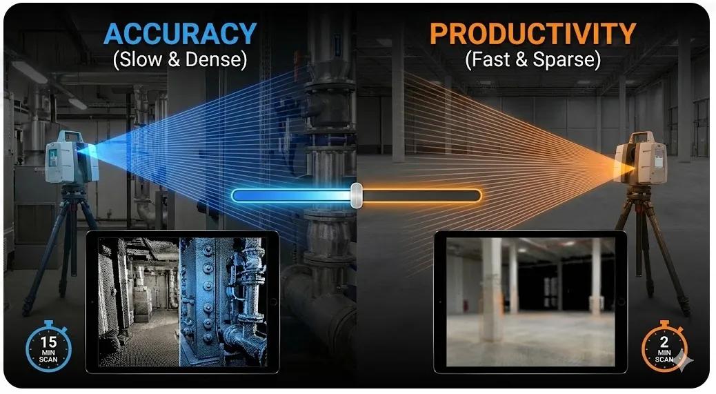
Laser scanning has become a default choice for reality capture on many construction projects. Its promise is compelling: dense point clouds, millimeter accuracy, and reliable as-built verification. Yet projects often struggle to extract value from scanning, not because the technology fails, but because accuracy and productivity are rarely balanced intentionally .
Some teams scan everything at the highest resolution possible, overwhelming storage and processing pipelines. Others prioritize speed and coverage, only to discover later that the data is insufficient for tolerance checks or BIM validation.
Laser scanning is not about maximizing accuracy or minimizing time. It is about choosing the right accuracy for the decision being made .
This article explains the key trade-offs in laser scanning workflows and how to design scanning strategies that balance precision, speed, and operational value.
1. Why “Maximum Accuracy” Is a Misleading Goal
Modern terrestrial laser scanners can capture millions of points per second. This capability often leads to a false assumption:
More points = better outcomes
In reality:
Excessive density increases scan time
Registration becomes more complex
File sizes grow exponentially
BIM integration slows down
Field teams wait longer for usable outputs
Accuracy beyond what the construction task requires does not add value, it adds friction.
2. Understanding Accuracy in Practical Terms
Laser scanning accuracy has multiple dimensions:
Instrument accuracy (manufacturer specification)
Registration accuracy (how scans align together)
Control accuracy (alignment to survey control)
Effective accuracy (what the field decision actually needs)
For BIM-to-field workflows, effective accuracy is what matters most.
Example:
A ±5 mm deviation may be acceptable for wall placement
The same deviation may be unacceptable for prefabricated MEP systems
Accuracy must be defined by use case , not by scanner capability.
3. Productivity Drivers in Laser Scanning
Productivity is influenced by more than scan speed.
Key factors include:
Number of scan positions
Scan resolution and quality settings
Site accessibility and obstructions
Registration strategy (targets vs cloud-to-cloud)
Processing and QA time
High-resolution scans with poor planning often reduce overall productivity.
4. Resolution vs Coverage: The Core Trade-off
Decision Factor - Higher Resolution - Wider Coverage
Scan time - Longer - Shorter
Data volume - Very high - Moderate
Registration effort - Complex - Simpler
Accuracy at edges - Better - Lower
BIM usability - Slower - Faster
The optimal workflow often combines:
High-resolution scans at critical interfaces
Lower-resolution scans for context and progress
5. Matching Scan Strategy to Construction Phase
Early Construction
Focus: alignment, layout, structure
Strategy: moderate resolution, wide coverage
Structural & MEP Phases
Focus: tolerances, interfaces
Strategy: targeted high-resolution scanning
Fit-Out
Focus: clearances, finishes
Strategy: selective, high-precision scans
Handover
Focus: verification, record
Strategy: comprehensive but optimized scanning
Scanning everything the same way across all phases is inefficient.
6. Registration Strategy: Accuracy vs Speed
Target-Based Registration
✔ Higher reliability
✔ Better global accuracy
✖ Requires setup time
✖ Slower on large sites
Cloud-to-Cloud Registration
✔ Faster capture
✔ Fewer physical targets
✖ Sensitive to geometry quality
✖ Risk of drift over large areas
Field-grade workflows often combine both:
Targets for control
Cloud-to-cloud for local efficiency
7. Control Points: Accuracy Without Excess
Control improves accuracy, but too many control points slow down workflows.
Best practice:
Establish a stable survey backbone
Use control points strategically
Avoid over-constraining the dataset
The goal is confidence , not mathematical perfection.
8. Data Density vs BIM Integration
Dense point clouds do not automatically integrate better with BIM.
Challenges include:
Heavy files
Slow viewers
Complex clipping
Difficult deviation analysis
Optimized workflows:
Segment point clouds by zone
Decimate where precision is not needed
Preserve density only at interfaces
BIM benefits from intelligent filtering , not raw volume.
9. When Laser Scanning Is Overkill
Laser scanning may not be necessary for:
Early visual progress checks
Large earthworks
Non-critical temporary works
In such cases, UAV photogrammetry or simpler methods may provide sufficient insight at lower cost and faster turnaround.
10. The Field Test for Laser Scanning Strategy
Before scanning, ask:
What decision will this scan support, and what accuracy does that decision require?
If this cannot be answered, the scan plan is incomplete.
Conclusion
Laser scanning is one of the most powerful tools in BIM-to-field workflows, but only when used deliberately.
When accuracy and productivity are balanced:
Scans arrive on time
Data integrates smoothly with BIM
Deviations are meaningful
Field teams trust the results
When scanning is driven by technology alone:
Data overwhelms workflows
Costs rise
Decisions slow down
In construction, the best scan is not the most accurate one, it is the one that enables the right decision at the right time .