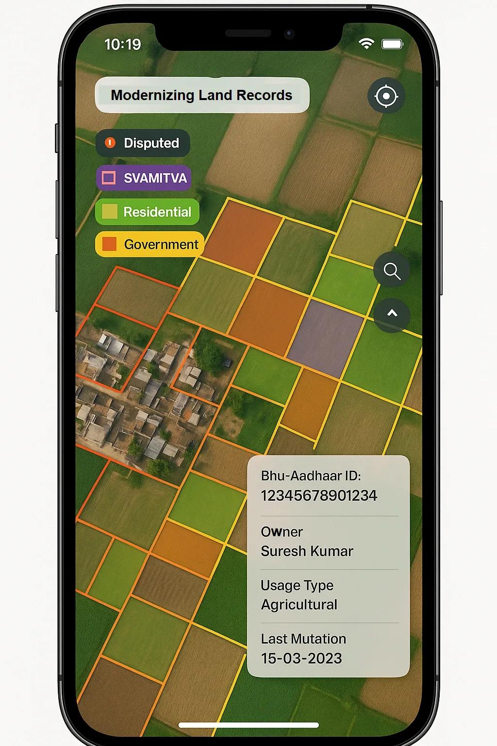
India’s land administration system has long been marked by fragmentation, opacity, and inefficiencies. Land records are often paper-based, outdated, and misaligned with actual ground realities. Disputes over ownership, boundaries, and tenure rights persist, especially in rural areas, impacting livelihoods, credit access, and infrastructure development. The Digital India Land Records Modernization Programme (DILRMP) aims to resolve these challenges through digitization, integration, and transparency. Central to this transformation is the geospatial stack, a layered set of digital tools and datasets built on location intelligence, offering a real opportunity for precise and scalable land governance.
1. The Case for Land Record Modernization
India's rural economy still depends heavily on land, yet the legal and administrative mechanisms to define, update, and secure land ownership are insufficiently digitized or integrated. Some key challenges include:
Fragmented Records : Land title, ownership, registry, and tax records reside in separate departments.
Unclear Boundaries : No reliable geospatial maps linked to ownership data.
High Dispute Rates : Land disputes form nearly two-thirds of civil litigation.
Low Credit Flow : Ambiguity in land rights hampers rural credit and farm investments.
Modernizing land records not only improves governance but unlocks value in agriculture, infrastructure, and real estate. With over 600,000 villages, India’s rural land digitization requires a scalable, accurate, and integrated approach. That’s where cadastral intelligence and India’s evolving geospatial stack come in.
2. Cadastral Intelligence: The Foundation
Cadastral maps form the base layer of land information, detailed boundaries of plots, holdings, ownership data, and usage type. When these maps are digitized and geo-referenced with satellite or drone imagery, they become the core of land-related intelligence.
Cadastral intelligence combines:
Survey-grade geospatial data (from satellites, drones, and GNSS)
Ownership metadata (title records, mutation history)
Attribute layers (land use, soil, water access, tenancy rights)
Analytics tools (for pattern recognition, land aggregation, land value indexing)
Such intelligence feeds directly into applications for rural governance, agrarian reform, welfare targeting, and digital infrastructure rollout.
3. India’s Geospatial Stack: Building Blocks for Land Digitization
With the 2021 release of India’s new Geospatial Data Policy, the country is building its own open and interoperable geospatial stack, mirroring what Aadhaar did for identity and UPI for payments.
Key layers relevant to land record modernization:
A. Bhuvan (ISRO’s Geoportal)
Provides base maps, satellite imagery, and services like land use classification and village-level mapping. Ideal for overlaying cadastral boundaries on high-resolution terrain imagery.
B. SVAMITVA Scheme
Under the Ministry of Panchayati Raj, SVAMITVA uses drones to map rural habitations and provides property cards to homeowners. It marks the beginning of geospatial property titling in rural India.
C. Bhu-Aadhaar (Unique Land Parcel Identification Number)
Like Aadhaar for land parcels, every plot gets a 14-digit unique ID tied to spatial coordinates, ownership, and usage. This builds a uniform system to avoid duplication or fraud.
D. National Geospatial Policy 2022
Encourages open access to foundational geospatial data and private sector collaboration in land-based services, mapping, and analytics.
E. API Ecosystem and Standards
NIC and Survey of India are developing APIs and standards for land mapping, cadastral data storage, and integration with financial and planning systems.
4. Use Cases in Rural Governance
i. Dispute Resolution and Title Certainty
Geo-referenced land parcels, when verified through community engagement and matched with government records, can reduce litigation by making ownership transparent and accessible.
ii. Property Tax and Revenue Mobilization
Panchayats can link land usage and ownership with taxation modules using geospatial overlays, helping local bodies boost self-revenue.
iii. Digital Welfare Targeting
Landholding data can integrate with beneficiary databases to accurately target schemes like PM-KISAN, MGNREGA, or soil health card programs.
iv. Infrastructure Planning
Rural roads, water bodies, power lines, and public buildings can be planned using accurate digital land maps, avoiding acquisition delays or overlaps.
v. Agrarian and Tenancy Reforms
Geospatial mapping enables visualization of landholding patterns, tenant farmers, and fallow land, supporting reforms and cooperative farming models.
5. Technology Stack: From Data to Insights
The modernization effort involves a layered technical stack:
Layer - Technology
Base Imagery - Satellite (CartoSAT, Sentinel), Drones, LiDAR
Ground Control - GNSS Survey, RTK, ETS
Cadastral Digitization - GIS-based Parcel Mapping (QGIS, ArcGIS, etc.)
Data Integration - APIs linking ownership records, RoRs, registry data
Analytics - Land use analysis, valuation, encroachment alerts
Visualization - Panchayat dashboards, mobile apps, land heatmaps
Governance - E-signatures, blockchain audit trails, public access
Emerging technologies like blockchain (for tamper-proof land records), AI/ML (for pattern recognition and anomaly detection), and Digital Twins (for land use simulation) can be layered onto this stack for richer applications.
6. Challenges to Watch
Despite progress, several issues need resolution:
Data Silos : Land records often reside in silos across departments, revenue, registry, panchayats, etc.
Lack of Skilled Workforce : Local-level GIS professionals and surveyors are in short supply.
Institutional Inertia : Resistance to workflow changes and data sharing between departments.
Community Buy-in : Digital maps must be validated and accepted by communities to prevent social resistance.
Legal Reform : India still follows a presumptive titling system , not a conclusive one . Tech must go hand in hand with legal clarity.
7. Roadmap for Scalable Implementation
To make this opportunity viable at scale, India should follow a phased, standards-based approach:
Baseline Mapping Digitize and geo-reference existing paper maps and ownership records at village level.
Ground Truthing Use drones or ETS + GNSS surveys to validate and refine parcel boundaries with community input.
Parcel ID Assignment Roll out Bhu-Aadhaar IDs linked to all datasets, ownership, usage, tenancy, and amenities.
Integration with Government Systems Link land records with registration offices, banks, welfare databases, and taxation systems via APIs.
Public Access and Grievance Redressal Build mobile-friendly portals for citizens to view, verify, and dispute records.
Skill Development and Standards Train panchayat staff and state-level GIS teams; follow common open standards to ensure interoperability.
Conclusion
India’s push for land record modernization is more than a digitization effort, it’s a reimagination of how land, identity, and governance interact in the rural economy. The geospatial stack, combined with cadastral intelligence, offers a robust foundation for this transformation. If implemented thoughtfully, it can reduce disputes, empower rural citizens, enable better planning, and unlock billions in land value.
The success of this initiative depends on collaboration across state agencies, community participation, and technology partners who can deliver scalable, low-cost, and interoperable solutions. It’s a defining moment to turn India’s fragmented land systems into a digital public good, with clarity, accuracy, and accountability at its core.