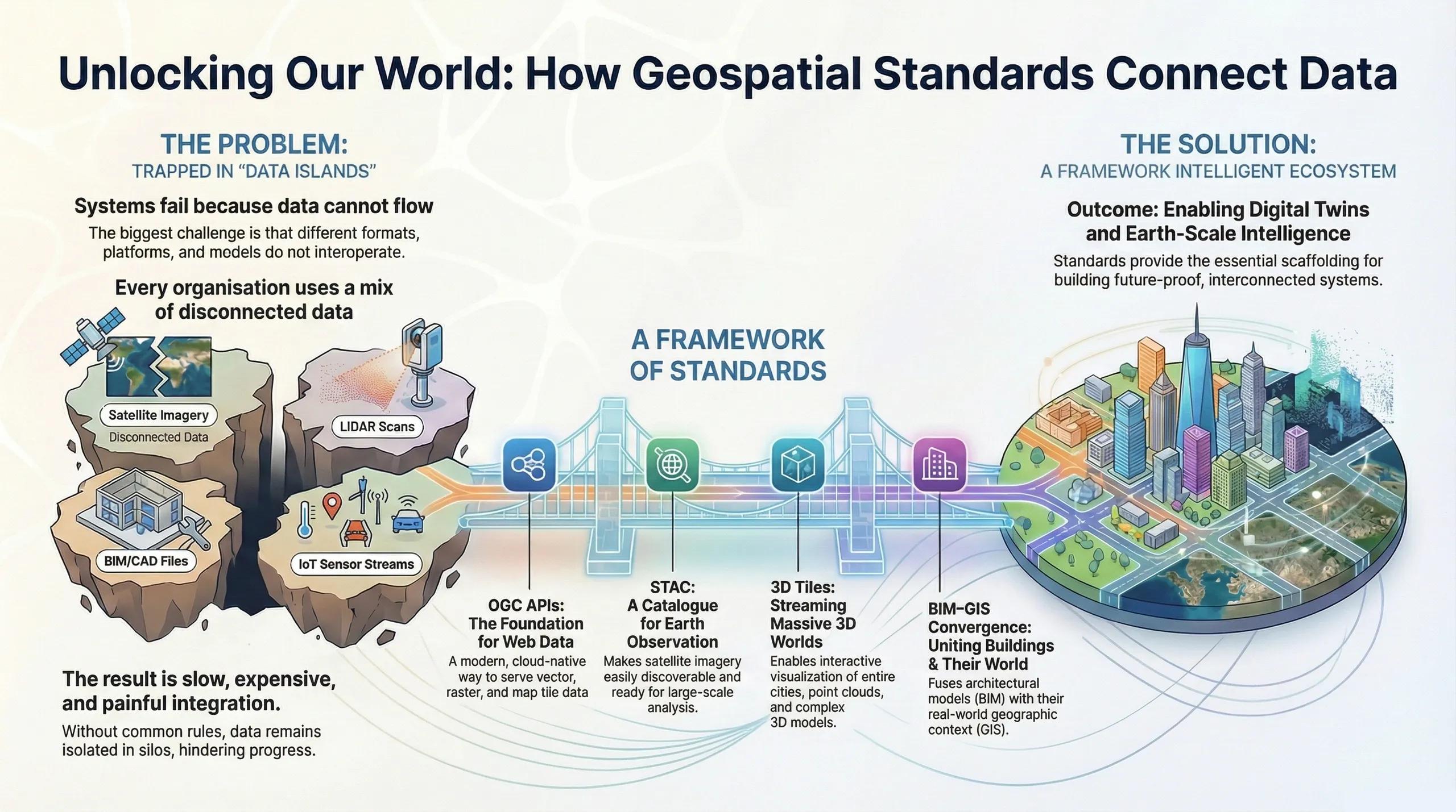
What if every dataset, from satellite imagery to BIM models to IoT streams, could talk to each other without friction?
Modern geospatial systems do not fail because of lack of data.
They fail because data cannot flow , formats don’t align , platforms don’t interoperate , and models cannot consume heterogeneous inputs .
Interoperability is the invisible infrastructure that holds the geospatial ecosystem together.
Standards like OGC APIs , STAC , 3D Tiles , and BIM–GIS connectors are the backbone of Earth-scale computing, digital twins, and decision intelligence.
This article explains why standards matter, and how they enable scalable, future-proof geospatial systems.
1️⃣ The Case for Standards: Solving the “Data Islands” Problem
Every organization collects:
satellite imagery
vector GIS layers
CAD/BIM files
LiDAR scans
IoT sensor streams
terrain models
unstructured tabular data
The problem? These datasets often operate in silos , making integration painful, slow, and expensive.
Standards solve this by ensuring:
common formats
machine-readable metadata
consistent coordinate frameworks
discoverability
streaming at scale
cross-platform usability
Interoperability turns data islands into connected geospatial infrastructure .
2️⃣ OGC APIs, The Foundation of Geospatial Web Services
OGC (Open Geospatial Consortium) defines the majority of geospatial standards used worldwide.
The new generation of OGC APIs replaces legacy WMS/WFS/WCS with RESTful, cloud-native, scalable services .
Key OGC APIs:
OGC API – Features
Serves vector data over REST.
Replaces WFS.
OGC API – Tiles
Serves tiled map content at high performance.
Replaces TMS/WMTS.
OGC API – Coverages
Serves raster & gridded data (DEM, soil moisture, NDVI).
Replaces WCS.
OGC API – Records
Metadata discovery for catalogs.
Why it matters:
OGC APIs make GIS datasets queryable, filterable, lightweight, and cloud-native , foundational for digital twins and analytics pipelines.
3️⃣ STAC, The Metadata Standard That Transformed EO
The SpatioTemporal Asset Catalog (STAC) standardizes how Earth Observation data is indexed, stored, and discovered.
Every satellite image becomes:
a JSON document
with spatial/temporal footprints
spectral metadata
processing level
asset links
Why STAC matters:
cloud-ready
massively scalable
lets EO users build pipelines without manual file management
used by Microsoft Planetary Computer, Earth Engine, Radiant Earth, and AWS Open Data
STAC enables global EO discovery at internet scale .
4️⃣ 3D Tiles, The Streaming Standard for Massive 3D Data
Developed by Cesium, 3D Tiles allows streaming of:
LiDAR point clouds
photogrammetry meshes
BIM models
3D buildings
terrain
interior spaces
Key benefits:
level-of-detail (LOD) rendering
spatial indexing
GPU-optimized data structures
global visualization capability
Without 3D Tiles, modern 3D digital twins , urban twins , and campus models would not scale beyond small datasets.
5️⃣ BIM–GIS Convergence, Building the Connected Built Environment Layer
CAD/BIM and GIS historically lived in separate worlds:
BIM → building interiors and design intent
GIS → surrounding context and real-world constraints
Modern projects require both.
Thus, standards now bridge them:
IFC (Industry Foundation Classes)
Open BIM format for geometry + semantics.
CityGML / CityJSON
GIS format for city-scale 3D models.
IFC + 3D Tiles Pipelines
Allow BIM models to be streamed into GIS viewers.
Georeferencing Standards
Make BIM coordinate systems align with real-world geospatial CRS frameworks.
OpenBIM connectors
Link Revit/IFC → GIS platforms (QGIS, ArcGIS, Cesium, Unreal, etc.)
The result: BIM-GIS fused models enabling construction monitoring, asset management, and urban digital twins.
6️⃣ Sensor Interoperability, IoT + EO + GIS
Standards extend beyond files to real-time streams :
MQTT, AMQP, Kafka
Frameworks for streaming IoT data.
OGC SensorThings API
Standard for IoT device metadata, observations, and queries.
OGC SWE (Sensor Web Enablement)
Legacy but still used for sensor discovery and tasking.
These standards allow digital twins to incorporate sensors without bespoke integrations .
7️⃣ Interoperability in Digital Twins, Why It’s Critical
Digital twins depend on:
cross-domain models
multi-sensor fusion
integration across soil, water, crop, climate, infrastructure
cloud streaming
spatial indexing
bidirectional data flow
A digital twin is not a single dataset, it is a living system that ingests, processes, and outputs data continuously.
Without standards → twins become brittle.
With standards → twins become extensible and future-proof .
8️⃣ India: Why Standards Should Be Adopted Aggressively
India’s digital ecosystem is expanding fast:
Digital Agriculture Mission
Smart Cities
Digital Public Infrastructure
Forest carbon MRV
Digital twins for water, urban systems, and climate
Large-scale EO programs (NRSC, ISRO, Bhuvan)
Standards ensure interoperability between ministries, states, platforms, and private providers.
Without them, duplication and fragmentation will grow.
Conclusion
Interoperability is the secret scaffolding behind geospatial transformation.
OGC APIs supply the foundation.
STAC provides discoverability.
3D Tiles enable visualization at scale.
BIM–GIS standards unify the built environment.
Sensor standards feed real-time data.
Together, they unlock Earth-scale intelligence.
Modern geospatial systems aren’t built from data, they’re built from standards that allow data to connect .