For decades, infrastructure resilience was treated mainly as an engineering problem.
Stronger bridges. Better drainage. Safer buildings. More reliable power systems. Deeper foundations. Higher design standards.
All of that still matters.
But the real pressure on infrastructure is changing.
Today, infrastructure assets do not fail only because concrete cracks, transformers overheat, roads flood, or cables burn. They fail because the warning signals were scattered across too many systems, too many departments, and too many disconnected workflows.
The sensor had one version of truth.
The GIS map had another.
The BIM model was stored somewhere else.
The maintenance record was outdated.
The risk dashboard showed a trend but did not trigger action.
The field team had local knowledge, but that knowledge never entered the system.
The management team saw reports, not real-time operational context.
This is why infrastructure resilience is no longer only a civil engineering challenge.
It is becoming a data orchestration challenge.
The next phase of resilience will not be won by creating more dashboards. It will be won by connecting the evidence.
Assets. Sensors. Maps. Models. Inspections. Weather. Satellite data. UAV imagery. Maintenance logs. Field reports. AI alerts. Work orders. Compliance records.
When these remain disconnected, resilience becomes reactive.
When they are orchestrated, resilience becomes operational.
The new resilience gap
Most infrastructure organizations already have data.
They have asset inventories.
They have GIS layers.
They have CAD and BIM files.
They have IoT sensors.
They have SCADA systems.
They have inspection images.
They have ERP and maintenance platforms.
They have project reports, compliance records, and field updates.
The problem is not the absence of data.
The problem is the absence of continuity.
Data exists, but it does not flow into decisions fast enough.
A road agency may know which locations flood repeatedly, but that insight may not connect to drainage maintenance, emergency response, traffic diversion, and capital planning.
A utility may have transformer data, but if temperature, load, vegetation, location, and maintenance history are not analyzed together, risk remains invisible until failure happens.
A building may have electrical systems, fire alarms, IoT sensors, floor plans, and facility teams. But if short-circuit risk is not connected to asset location, sensor alerts, inspection workflows, and response protocols, safety remains fragmented.
A city may have cameras, weather feeds, flood maps, emergency teams, and citizen reports. But if these systems do not speak to each other, the city is still operating in silos.
That is the real resilience gap.
Not data shortage.
Data fragmentation.
From asset visibility to operational intelligence
Many digital twin projects still begin with the wrong question:
“How do we visualize the asset?”
A better question is:
“How do we make the asset operationally understandable?”
Visualization is useful, but it is not enough.
A 3D model of a bridge does not make the bridge resilient.
A dashboard of sensor readings does not make a factory safe.
A map of flood-prone areas does not make a city prepared.
A digital twin becomes meaningful only when it connects physical reality to operational action.
That means the twin must answer practical questions.
What is happening?
Where is it happening?
Which asset is affected?
What is the risk level?
Who needs to act?
What evidence supports the decision?
What workflow should be triggered?
What has already been done?
What should be monitored next?
This is where geospatial intelligence becomes central.
Every infrastructure risk has a location.
Every asset sits in a physical environment.
Every failure has spatial consequences.
Every response has a route, boundary, jurisdiction, access constraint, and operational context.
So resilience cannot be managed only through spreadsheets and static reports.
It needs a spatial operating layer.
Why IoT alone is not enough
IoT is becoming a major part of infrastructure safety.
For example, electrical risk monitoring in buildings and utilities can benefit from sensors that detect overheating, abnormal load, short-circuit patterns, smoke, humidity, or equipment stress.
But sensors alone do not create resilience.
A sensor only produces a signal.
The value begins when that signal is connected to the asset map, building layout, maintenance record, risk rules, escalation protocol, and response team.
Without orchestration, IoT becomes another alert stream.
With orchestration, IoT becomes an early-warning system.
The difference is not hardware.
The difference is architecture.
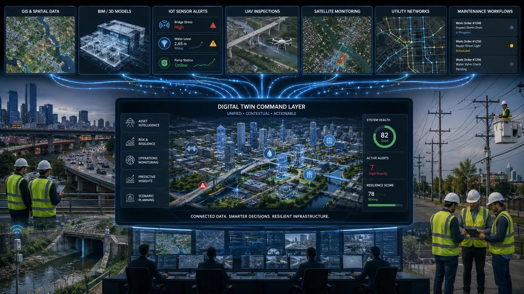
A resilient infrastructure system needs to connect:
Sensor data for real-time condition monitoring.
GIS for location and network context.
BIM for asset and facility structure.
AI for pattern detection and risk prediction.
UAV and satellite data for external observation.
Workflow systems for inspection, maintenance, and response.
Dashboards for management visibility.
Compliance records for audit and accountability.
This is the shift from monitoring to decision intelligence.
AI infrastructure makes this even more urgent
The rise of AI data centers is a good example.
A data center is not just a technology asset.
It is a geospatial asset.
It needs land.
It needs power.
It needs water.
It needs cooling.
It needs fiber connectivity.
It needs logistics access.
It faces flood risk, heat exposure, permitting constraints, grid dependency, and community impact.
As AI infrastructure expands, resilience planning cannot stop at server capacity or cloud demand. It must include location intelligence.
Where should the facility be located?
Can the grid support it?
Is the area exposed to water stress?
What is the long-term climate risk?
How will cooling demand affect local resources?
What happens if a flood, heatwave, or grid failure occurs?
What backup systems are needed?
Which routes support emergency access and equipment movement?
These are not purely IT questions.
They are geospatial resilience questions.
The same applies to airports, industrial parks, logistics hubs, power corridors, smart cities, ports, rail networks, and public utilities.
Infrastructure is becoming more connected, more automated, and more dependent on real-time intelligence. That makes data orchestration a strategic requirement.
Remote sensing is becoming operational
Satellite and UAV data are also moving from observation to response.
Wildfire detection is a clear example.
Thermal satellites, AI detection models, and emergency response workflows can now work together to identify fire signatures, locate incidents, and route intelligence to responders.
But the same model applies elsewhere.
Flood monitoring.
Forest loss.
Illegal mining.
Land encroachment.
Heat islands.
Coastal erosion.
Utility corridor risk.
Infrastructure deformation.
Disaster response.
The value is not only in seeing the event.
The value is in converting detection into action.
That requires an operating chain:
Detect.
Locate.
Verify.
Prioritize.
Assign.
Respond.
Record.
Learn.
This chain is where geospatial intelligence, AI, digital twins, and workflows converge.
The next digital twin is not an object. It is an ecosystem.
The first generation of digital twins was often asset-focused.
A building twin.
A plant twin.
A bridge twin.
A city model.
The next generation will be ecosystem-focused.
Assets, people, risks, sensors, environment, operations, and decisions will need to work together.
A smart city twin cannot only show roads and buildings. It must connect traffic, flooding, utilities, public safety, construction, climate exposure, and citizen services.
An industrial twin cannot only show machinery. It must connect energy, safety, quality, maintenance, emissions, logistics, and workforce movement.
A utility twin cannot only show network assets. It must connect load, outage risk, vegetation, weather, customers, field crews, and emergency response.
This is the real meaning of an operational digital twin.
Not a beautiful 3D replica.
A connected system for faster, safer, and more accountable decisions.
The leadership question
For infrastructure leaders, the question is no longer:
“Do we have enough data?”
The better question is:
“Can our data support action when risk is rising?”
If a building shows electrical risk, can the system trigger inspection before failure?
If a road corridor is flood-prone, can maintenance and emergency teams act before disruption?
If a data center location faces water or grid stress, can planners see the risk before investment?
If a utility asset shows early warning signs, can the organization prioritize response based on location, criticality, and consequence?
If a city detects a hazard, can it convert that signal into coordinated action?
This is where resilience becomes measurable.
Not through reports alone.
Through response time, risk reduction, avoided downtime, improved safety, better planning, and defensible decisions.
My view
Infrastructure resilience will increasingly depend on one core capability:
The ability to orchestrate data from the physical world into decisions that protect people, assets, and operations.
That is why GIS, BIM, IoT, AI, UAVs, satellites, and digital twins should not be treated as separate technology investments.
They are parts of the same resilience stack.
The organizations that win will not be those with the most data.
They will be those that connect the right data, at the right time, to the right decision.
Because the future of infrastructure resilience is not only about building stronger assets.
It is about building smarter operating systems around them.