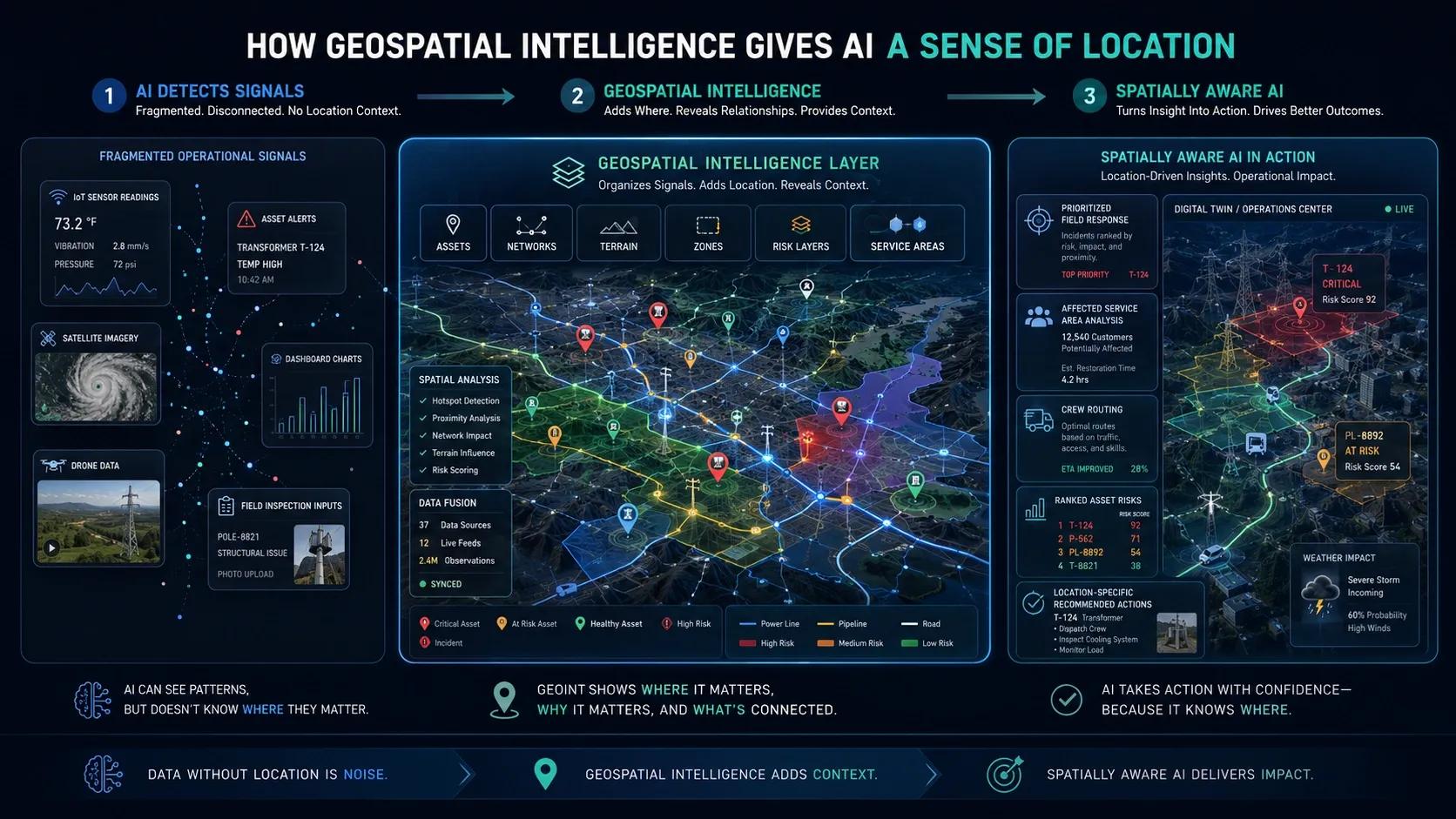
Artificial Intelligence can process large volumes of data.
It can detect patterns.
It can classify images.
It can predict failures.
It can identify anomalies.
It can recommend actions.
It can automate reports.
But for enterprise operations, one question often decides whether AI becomes useful or incomplete:
Where is it happening?
A risk may be detected.
An asset may be failing.
A road may be damaged.
A pipeline may be leaking.
A field may be under stress.
A building zone may be consuming more energy.
A city may be facing flood risk.
A port may be experiencing congestion.
In each case, the location matters.
AI may identify the signal, but geospatial intelligence helps explain where the signal exists, what it affects, how it spreads, who is impacted, and what response is possible.
This is why geospatial intelligence gives AI a sense of location.
AI Can Detect, But Location Gives Meaning
AI can detect an anomaly in a sensor reading.
But the operational meaning changes depending on where that sensor is located.
A high-temperature alert in one part of a facility may be normal.
The same alert in another zone may indicate safety risk.
A road defect in a low-traffic area may be a routine maintenance issue.
The same defect near a school, hospital, junction, or accident-prone corridor may require urgent action.
A utility outage in a low-density area may affect a few customers.
The same outage in a dense urban zone may affect thousands.
A flood alert in an open area may be manageable.
The same alert in a vulnerable neighborhood may require immediate response.
This is the difference between data and spatial context.
AI may identify what is happening.
Geospatial intelligence helps understand where it matters.
Why Location Is Operational Context
Location is not just a point on a map.
In enterprise operations, location carries context.
It tells us:
where an asset exists,
what it is connected to,
which area it serves,
who may be affected,
which route is available,
what risks surround it,
which team is closest,
what terrain or access constraints exist,
how one event may impact nearby systems.
This is why location becomes an operational layer.
For asset-heavy sectors, location helps connect data to reality.
It connects the physical world with decisions.
Without location, AI may understand a pattern but miss the operational consequences of that pattern.
Geospatial Intelligence Connects Assets to Place
Every physical asset exists somewhere.
A transformer is located in a network.
A pump is installed in a plant.
A road segment belongs to a corridor.
A building system serves a specific zone.
A pipe runs through a specific alignment.
A sensor is attached to a physical location.
A field asset is located within terrain, weather, and access conditions.
Geospatial intelligence connects the asset to its place.
This helps AI understand not only the asset condition, but the asset’s surroundings, dependencies, and impact area.
For example, if AI predicts that a transformer may fail, geospatial context can help answer:
Where is the transformer?
Which customers will be affected?
Which nearby assets are connected?
Which field crew is closest?
What access route is available?
Is the area flood-prone?
Are there any planned works nearby?
What is the priority compared with other assets?
This turns AI from a prediction engine into an operational decision-support system.
Location Helps AI Understand Relationships
Enterprise operations are not made of isolated objects.
They are made of relationships.
Roads connect locations.
Pipelines connect supply and demand.
Utility networks connect assets and customers.
Buildings connect floors, rooms, systems, and occupants.
Ports connect berths, yards, equipment, cargo, vessels, and routes.
Cities connect infrastructure, services, people, risks, and mobility.
Geospatial intelligence helps represent these relationships.
AI can then understand proximity, network connectivity, service areas, spatial clusters, corridors, catchments, routes, zones, and boundaries.
This is important because operational decisions often depend on relationships.
A problem in one asset may affect downstream assets.
A blocked road may affect emergency response.
A drainage issue may increase flood risk in nearby low-lying areas.
A warehouse bottleneck may affect movement across loading zones.
A utility failure may affect a defined service area.
AI without spatial relationships may detect individual events.
AI with geospatial intelligence can understand system-level impact.
Why Proximity Matters
Many operational decisions depend on proximity.
Which team is closest?
Which asset is nearby?
Which risk is spreading?
Which route is shortest?
Which location is most exposed?
Which service area is impacted?
Which neighboring assets may be affected?
For example, in field service operations, AI may recommend sending a team to inspect an asset. But without geospatial intelligence, the system may not know which team is closest, which route is accessible, or whether nearby work can be combined.
In emergency response, AI may predict a high-risk zone. But geospatial intelligence is needed to identify hospitals, schools, vulnerable populations, road access, safe routes, and response coverage.
In logistics, AI may optimize delivery sequences. But location context is essential to understand traffic, restrictions, distance, route feasibility, and delivery density.
Proximity turns insight into practical action.
Why Terrain and Environment Matter
Location is not only about coordinates.
Terrain and environmental conditions also matter.
Slope affects water flow.
Elevation affects flood risk.
Land use affects exposure.
Soil conditions affect construction and agriculture.
Weather affects operations.
Vegetation affects utility corridors.
Traffic affects response time.
Urban density affects impact.
AI models that ignore terrain and environmental context may produce recommendations that are technically incomplete.
For example:
A flood model needs elevation, drainage, land cover, rainfall, and built-up areas.
An agriculture model needs soil, slope, crop type, moisture, vegetation condition, and weather.
A road maintenance model needs pavement condition, traffic, drainage, road geometry, and accident history.
A utility risk model needs asset location, vegetation proximity, weather exposure, terrain, and network topology.
Geospatial intelligence brings these layers together.
It helps AI understand the physical environment in which operations take place.
Geospatial Intelligence Supports Digital Twins
Digital Twins are often discussed as 3D models, asset dashboards, or simulation environments.
But a Digital Twin becomes much more powerful when geospatial intelligence is integrated.
GIS provides the spatial foundation.
BIM provides engineering and asset detail.
IoT provides live operational signals.
AI provides analytics and prediction.
Workflows convert insights into action.
Geospatial intelligence helps connect these layers into one operating environment.
It gives the Digital Twin a sense of place, scale, relationship, and impact.
For a building, this may mean connecting rooms, floors, equipment, occupancy, comfort, and energy use.
For a city, this may mean connecting roads, drains, utilities, buildings, land use, risk zones, and emergency response.
For a utility, this may mean connecting network topology, asset condition, customers, service areas, outages, and field crews.
For a port, this may mean connecting berth operations, yard movement, cargo flow, equipment, vessels, safety zones, and emissions.
In each case, geospatial intelligence helps the Digital Twin become operationally meaningful.
From AI Alerts to Spatially Aware Decisions
AI alerts become more useful when they are spatially aware.
Instead of only saying:
“Risk detected.”
The system can show:
Risk detected in Zone 4.
Nearby assets are also exposed.
The area serves 12,000 customers.
Access route 2 is currently blocked.
Crew B is closest.
The risk may spread to adjacent zone within 3 hours.
Recommended action: prioritize inspection and deploy crew through alternate route.
This is decision-ready intelligence.
The same applies across sectors.
In road management, AI can detect potholes, but geospatial intelligence can prioritize repairs based on traffic, accident risk, road hierarchy, and nearby public facilities.
In utilities, AI can detect failure risk, but GIS can identify affected networks, customers, service areas, and crew routing.
In smart cities, AI can detect environmental anomalies, but geospatial intelligence can connect them with neighborhoods, vulnerable zones, mobility, and response systems.
In construction, AI can detect progress delay, but spatial context can show where the delay is happening, which workfronts are affected, and how the site sequence is impacted.
AI becomes more useful when it understands location.
Location Helps Prioritize
Not every issue deserves the same response.
Priority depends on context.
Where is the issue?
Who is affected?
What is the risk?
How critical is the location?
What is the cost of delay?
What other work is nearby?
What response is feasible?
Geospatial intelligence helps rank issues based on spatial impact.
For example:
A defect on a high-speed corridor may be prioritized over a minor road.
A utility issue near a hospital may be prioritized over a low-impact zone.
A flood risk near a dense settlement may be prioritized over an open area.
An equipment issue in a critical zone of a port may be prioritized over a less congested area.
This is where location becomes part of decision logic.
AI can score risk.
Geospatial intelligence can help prioritize action.
Geospatial Intelligence Improves Explainability
One of the challenges with AI is trust.
Teams may ask:
Why did the AI recommend this action?
Why is this asset high priority?
Why should this location be inspected first?
Why is this zone considered high risk?
Maps, spatial layers, and location-based analysis make AI outputs easier to explain.
A map can show affected areas.
A network layer can show dependencies.
A route map can show response feasibility.
A risk layer can show exposure.
A time-series map can show spread or change.
A Digital Twin can show how an asset connects to a larger system.
This makes AI recommendations more transparent.
It allows decision-makers to validate the recommendation visually and analytically.
For operational teams, explainability increases trust.
Geospatial Intelligence Enables Action
AI value is not created when a model produces an output.
Value is created when the output leads to action.
Geospatial intelligence helps convert AI outputs into action by answering:
Where should the team go?
Which route should they take?
Which asset should be inspected first?
Which zone should be isolated?
Which customers may be affected?
Which area should be monitored?
Which field task should be created?
Which stakeholder should be informed?
This makes geospatial intelligence practical.
It does not only visualize location.
It supports action.
What Enterprises Should Prepare
To make AI spatially intelligent, enterprises should prepare their geospatial foundation.
They should ask:
Are critical assets accurately mapped?
Are asset IDs linked across GIS, BIM, CMMS, ERP, and IoT systems?
Are locations updated and trusted?
Are network relationships available?
Are service areas, zones, routes, and boundaries defined?
Are field observations spatially captured?
Are satellite, drone, or mobile mapping inputs available where needed?
Are geospatial layers integrated with operational workflows?
Can AI outputs be visualized spatially?
Can recommended actions be routed to responsible teams?
These questions help organizations move from location data to geospatial intelligence.
Sector Examples
In utilities, geospatial intelligence helps AI connect asset risks with network topology, customer impact, outage zones, vegetation exposure, and crew routing.
In roads and highways, it helps AI prioritize defects based on road hierarchy, traffic density, accident history, drainage, and maintenance zones.
In smart cities, it helps AI connect traffic, drainage, utilities, environment, emergency response, citizen complaints, and vulnerable communities.
In agriculture, it helps AI connect crop stress, soil moisture, weather, terrain, irrigation, parcel boundaries, and field-level recommendations.
In construction, it helps AI connect site progress, BIM models, workfronts, logistics, safety zones, and schedule impact.
In ports and logistics, it helps AI connect vessel movement, yard congestion, equipment location, cargo flow, routes, and safety boundaries.
Across sectors, the value is the same.
Geospatial intelligence helps AI understand where action matters.
Closing Thought
AI can detect patterns.
But operations happen somewhere.
Assets exist somewhere.
Risks emerge somewhere.
Failures affect somewhere.
Teams must go somewhere.
Decisions create impact somewhere.
That is why location is not a secondary layer.
It is a core part of operational intelligence.
Geospatial intelligence gives AI a sense of location, relationship, proximity, exposure, and impact.
It helps AI move from pattern recognition to spatially aware decision support.
The future of enterprise AI will not only depend on better models.
It will depend on whether those models understand the real-world context in which operations happen.
Because in operations, intelligence without location is incomplete.