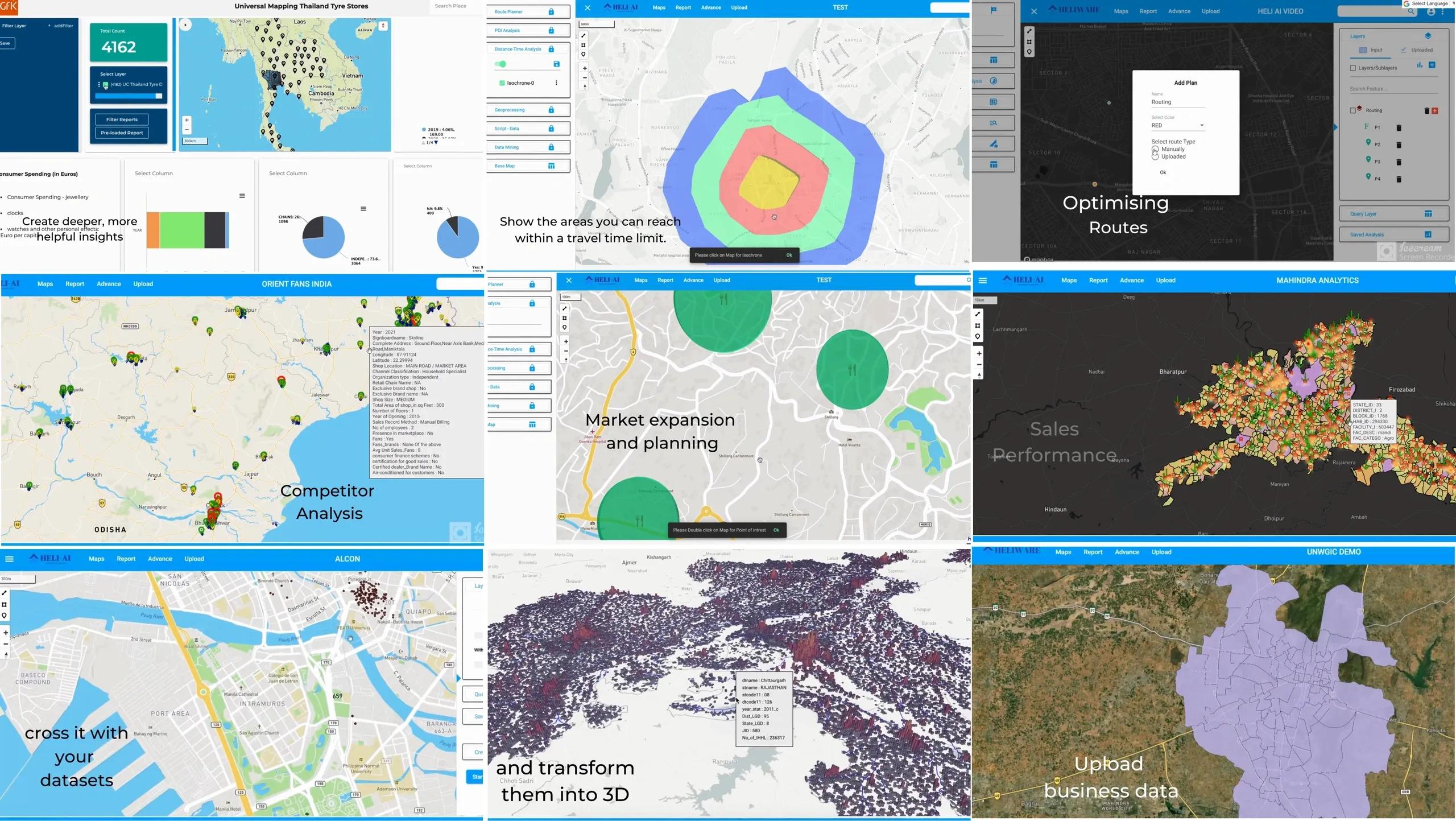
The rise of geospatial analytics is profoundly transforming decision-making across industries. This powerful technology, which leverages spatial data to generate actionable insights, has evolved into a critical tool for businesses looking to optimize operations, enhance strategic planning, and drive growth. At the forefront of this transformation is Heliware 's geospatial analytics platform, which integrates advanced AI to analyze vast datasets and provide precise, real-time insights. This article explores how geospatial analytics is revolutionizing decision-making across various sectors, from urban planning to logistics and energy.
Understanding Geospatial Analytics
Geospatial analytics refers to the gathering, display, and manipulation of imagery, GPS, satellite photography, and historical data, represented on a geographic map. This technology allows organizations to visualize patterns, relationships, and trends within complex datasets. By adding the dimension of location, geospatial analytics enables a deeper understanding of data, uncovering insights that might not be apparent through traditional analysis methods.
Heliware ’s platform is a prime example of how geospatial analytics can be harnessed to deliver these insights. The platform is designed to handle diverse data sources, including satellite imagery, drone data, and LiDAR, and applies advanced algorithms to produce meaningful and actionable information. This capability is essential for industries that rely on precision and efficiency in their operations.
Enhancing Urban Planning
Urban planning is one of the most impactful applications of geospatial analytics. City planners and developers require detailed, real-time information to design infrastructure that meets the needs of growing populations while addressing environmental concerns. Geospatial analytics provides the tools necessary to analyze land use, transportation networks, and population density, allowing for informed decisions on where to build roads, schools, and hospitals.
For instance, Heliware ’s platform allows urban planners to create 3D models of cities, enabling them to simulate different scenarios and assess the impact of new developments before construction begins. By integrating AI, the platform can predict how changes in the urban environment—such as new buildings or roadways—will affect traffic patterns, energy consumption, and other critical factors.
This approach not only optimizes the use of available space but also enhances sustainability efforts. For example, the platform can identify the most suitable locations for green spaces and renewable energy installations, helping cities reduce their carbon footprint and improve the quality of life for residents.
Optimizing Logistics and Supply Chain Management
In the logistics and supply chain industry, the ability to track and manage assets in real-time is crucial. Geospatial analytics provides a powerful tool for optimizing routes, monitoring fleet movements, and improving overall supply chain efficiency. With the integration of geospatial data, companies can ensure timely deliveries, reduce fuel consumption, and respond quickly to disruptions.
Heliware ’s platform offers advanced capabilities for logistics optimization. It enables companies to visualize and analyze their entire distribution network, from warehouses to final delivery points. By utilizing data such as road conditions, traffic patterns, and weather forecasts, the platform can generate optimal delivery routes that minimize delays and reduce operational costs.
Furthermore, the platform’s real-time monitoring features provide visibility into every aspect of the supply chain. This transparency allows companies to track shipments, manage inventory levels, and respond to potential issues before they escalate. For instance, if a vehicle deviates from its route due to unexpected road closures, the system can automatically reroute the delivery, ensuring that customers receive their products on time.
Advancing the Energy Sector
The energy sector is another industry that benefits significantly from geospatial analytics. Energy companies use this technology to identify optimal sites for renewable energy projects, monitor infrastructure, and manage environmental risks. By analyzing spatial data, these companies can make more informed decisions about where to invest and how to manage their resources.
Heliware ’s platform provides energy companies with the tools needed to conduct site suitability analyses for renewable energy projects. By integrating data on land use, weather patterns, and proximity to the power grid, the platform can identify locations that offer the highest potential for solar, wind, or hydroelectric power generation. This capability is essential for maximizing the return on investment in renewable energy projects.
Additionally, geospatial analytics is used to monitor existing energy infrastructure. For example, the platform can analyze satellite and drone imagery to detect potential issues with power lines, pipelines, and other critical assets. This early detection allows companies to address problems before they lead to costly outages or environmental damage.
Transforming Retail and Consumer Insights
In the retail sector, understanding consumer behavior is key to success. Geospatial analytics provides retailers with the insights needed to optimize store locations, tailor marketing strategies, and enhance the customer experience. By analyzing demographic data, foot traffic patterns, and spending habits, retailers can make data-driven decisions that boost sales and customer satisfaction.
Heliware ’s platform enables retailers to conduct detailed market analyses that consider a wide range of spatial factors. For example, the platform can identify the most promising locations for new stores based on population density, income levels, and proximity to competitors. Retailers can also use geospatial analytics to design targeted marketing campaigns that reach the right customers at the right time.
Moreover, geospatial analytics can enhance in-store experiences by providing real-time data on customer movements. Retailers can use this information to optimize store layouts, ensuring that high-demand products are placed in easily accessible locations. This data can also inform inventory management decisions, reducing the risk of stock-outs and overstocking.
Improving Public Safety and Emergency Response
Public safety agencies are increasingly relying on geospatial analytics to improve their operations. From disaster response to crime prevention, this technology provides the situational awareness needed to make quick and effective decisions. By analyzing spatial data, agencies can identify high-risk areas, allocate resources more efficiently, and respond more effectively to emergencies.
Heliware ’s platform supports public safety efforts by providing real-time mapping and analytics tools. For instance, during a natural disaster, the platform can integrate data from various sources—such as satellite imagery, weather reports, and social media—to create a comprehensive view of the affected area. This information helps emergency responders coordinate their efforts, ensuring that aid reaches those in need as quickly as possible.
In crime prevention, geospatial analytics can be used to identify patterns and predict future incidents. Law enforcement agencies can analyze data on crime hotspots, traffic flows, and social behavior to deploy resources more effectively. This proactive approach not only helps prevent crime but also improves community relations by addressing issues before they escalate.
In conclusion, Geospatial analytics is revolutionizing decision-making across industries by providing the tools needed to analyze spatial data and generate actionable insights. From urban planning and logistics to energy and retail, this technology is helping organizations optimize their operations, reduce costs, and improve outcomes. Heliware ’s geospatial analytics platform exemplifies the power of this technology, offering advanced AI-driven capabilities that empower businesses to make more informed decisions. As industries continue to embrace geospatial analytics, the ability to leverage location-based data will become increasingly critical to staying competitive in a rapidly changing world.