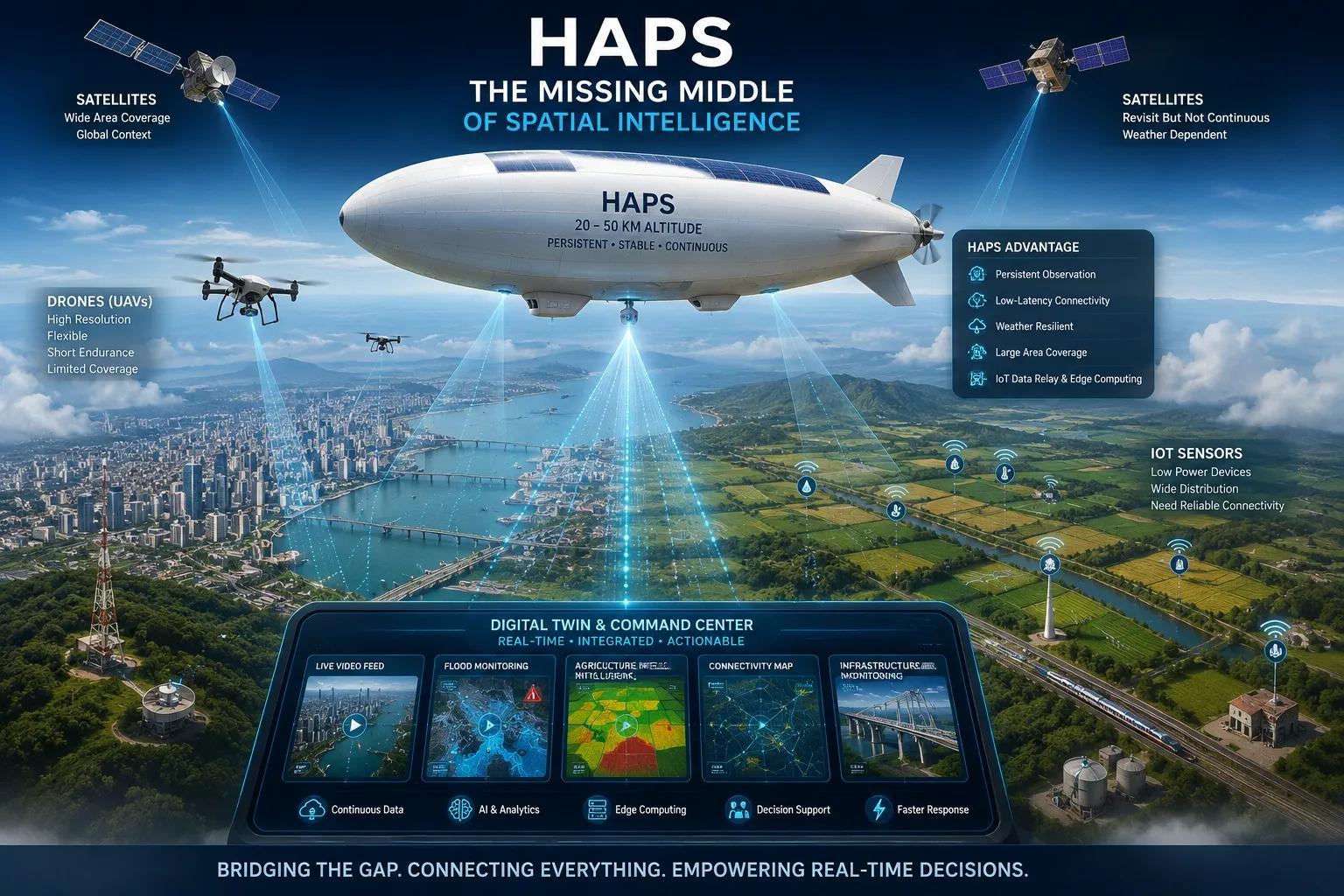
For years, Earth observation has worked with a major operational gap.
At one end, we have UAVs.
They give high-resolution, flexible, local data. They can fly low, capture detailed imagery, support inspections, and serve project-level needs. But their limitation is clear: short endurance, small coverage, flight permissions, line-of-sight constraints, and frequent deployment planning.
At the other end, we have satellites.
They give scale. They can cover cities, regions, countries, coastlines, forests, farms, and infrastructure corridors. But they also come with limits: revisit gaps, weather dependency, latency, lower flexibility, and in many cases, lack of persistent observation over one specific area.
Between these two layers sits one of the most important emerging technologies in spatial intelligence:
High-Altitude Platform Stations, or HAPS.
HAPS may become the missing middle of Earth observation.
They are not drones in the traditional sense.
They are not satellites either.
They are autonomous high-altitude platforms, often solar-powered aircraft or stratospheric airships, designed to operate above commercial airspace and weather systems. Positioned in the stratosphere, they can remain over a defined geography for long durations and provide continuous observation, communication, and data relay.
This changes the way we think about digital twins, IoT, disaster response, telecom, agriculture, defence, and regional monitoring.
Because the real challenge is no longer just capturing spatial data.
The real challenge is continuity.
The Problem: Spatial Data Still Comes in Fragments
Most digital twin discussions start with 3D models, dashboards, sensors, and AI.
But before any of that works, one question matters:
How often does the physical world update the digital world?
If a city digital twin is updated once a month, it is useful for planning.
If it is updated once a week, it is useful for monitoring.
If it is updated once a day, it is useful for operational awareness.
But if it is updated continuously, it starts becoming a decision-support system.
That is where the current spatial stack struggles.
Drone data is accurate but periodic.
Satellite data is scalable but not always continuous.
Ground sensors are useful but limited by installation cost, connectivity, and maintenance.
CCTV gives local visibility but does not provide regional spatial context.
IoT networks work well in connected zones but become difficult across rural, coastal, offshore, forest, or disaster-hit regions.
This is why HAPS matters.
It is not just another flying platform.
It introduces persistence.
And persistence is what turns mapping into intelligence.
Why HAPS Is Strategically Important
HAPS can combine three capabilities that are usually difficult to achieve together:
High endurance.
Wide area coverage.
Low-latency communication.
For sectors that depend on real-time or near-real-time awareness, this is a major shift.
A HAPS platform can stay above a specific area and provide a continuous observational layer. It can support live imaging, communication relay, IoT data collection, thermal monitoring, and edge-based analytics.
In simple terms, it can act as a bridge between ground infrastructure and space infrastructure.
For smart cities, it can support traffic observation, flood monitoring, emergency communication, infrastructure surveillance, and urban operations.
For agriculture, it can support crop stress monitoring, irrigation intelligence, rural sensor connectivity, pest and disease surveillance, and regional productivity planning.
For disaster management, it can restore communication when terrestrial networks fail and provide live situational awareness during floods, cyclones, wildfires, landslides, or earthquakes.
For telecom, it can support remote connectivity, temporary coverage, and network resilience.
For defence and border management, it can provide persistent surveillance without the limitations of short-duration aerial missions.
For offshore and coastal infrastructure, it can support monitoring where ground networks are weak or unavailable.
This is why HAPS should not be seen only as an aerospace innovation.
It should be seen as a spatial infrastructure layer.
The Digital Twin Connection
Digital twins need live context.
A model without live data is only a digital replica.
A dashboard without spatial continuity is only a reporting layer.
A simulation without operational feeds is only a planning exercise.
For digital twins to become useful in day-to-day operations, they need a continuous connection with the physical environment.
HAPS can support this connection.
Imagine a flood-prone city where drainage models, rainfall data, ground sensors, road cameras, and HAPS-based observation are integrated into one live operational twin.
The city does not wait for manual reports.
The twin detects where water is accumulating, which roads are becoming inaccessible, which zones need diversion, and where emergency teams should move first.
Now imagine a large agricultural region where soil sensors, weather forecasts, crop models, satellite imagery, and HAPS feeds work together.
Farmers and agencies do not only see crop health after damage has occurred.
They can monitor stress patterns, identify irrigation gaps, detect local anomalies, and trigger timely advisory workflows.
This is the difference between a digital twin as a visual platform and a digital twin as an operating layer.
HAPS strengthens that operating layer.
The IoT Connectivity Angle
One of the less-discussed roles of HAPS is IoT connectivity.
Many rural, offshore, mining, forest, and infrastructure environments cannot depend on dense terrestrial networks.
Sensors may be present, but communication becomes the bottleneck.
Sending every signal directly to satellite can be costly and power-intensive.
Building ground networks everywhere is often impractical.
A HAPS platform can serve as a localized edge relay.
It can collect low-power IoT signals from the ground and transmit them to central systems. This can reduce dependence on heavy field infrastructure and improve coverage across difficult regions.
This is especially relevant for large-scale environmental monitoring, smart agriculture, utility corridors, pipeline monitoring, disaster zones, and remote industrial operations.
In this role, HAPS is not only observing the Earth.
It is helping the Earth communicate.
Why This Matters for India
India has a strong need for continuous spatial intelligence.
Our cities face floods, traffic congestion, encroachment, heat stress, and infrastructure pressure.
Our agriculture depends on timely decisions across millions of hectares.
Our coastlines need monitoring for security, climate risk, and marine activity.
Our rural regions still need stronger connectivity and better digital service delivery.
Our disaster response systems need faster situational awareness.
HAPS fits into many of these needs.
Recent developments in India show that this space is no longer theoretical. Startups are beginning to test high-altitude airship platforms in challenging environments, including coastal and mid-sea conditions. These trials are important because they validate basic requirements such as structural stability, communication links, live monitoring, and operational control.
That is the foundation required before HAPS can move into larger commercial and strategic deployments.
India should look at HAPS not only from an aerospace perspective but from a national digital infrastructure perspective.
The Business Opportunity
For geospatial companies, digital twin providers, telecom players, defence innovators, disaster management agencies, and infrastructure operators, HAPS opens a new opportunity.
The future spatial stack may not be built on one data source.
It will be hybrid.
Ground sensors will capture local conditions.
Drones will capture detailed project-level data.
Satellites will provide regional and global context.
HAPS will provide persistent mid-layer observation and communication.
AI will convert these signals into decisions.
Digital twins will organize them into operational workflows.
This is where service providers need to evolve.
The opportunity is not just to create maps.
It is to design HAPS-ready spatial architectures.
That means building systems that can ingest continuous aerial feeds, connect with IoT networks, support edge analytics, update digital twins, and deliver decision-ready intelligence.
The companies that prepare for this now will not compete only as data vendors.
They will become real-time intelligence partners.
The GeoThinking Lens
Every new technology creates excitement.
But the real question is not whether HAPS is impressive.
The real question is where it creates measurable value.
Does it reduce response time during disasters?
Does it improve connectivity in remote regions?
Does it make digital twins more operational?
Does it reduce the cost of large-area monitoring?
Does it help governments and industries act before risk becomes damage?
That is where HAPS must prove itself.
The promise is strong.
But adoption will depend on use-case clarity, regulatory alignment, platform reliability, data integration, cost models, and operational partnerships.
For me, the biggest value of HAPS is this:
It can make spatial intelligence more continuous.
And continuity is the foundation of better decisions.
Because in the next phase of digital transformation, the winners will not be the organizations that collect the most data.
They will be the ones that sense change early, understand it in context, and act before the window closes.
HAPS may become one of the key layers that makes this possible.
The sky is no longer just a space for observation.
It is becoming an operating layer for connected intelligence.
What do you think?
Can HAPS become the missing middle between drones, satellites, IoT, and digital twins?