For years, geospatial technology has helped organizations answer one major question:
What is happening where?
Satellite imagery, UAVs, IoT sensors, BIM models, Digital Twins, and AI have made physical reality more visible, measurable, and interpretable.
But the next shift is bigger.
The question is no longer only:
What is happening where?
It is becoming:
Can trusted spatial evidence trigger action automatically?
This is where Geospatial Oracles and Parametric Smart Contracts become important.
They represent a new layer in the geospatial technology stack - one that connects physical reality to automated financial, regulatory, insurance, compliance, and sustainability execution.
In simple terms:
A Digital Twin helps us understand reality.
A Geospatial Oracle helps us verify reality.
A Parametric Smart Contract helps us act on verified reality.
That shift can move geospatial intelligence from observation to execution.
The Problem: Digital Systems Are Still Blind to Physical Reality
Blockchains, smart contracts, automated compliance platforms, and digital financial systems cannot directly see the real world.
They do not know whether a farm received enough rainfall.
They do not know whether forest cover was maintained.
They do not know whether a road corridor was damaged after flooding.
They do not know whether a warehouse shipment came from a compliant location.
They do not know whether a carbon project still has the biomass it claimed last month.
These systems need trusted external evidence.
That is the role of an oracle.
In the geospatial context, an oracle becomes the trusted bridge between physical reality and automated digital execution.
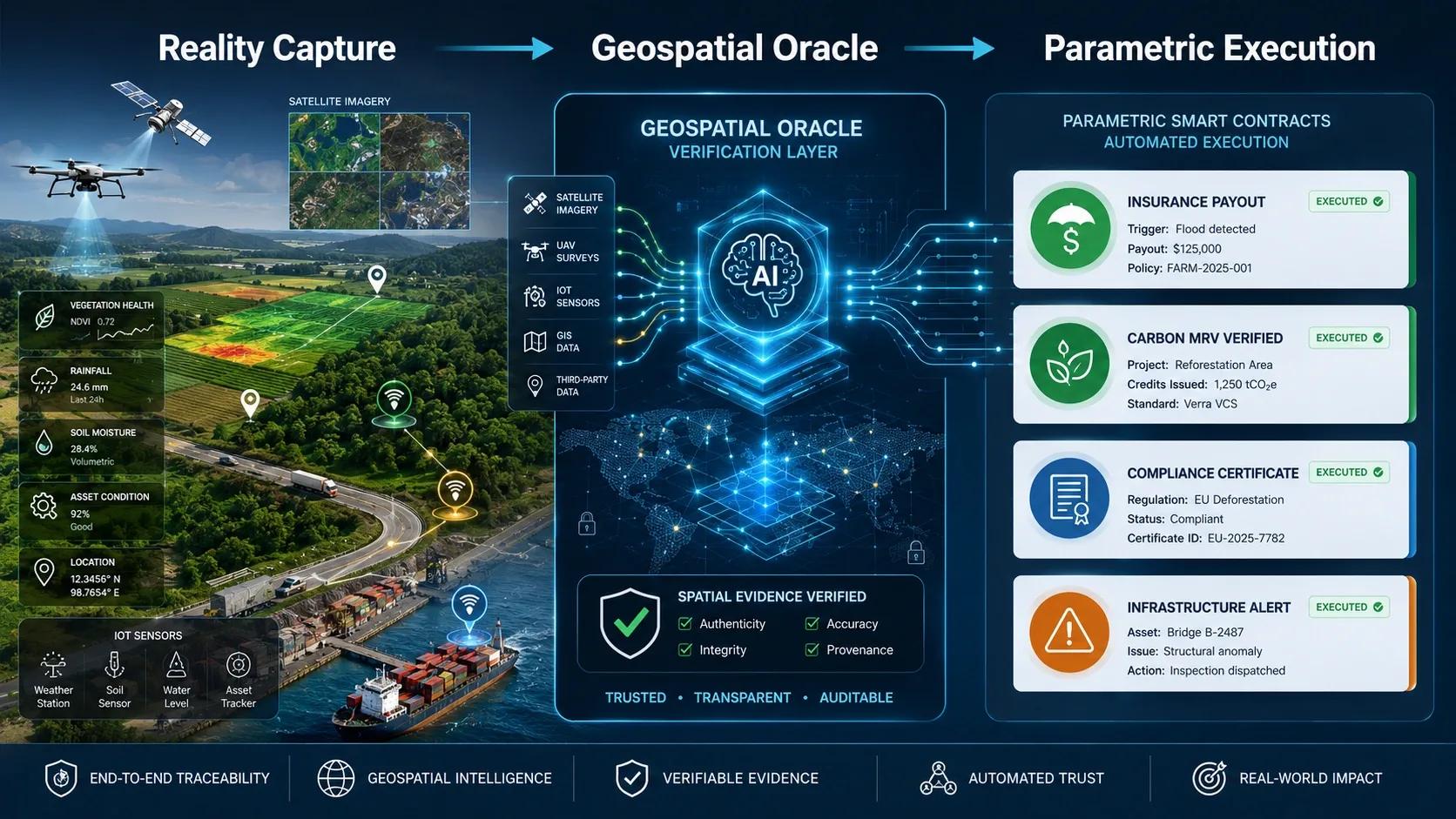
A Geospatial Oracle can receive inputs from satellites, UAVs, IoT sensors, field surveys, BIM models, Digital Twins, and AI pipelines. It then converts that evidence into a verified digital answer that another system can trust.
For example:
“Did this farm receive less than 15 mm rainfall for 30 consecutive days?”
“Did this hectare maintain at least 80% canopy cover this month?”
“Is this shipment linked to a compliant origin coordinate?”
“Has this infrastructure asset crossed a risk threshold?”
“Does the current satellite evidence match the carbon claim?”
The power is not just in answering these questions.
The power is in what happens next.
The Shift: From Manual Verification to Automated Trust
Most compliance, insurance, sustainability, and supply chain workflows still depend heavily on manual verification.
A claim is filed.
An inspector is assigned.
A report is prepared.
A document is reviewed.
A certificate is issued.
A payout is approved.
A compliance decision is made.
This process is slow, expensive, and often inconsistent.
In many sectors, the bottleneck is not lack of data. The bottleneck is trust in the data and the time taken to convert that trust into action.
Geospatial Oracles can reduce that gap.
They can combine multiple layers of spatial evidence, validate the condition, and send a verified output to a smart contract or automated workflow.
That workflow can then trigger a predefined action.
This is the foundation of parametric execution.
A parametric contract does not wait for long manual interpretation. It executes when a predefined condition is met.
For example:
If rainfall falls below a defined threshold, insurance payout is triggered.
If vegetation cover is maintained, conservation payment is released.
If a shipment origin passes spatial compliance checks, a certificate is issued.
If flood exposure crosses a defined risk level, emergency funding is activated.
If a digital twin confirms asset condition, maintenance payment is approved.
The decision is not based on opinion.
It is based on verified spatial evidence.
The Architecture: Reality Capture, Oracle Layer, Execution Layer
This stack can be understood in three simple layers.
1. Reality Capture: The Senses
This is where the physical world is measured.
The inputs may include:
Satellite imagery
UAV surveys
IoT sensors
Weather data
BIM and asset models
Mobile mapping
Field inspection records
LiDAR and 3D scans
Enterprise operational data
This layer captures what is happening on the ground, in the field, across the corridor, inside the facility, or within the supply chain.
But raw data is not enough.
A satellite image may have cloud cover.
A sensor may fail.
A drone image may need calibration.
A field record may be incomplete.
An asset location may be outdated.
So the next layer becomes critical.
2. The Geospatial Oracle: The Brain
The oracle does not merely pass data from one system to another.
It verifies.
It checks.
It filters anomalies.
It compares evidence across sources.
It applies AI and geospatial logic.
It confirms whether the required condition has actually been met.
For example, a Geospatial Oracle may combine Sentinel satellite imagery, UAV data, soil moisture readings, rainfall records, and historical land cover data to verify whether a farming grid qualifies for drought support.
Or it may combine digital twin data, inspection records, and IoT readings to confirm whether an infrastructure asset has crossed a maintenance threshold.
The oracle converts complex spatial evidence into a clear digital answer.
Yes or no.
Above threshold or below threshold.
Compliant or non-compliant.
Verified or not verified.
That answer can then be passed into an automated contract or workflow.
3. Parametric Smart Contract: The Action
This is where execution happens.
The smart contract contains predefined rules.
When the oracle confirms that a condition has been met, the contract can trigger the next action automatically.
This may include:
Insurance payout
Compliance certificate
Carbon credit validation
Supplier approval
Maintenance release
Emergency response funding
Incentive payment
Regulatory alert
Audit record creation
This is the important part:
The geospatial system is no longer only producing a report.
It is enabling action.
That is a major shift for the industry.
Where This Matters Most
1. Parametric Agricultural Insurance
Agriculture insurance often suffers from delayed claims, manual assessments, and disputes around loss verification.
A Geospatial Oracle can monitor rainfall, soil moisture, crop health, and vegetation stress across defined farming grids.
If the agreed drought or flood condition is reached, the parametric contract can trigger payout without waiting for a traditional claims process.
This can be powerful for small farmers, insurers, governments, and climate risk programs.
The farmer does not need to prove the event repeatedly.
The system verifies the event using trusted spatial evidence.
2. Carbon Credit dMRV
Carbon markets depend on trust.
It is not enough to say that trees were planted or biomass was preserved.
Buyers want proof.
Regulators want proof.
Auditors want proof.
Communities want fairness.
A Geospatial Oracle can continuously monitor biomass, canopy cover, land-use change, project boundaries, and disturbance patterns.
If the digital evidence confirms that the carbon condition remains valid, a smart contract can unlock payments, issue records, or update the project status.
This moves carbon MRV from periodic reporting to continuous digital assurance.
That is a major step for climate finance.
3. Supply Chain and Export Compliance
Global supply chains are increasingly expected to prove origin, traceability, and environmental compliance.
For agriculture, forestry, minerals, and other land-linked commodities, location matters.
A Geospatial Oracle can verify whether a shipment is connected to a compliant origin coordinate.
It can cross-check land cover history, protected areas, risk zones, and supplier boundaries.
Instead of depending only on paperwork, compliance can be supported by spatial evidence.
This can reduce audit delays and improve trust between exporters, buyers, regulators, and financiers.
4. Infrastructure Resilience and Maintenance
Infrastructure owners are under pressure to respond faster to risk.
Roads, bridges, utilities, ports, airports, and industrial assets are exposed to weather, usage, aging, and operational stress.
A Geospatial Oracle can combine asset location, inspection data, IoT readings, weather alerts, and digital twin conditions.
When a risk threshold is crossed, automated workflows can trigger maintenance actions, budget approvals, alerts, or escalation.
This can help move infrastructure management from reactive reporting to evidence-based execution.
Why This Is Strategic for Geospatial Companies
The value proposition changes.
Earlier, the promise was:
“We provide spatial data.”
Then it became:
“We provide dashboards and Digital Twins.”
Now it can become:
“We provide trusted spatial evidence that can trigger decisions.”
That is a higher-value position.
It connects geospatial intelligence with insurance, finance, compliance, ESG, supply chain, infrastructure operations, and climate resilience.
This is where the industry can move beyond maps and models.
The real opportunity is to build systems where spatial intelligence becomes part of the operating logic of the business.
Not just visualization.
Not just reporting.
Not just monitoring.
But verified execution.
The New Direction: From Digital Twin to Economic Engine
A passive Digital Twin shows the current state of an asset, farm, city, forest, warehouse, or corridor.
An active Digital Twin can support decisions.
But when a Digital Twin is connected to Geospatial Oracles and Parametric Smart Contracts, it can become something more powerful:
An economic engine.
It can verify outcomes.
It can reduce disputes.
It can improve compliance confidence.
It can accelerate payouts.
It can support climate finance.
It can create auditable evidence trails.
It can convert physical-world events into trusted digital execution.
That is the frontier.
Geospatial intelligence is no longer only about seeing the world better.
It is about helping organizations act on the world with greater speed, trust, and accountability.
At BSMA, we see this as an important direction for the next generation of geospatial platforms - where UAVs, IoT, Digital Twins, AI, and spatial evidence systems converge to support automated compliance, sustainability, insurance, and infrastructure decisions.
The future of geospatial is not only maps.
It is not only dashboards.
It is not only Digital Twins.
The future is trusted spatial intelligence that can trigger real-world action.
And Geospatial Oracles may become one of the most important bridges in that journey.